Vella

Last updated • 5 min readFrom Wikipedia, The Free Encyclopedia
Vella
Vella.jpg
VellaCA.jpeg
Location of Vella
Vella
Switzerland adm location map.svg
Red pog.svg
Vella
Reliefkarte Graubunden blank.png
Red pog.svg
Vella
Coordinates: 46°43′N9°10′E / 46.717°N 9.167°E / 46.717; 9.167
Country Switzerland
Canton Graubünden
District Surselva
Government
   Mayor Daniel Blumenthal
Area
  Total7.42 km2 (2.86 sq mi)
Elevation
1,244 m (4,081 ft)
Population
 (Dec 2011)
  Total438
  Density59/km2 (150/sq mi)
Time zone UTC+01:00 (Central European Time)
  Summer (DST) UTC+02:00 (Central European Summer Time)
Postal code(s)
7144
SFOS number 3605
ISO 3166 code CH-GR
Surrounded by Cumbel, Degen, Morissen, Obersaxen, Suraua, Surcuolm
Website www.vallumnezia.ch
SFSO statistics

Vella is a village and a former municipality in the district of Surselva in the canton of Graubünden in Switzerland. The municipalities of Cumbel, Degen, Lumbrein, Morissen, Suraua, Vignogn, Vella, and Vrin merged on 1 January 2013 into the new municipality of Lumnezia. [1]

Contents

History

While there is some evidence of a late Bronze Age settlement and coins from the 3rd and 4th Centuries have been found, Vella is first mentioned about 840 as ad sanctum Vincentium [...] in valle Leguntia. In 1290-98 it was mentioned as ad Ville, aput Villam. [2] The village church was the center of a parish that covered the entire valley. However, about 1300 Vals separated from the parish due to the desire of Walser German speaking Walser immigrants to have their own religious leadership. Over the following centuries, most of the other villages in the valley also separated from the Vella parish (the most recent being Peiden in 1910). Due to the village's function as a religious center and the power of a local patrician family, de Mont, Vella grew to be the most powerful village in the valley. Since 1887, it has been home to the sub-district secondary school. [2]

Coat of arms

The description of the municipal coat of arms is Azure a Pelican in Piety Argent. [3] The pelican, which according to legend feeds its young with its own blood, is a symbol for the death of Jesus. By extension, it can also represent the entire church. In this case, it stands for the parish church for the Lugnez valley, which is in Degen.

Geography

Vella had an area, as of 2006, of 7.4 km2 (2.9 sq mi). Of this area, 69.5% is used for agricultural purposes, while 18.6% is forested. Of the rest of the land, 4.6% is settled (buildings or roads) and the remainder (7.3%) is non-productive (rivers, glaciers or mountains). [4]

The former municipality is located in the Lugnez sub-district of the Surselva district. It is located at 1,244 m (4,081 ft) ft altitude on a plateau in the centre of the Lumnezia, a high alpine valley.

The municipality consists of the village Villa and the church St. Vincent in Pleif built on a ridge overlooking the Glenner/Glogn gorge, a tributary to the Vorderrhein. The highest elevation is Mount Stein at 2,172 meters (7,126 ft) altitude.

Until 1987 Vella was known as Villa (GR). [5]

Demographics

Vella had a population (as of 2011) of 438. [6] As of 2008, 2.9% of the population was made up of foreign nationals. [7] Over the last 10 years the population has decreased at a rate of -3.4%. Most of the population (as of 2000) speaks Romansh (83.9%), with German being second most common (13.6%) and Serbo-Croatian being third ( 1.1%). [4]

As of 2000, the gender distribution of the population was 50.8% male and 49.2% female. [8] The age distribution, as of 2000, in Vella is; 63 children or 14.3% of the population are between 0 and 9 years old and 54 teenagers or 12.2% are between 10 and 19. Of the adult population, 44 people or 10.0% of the population are between 20 and 29 years old. 61 people or 13.8% are between 30 and 39, 82 people or 18.6% are between 40 and 49, and 44 people or 10.0% are between 50 and 59. The senior population distribution is 37 people or 8.4% of the population are between 60 and 69 years old, 34 people or 7.7% are between 70 and 79, there are 21 people or 4.8% who are between 80 and 89,and there is 1 person who is between 90 and 99. [7]

In the 2007 federal election the most popular party was the CVP which received 54.2% of the vote. The next three most popular parties were the SVP (23.8%), the FDP (14.2%) and the SP (7.8%). [4]

In Vella about 70.7% of the population (between age 25-64) have completed either non-mandatory upper secondary education or additional higher education (either university or a Fachhochschule ). [4]

Vella has an unemployment rate of 0.86%. As of 2005, there were 17 people employed in the primary economic sector and about 7 businesses involved in this sector. 66 people are employed in the secondary sector and there are 10 businesses in this sector. 101 people are employed in the tertiary sector, with 27 businesses in this sector. [4]

The historical population is given in the following table: [2] [8]

yearpopulation
1808199
1835301
1850229
1900272
1950418
1990398
2000441

Weather

Vella has an average of 116 days of rain or snow per year and on average receives 1,004 mm (39.5 in) of precipitation. The wettest month is August during which time Vella receives an average of 115 mm (4.5 in) of rain or snow. During this month there is precipitation for an average of 11.5 days. The month with the most days of precipitation is May, with an average of 11.7, but with only 100 mm (3.9 in) of rain or snow. The driest month of the year is February with an average of 55 mm (2.2 in) of precipitation over 11.5 days. [9]

Heritage sites of national significance

Church of St. Vincent Vella Kirche St.Vinzenz.jpg
Church of St. Vincent

The Church of S. Vincenz/St. Vincent is listed as a Swiss heritage site of national significance. [10]

The church is first mentioned about 843, when it was given Imperial support. It later came under the patronage of the Welfs and in the mid 10th century came under the authority of the cathedral of Constance. By the 14th Century it was owned by the Freiherr of Belmont, but in 1371 was inherited by the family of Sax-Misox. Then, in 1483 it came under the authority of the Bishop of Chur. The Gothic/Romanesque church was rebuilt in 1661-62. [2]

Related Research Articles

<span class="mw-page-title-main">Suraua</span> Former municipality in Graubünden, Switzerland

Suraua is a former municipality in the district of Surselva in the canton of Graubünden in Switzerland. The former municipality was formed on January 1, 2002, through the union of Camuns, Surcasti, Tersnaus, and Uors-Peiden. The municipalities of Cumbel, Degen, Lumbrein, Morissen, Suraua, Vignogn, Vella, and Vrin merged on 1 January 2013 into the new municipality of Lumnezia.

<span class="mw-page-title-main">Ilanz</span> Former municipality in Grisons, Switzerland

Ilanz is a former municipality in the district of Surselva in the Swiss canton of the Grisons. The former municipality of Ilanz was congruent with the town of Ilanz. On 1 January 1978, the former municipality of Strada merged into the new municipality of Ilanz. On 1 January 2014, the municipality of Ilanz and the surrounding municipalities Castrisch, Ladir, Luven, Pitasch, Riein, Ruschein, Schnaus, Sevgein, Duvin, Pigniu, Rueun and Siat merged into the new municipality of Ilanz/Glion.

<span class="mw-page-title-main">Vals, Switzerland</span> Municipality in Graubünden, Switzerland

Vals is a village and a municipality in the Surselva Region in the canton of Graubünden in Switzerland. On 1 January 2015 the former municipality of St. Martin merged into the municipality of Vals.

<span class="mw-page-title-main">Obersaxen</span> Municipality in Graubünden, Switzerland

Obersaxen is a former municipality in the district of Surselva in the Swiss canton of Graubünden. On 1 January 2016 the former municipalities of Obersaxen and Mundaun merged to form the new municipality of Obersaxen Mundaun.

<span class="mw-page-title-main">Lumnezia</span> Municipality in Grisons, Switzerland

Lumnezia is a valley region and a municipality in the Surselva Region in the Swiss of canton of Graubünden. The former municipalities of Cumbel, Degen, Lumbrein, Morissen, Suraua, Vignogn, Vella, and Vrin merged on 1 January 2013 into the new municipality of Lumnezia. It covers the Val Lumnezia, a Swiss high alpine valley. Its upper regions are among the most remote areas in the Swiss Alps. The official language is Romansh.

<span class="mw-page-title-main">Morissen</span> Former municipality in Graubünden, Switzerland

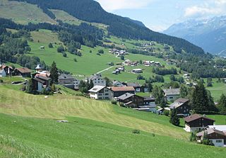
Morissen is a former municipality in the district of Surselva in the Swiss canton of Graubünden. The municipalities of Cumbel, Degen, Lumbrein, Morissen, Suraua, Vignogn, Vella, and Vrin merged on 1 January 2013 into the new municipality of Lumnezia.

<span class="mw-page-title-main">Trun, Switzerland</span> Municipality in Graubünden, Switzerland

Trun is a municipality in the Surselva Region in the canton of Graubünden in Switzerland. The municipality of Schlans merged on 1 January 2012 into the municipality of Trun.

<span class="mw-page-title-main">Avers</span> Municipality in Grisons, Switzerland

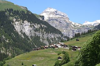
Avers is a high Alpine valley region and a municipality in the Viamala Region in the Swiss canton of Graubünden. It includes Juf, the highest-altitude year-round settlement in Europe.

<span class="mw-page-title-main">Andiast</span> Former municipality in Graubünden, Switzerland

Andiast is a former municipality in the Surselva Region in the Swiss canton of Graubünden. Until 1943, it was known as Andest.

<span class="mw-page-title-main">Tiefencastel</span> Former municipality in Graubünden, Switzerland

Tiefencastel is a village and a former municipality in the district of Albula in the canton of Graubünden in Switzerland. On 1 January 2015 the former municipalities of Alvaschein, Mon, Stierva, Tiefencastel, Alvaneu, Brienz/Brinzauls and Surava merged to form the new municipality of Albula/Alvra.

<span class="mw-page-title-main">Cumbel</span> Former municipality in Graubünden, Switzerland

Cumbel is a former municipality in the district of Surselva in the Swiss canton of Graubünden. The municipalities of Cumbel, Degen, Lumbrein, Morissen, Suraua, Vignogn, Vella, and Vrin merged on 1 January 2013 into the new municipality of Lumnezia.

<span class="mw-page-title-main">Degen, Switzerland</span> Former municipality in Graubünden, Switzerland

Degen is a former municipality in the district of Surselva in the Swiss canton of Graubünden. Until 1983, it was officially known as Igels. The municipalities of Cumbel, Degen, Lumbrein, Morissen, Suraua, Vignogn, Vella, and Vrin merged on 1 January 2013 into the new municipality of Lumnezia.

<span class="mw-page-title-main">Duvin</span> Former municipality in Graubünden, Switzerland

Duvin, Romansh: Duin ) is a former municipality in the district of Surselva in the Swiss canton of Graubünden. On 1 January 2014 the former municipalities of Duvin, Castrisch, Ilanz, Ladir, Luven, Pitasch, Riein, Ruschein, Schnaus, Sevgein, Pigniu, Rueun and Siat merged into the new municipality of Ilanz/Glion.

<span class="mw-page-title-main">Lumbrein</span> Former municipality in Graubünden, Switzerland

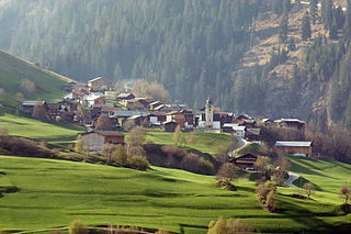
Lumbrein is a former municipality in the district of Surselva in the Swiss canton of Graubünden. The municipalities of Cumbel, Degen, Lumbrein, Morissen, Suraua, Vignogn, Vella, and Vrin merged on 1 January 2013 into the new municipality of Lumnezia.

<span class="mw-page-title-main">Pigniu</span> Former municipality in Graubünden, Switzerland

Pigniu is a former municipality in the district of Surselva in the canton of Graubünden in Switzerland. Its official language is Romansh. On 1 January 2014 the former municipalities of Pigniu, Castrisch, Ilanz, Ladir, Luven, Pitasch, Riein, Ruschein, Schnaus, Sevgein, Duvin, Rueun and Siat merged into the new municipality of Ilanz/Glion.

<span class="mw-page-title-main">Tujetsch</span> Municipality in Graubünden, Switzerland

Tujetsch is a municipality in the Surselva Region in the canton of Graubünden in Switzerland. It is the westernmost municipality of the canton, connected to Urseren by the Oberalp Pass.

<span class="mw-page-title-main">Vignogn</span> Former municipality in Graubünden, Switzerland

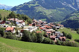
Vignogn is a former municipality in the district of Surselva in the canton of Graubünden in Switzerland. The municipalities of Cumbel, Degen, Lumbrein, Morissen, Suraua, Vignogn, Vella, and Vrin merged on 1 January 2013 into the new municipality of Lumnezia.

<span class="mw-page-title-main">Vrin</span> Former municipality in Graubünden, Switzerland

Vrin is a village and a former municipality in the Lumnezia. It belonged to the circle of Lugnez/Lumnezia in the district of Surselva in the canton of Graubünden in Switzerland. The municipalities of Cumbel, Degen, Lumbrein, Morissen, Suraua, Vignogn, Vella, and Vrin merged on 1 January 2013 into the new municipality of Lumnezia.

<span class="mw-page-title-main">St. Martin, Graubünden</span> Former municipality in Graubünden, Switzerland

St. Martin is a village and was a municipality in the district of Surselva in the Swiss canton of Graubünden. On 1 January 2015 the former municipality of St. Martin merged into the municipality of Vals.

Surselva Region is one of the eleven administrative districts in the canton of Graubünden in Switzerland. It was created on 1 January 2017 as part of a reorganization of the canton.

References

  1. Amtliches Gemeindeverzeichnis der Schweiz published by the Swiss Federal Statistical Office (in German) accessed 2 January 2013
  2. 1 2 3 4 Vella in German , French and Italian in the online Historical Dictionary of Switzerland .
  3. Flags of the World.com accessed 25-Nov-2009
  4. 1 2 3 4 5 Swiss Federal Statistical Office accessed 25-Nov-2009
  5. Amtliches Gemeindeverzeichnis der Schweiz published by the Swiss Federal Statistical Office (in German) accessed 23 September 2009
  6. Swiss Federal Statistics Office – STAT-TAB Archived 2012-09-21 at WebCite Ständige und Nichtständige Wohnbevölkerung nach Region, Geschlecht, Nationalität und Alter(in German) accessed 3 October 2012
  7. 1 2 Graubunden Population Statistics Archived 2009-08-27 at the Wayback Machine (in German) accessed 21 September 2009
  8. 1 2 Graubunden in Numbers Archived 2009-09-24 at the Wayback Machine (in German) accessed 21 September 2009
  9. "Temperature and Precipitation Average Values-Table, 1961-1990" (in German, French, and Italian). Federal Office of Meteorology and Climatology - MeteoSwiss. Archived from the original on 27 June 2009. Retrieved 8 May 2009., the weather station elevation is 1245 meters above sea level.
  10. Swiss inventory of cultural property of national and regional significance Archived 2009-05-01 at the Wayback Machine 21.11.2008 version, (in German) accessed 25-Nov-2009