
Lindsay is a community of 20,713 people on the Scugog River in the Kawartha Lakes region of south-eastern Ontario, Canada. It is approximately 43 km (27 mi) west of Peterborough. It is the seat of the City of Kawartha Lakes, and the hub for business and commerce in the region.

Bethany is an unincorporated village in the Canadian province of Ontario, within the single-tier municipality of Kawartha Lakes. Bethany is centred on Highway 7A. It is located a few kilometers west of Peterborough, the largest city in the area.

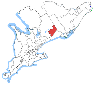
Haliburton—Kawartha Lakes—Brock is a federal electoral district in central Ontario, Canada, that has been represented in the House of Commons of Canada since 1968.
Norland is a small rural community located within the city of Kawartha Lakes, in the Canadian province of Ontario. It is located in a scenic spot on the Gull River at the north end of Shadow Lake, the northernmost Kawartha lake in the Trent River chain. Here, a series of three waterfalls reflect the change in elevation of the land leading north to the Haliburton Highlands.

Bowmanville is a town of approximately 40,000 people located in the Municipality of Clarington, Durham Region, Ontario, Canada. It is approximately 75 km (47 mi) east of Toronto, and 15 km (9.3 mi) east of Oshawa along Highway 2. Bowmanville was first incorporated as a town in 1858, but later incorporated with the neighbouring townships of Clarke and Darlington in 1974 forming the Town of Newcastle, which was renamed in 1994 to the Municipality of Clarington. Bowmanville is part of the Greater Toronto Area.
Durham County is a historic county in Ontario, Canada. It was named for the English County Durham and city of Durham. The County was created in 1792 although was later merged Northumberland County to form the United Counties of Northumberland and Durham. In 1974, the two counties were split and reorganized, with the former portions of Durham County reorganized into the Regional Municipality of Durham.
Peterborough—Kawartha is a federal electoral district in Ontario, Canada, that has been represented in the House of Commons of Canada since 1953. Prior to the 2015 election, the riding was known as Peterborough.

Courtice is a community in Ontario, Canada, about 60 km (37 mi) east of Toronto, adjacent to Oshawa and west of Bowmanville in the Municipality of Clarington. Courtice Road connects with Highway 401 at Interchange 425, providing arterial access to the community. Darlington Provincial Park is located just south of Courtice.
The Durham District School Board (DDSB), known as English-language Public District School Board No. 13 prior to 1999, is an Anglophone, secular public school board in Ontario, Canada. The DDSB serves most of the Regional Municipality of Durham, except for schools within the Municipality of Clarington, which belongs to the Kawartha Pine Ridge District School Board. The Durham District School Board Education Centre head office is in Whitby.

Pleasant View is a neighbourhood in the city of Toronto, Ontario, Canada that is located in the district of North York at the northern end of the city. It is bordered by Victoria Park to the East, Sheppard Avenue to the South, Highway 404 to the west and the Finch hydro corridor to the north. The neighbourhood is home to several high-rise apartment and condominium buildings, such as The Clippers.

Conseil scolaire catholique MonAvenir is a Roman Catholic French first language public-separate school board that manages elementary and secondary schools in the Greater Golden Horseshoe. The school board operates 46 elementary schools, 11 secondary schools, and two combined institutions within that area. Conseil scolaire catholique MonAvenir is headquartered in the Centre d'éducation catholique Omer-Deslauriers in North York, Toronto, Ontario, Canada.
Pontypool is an unincorporated village within the southernmost part of the amalgamated city of Kawartha Lakes, Ontario.

The Township of Bexley was a municipality located in the northern half of the former Victoria County, now the city of Kawartha Lakes, in the Canadian province of Ontario.

The Township of Mariposa was a municipality located in the southwest corner of the former Victoria County, now the city of Kawartha Lakes, in the Canadian province of Ontario. The other municipal neighbours of Mariposa are Ops and Fenelon on the east, Eldon on the north, Brock on the west, and Scugog on the south, with the latter two located in the Durham Regional Municipality. The former township includes the communities of Little Britain, Manilla, Mariposa, Valentia, and Oakwood. Today, most of the former township is represented in the City of Kawartha Lakes by the Ward 8 Councillor, John Pollard, and Ward 4 Councillor Andrew Veale.

The Township of Emily was a municipality located in the south-eastern corner of the former Victoria County, now the city of Kawartha Lakes, in Ontario, Canada.
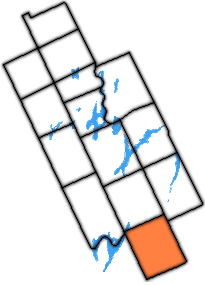
The Township of Manvers was a municipality in the former Victoria County, now the city of Kawartha Lakes, in the Canadian province of Ontario.

The Township of Verulam was a rural municipality within the former Victoria County, now the city of Kawartha Lakes. It was bounded on the north by the geographic township of Somerville, the south by the geographic township of Emily, the west by the geographic township of Fenelon, and the east by the County of Peterborough. For the purposes of government, land suryeying and reference, it is now properly referred to as the "Geographic Township of Verulam".
Haliburton—Kawartha Lakes—Brock is a provincial electoral district in Central Ontario, Canada. It elects one member to the Legislative Assembly of Ontario.
Peterborough—Kawartha is a provincial electoral district in Ontario, Canada, that has been represented in the Legislative Assembly of Ontario since 1934.
