
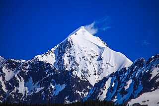
Pioneer Peak is a 6,398-foot (1,950 m) mountain in the Chugach Mountains in the U.S. state of Alaska. Located beside the Knik River just nine miles (14.5 km) south of Palmer and about six miles outside the Municipality of Anchorage limits, it is a prominent landmark in the Matanuska-Susitna Valley, as well as a popular hiking destination. Its Ahtna name means "the object is standing still" and its Dena'ina name means "the one that watches us". The name was given in 1939 in honor of the pioneers of the Matanuska agricultural colony of the mid-1930s. The Pioneer Ridge Trail leads up the eastern shoulder, beginning below 200', it allows access to the South summit. The North summit, and true summit of Pioneer Peak does not have a trail, and advanced mountaineering techniques are required. The first ascent of this peak was made June 1936 by Vernon Haik and John Wolffe via the Northwest Face.

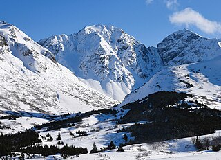
The Mitre is a 6,651-foot (2,027 m) mountain summit located in the western Chugach Mountains, in Anchorage Municipality in the U.S. state of Alaska. The mountain is situated in Chugach State Park, 30 mi (48 km) east of Anchorage, three miles (4.8 km) northeast of Bellicose Peak, and 5.5 mi (9 km) south-southeast of Eklutna Lake. The nearest higher peak is Benign Peak, 2.4 mi (4 km) to the west-northwest, on the opposite side of the Eklutna Glacier. Although modest in elevation, relief is significant since the western aspect of the mountain rises 4,000 feet above this glacier in approximately half a mile. In Europe, "mitre" is the term used for a sharp, symmetrical rocky peak such as this one. The Mitre's descriptive name was submitted for consideration by the Mountaineering Club of Alaska as suggested by Dr. Rodman Wilson (1921–2003) of Anchorage after he returned from a European vacation. The Mitre name was officially adopted in 1966 by the U.S. Board on Geographic Names. In the Denaʼina language, this mountain is known as Idlu Bena Dghelaya, meaning Mountain of Plural Objects Lake.

Calliope Mountain is a 6,821-foot (2,079 m) mountain summit located in the Chugach Mountains, in Anchorage Municipality in the U.S. state of Alaska. Calliope Mountain is situated in Chugach State Park, 20 mi (32 km) east-southeast of downtown Anchorage, and 2.1 mi (3 km) southwest of Eagle Peak, which is its nearest higher neighbor. The first ascent of the peak was made June 24, 1967, by W.E. Hauser and B.P. Hansen, who proposed naming it "Icy Peak", but their fellow members at the Mountaineering Club of Alaska persuaded them to adopt a more distinctive name that would be in keeping with the music theme of the immediate area. Within three miles of the peak there is a Symphony Lake, Concerto Peak, Flute Peak, Triangle Peak, Organ Mountain, Cantata Peak, and Hurdygurdy Mountain. The mountain's calliope name was officially adopted in 1969 by the U.S. Board on Geographic Names.
Tail Feather Peak is a 4,960-foot-elevation (1,512-meter) mountain summit in the U.S. state of Alaska. This mountain is located 14 miles (23 km) southeast of Anchorage in the Chugach Mountains and Chugach State Park. Precipitation runoff from the mountain drains into Ship Creek, thence Knik Arm. Topographic relief is significant as the summit rises 2,560 feet (780 m) in 0.75 mile (1.2 km) on the west slope. This mountain's toponym has not been officially adopted by the U.S. Board on Geographic Names.

Birds Eye Peak is a 4,970-foot-elevation (1,515-meter) mountain summit in the U.S. state of Alaska. This mountain is located 15 miles (24 km) southeast of Anchorage in the Chugach Mountains and Chugach State Park. Precipitation runoff from the mountain drains north to Knik Arm via Ship Creek and south to Turnagain Arm via Bird Creek. Topographic relief is significant as the summit rises 3,970 feet (1,210 m) above Bird Creek in less than two miles (3.2 km). This mountain's toponym has not been officially adopted by the U.S. Board on Geographic Names.

Whitecrown is a 6,390-foot (1,948 m) mountain summit in the U.S. state of Alaska.

Bellicose Peak is a 7,640-foot (2,329 m) mountain summit in Alaska, United States.

Rook Mountain is a 6,685-foot-elevation (2,038-meter) mountain summit in Alaska, United States.

Mount Yukla is a 7,569-foot (2,307 m) mountain summit in Alaska, United States.

Tiehacker Mountain is a 4,435-foot-elevation (1,352-meter) mountain summit in Alaska, United States.
Hearth Mountain is a 6,182-foot-elevation (1,884-meter) mountain summit in Alaska, United States.

Finland Peak is a 9,405-foot (2,867 m) elevation mountain summit in the U.S. state of Alaska.

Alabaster Peak is an 8,065-foot-elevation (2,458-meter) mountain summit located 35 miles (56 km) east of Palmer, in the northern Chugach Mountains of Alaska. This peak of the Matanuska Valley is set midway between Anchorage and Glennallen, and can be seen from the Glenn Highway. It is situated 15 miles (24 km) west of Matanuska Glacier and 1.8 miles (2.9 km) south of Awesome Peak. Precipitation runoff from the mountain drains into Coal, Monument, and Gravel creeks, which are tributaries of the Matanuska River. Topographic relief is significant as the summit rises 3,065 feet along the west slope in one mile (1.6 km). The first ascent of the summit was made on July 4, 1970, by Robert Spurr, Bob Pelz, and Royce Purinton via the Spectrum Glacier and North Ridge. This mountain's toponym has not been officially adopted by the United States Board on Geographic Names, so it is only marked as "8065" on USGS maps.
Peril Peak is a 7,040-foot (2,146 m) mountain summit in Alaska, United States.

Ice Cream Cone Mountain is an 8,675-foot-elevation (2,644-meter) mountain summit located 22 miles (35 km) east of Palmer, in the northern Chugach Mountains of Alaska. This peak is visible from the Glenn Highway near Mile 70 west of Kings Mountain. Precipitation runoff from the mountain's north slope drains into Carpenter Creek, a tributary of the Matanuska River, whereas the south slope drains into Metal Creek, a tributary of the Knik River. Topographic relief is significant as the summit rises 5,200 feet above Metal Creek in 1.5 mile (2.4 km) and 5,675 feet above Carpenter Creek in 1.9 mile (3 km). The first ascent of the summit was made on July 3, 1967, by David P. Johnston, John Samuelson, and Hans Van der Laan via the Northeast Ridge. This mountain's local descriptive toponym has not been officially adopted by the United States Board on Geographic Names, so it is only marked as "8675" on USGS maps. Some climbers in Anchorage call this peak the "Sky Buster" which was the name applied by mountaineer Vin Hoeman.

Whiteout Peak is a 7,135-foot (2,175 m) mountain summit in the U.S. state of Alaska.

Blacktail Ptarmigan Rocks is a 4,448-foot (1,356 m) mountain in the U.S. state of Alaska.

Troublemint Peak is a 6,801-foot-elevation (2,073-meter) summit in Alaska, United States.

Spearmint Spire is a 6,750-foot-elevation (2,057-meter) summit in Alaska, United States.

Higher Spire is a 6,135-foot-elevation (1,870-meter) summit in Alaska, United States.

