Villaviciosa | |
---|---|
Municipality of Villaviciosa | |
![]() View from the Palayan View Deck | |
![]() Map of Abra with Villaviciosa highlighted | |
Location within the Philippines | |
Coordinates: 17°26′N120°38′E / 17.44°N 120.63°E | |
Country | Philippines |
Region | Cordillera Administrative Region |
Province | Abra |
District | Lone district |
Barangays | 8 (see Barangays) |
Government | |
• Type | Sangguniang Bayan |
• Mayor | Jose W. Lagen Jr. |
• Vice Mayor | Marjorie L. Lagen |
• Representative | Menchie B. Bernos |
• Municipal Council | Members |
• Electorate | 4,302 voters (2025) |
Area | |
• Total | 102.93 km2 (39.74 sq mi) |
Elevation | 325 m (1,066 ft) |
Highest elevation | 667 m (2,188 ft) |
Lowest elevation | 126 m (413 ft) |
Population (2024 census) [3] | |
• Total | 5,674 |
• Density | 55/km2 (140/sq mi) |
• Households | 1,367 |
Economy | |
• Income class | 5th municipal income class |
• Poverty incidence | 19.1 |
• Revenue | ₱ 547.3 million (2022) |
• Assets | ₱ 1,028 million (2022) |
• Expenditure | ₱ 422.3 million (2022) |
• Liabilities | ₱ 35.95 million (2022) |
Service provider | |
• Electricity | Abra Electric Cooperative (ABRECO) |
Time zone | UTC+8 (PST) |
ZIP code | 2811 |
PSGC | |
IDD : area code | +63 (0)74 |
Native languages | Itneg Atta Ilocano Tagalog |
Villaviciosa, officially the Municipality of Villaviciosa (Ilocano : Ili ti Villaviciosa; Maeng Itneg : Ili di Villaviciosa; Tagalog : Bayan ng Villaviciosa), is a municipality in the province of Abra, Philippines. According to the 2020 census, it has a population of 5,675 people. [5]
The town is known for the Kimkimay Lake, a reminder of the wrath of the gods against people who have numerous vices. [6]
During the Spanish era, Villaviciosa was once called 'Kalaw', which was derived from its first settler, 'Agcalaw', who was from Ananaaw (now Gregorio del Pilar, Ilocos Sur). [7]
In 1904, Villaviciosa was separated from the town of Pilar, and eventually became a municipality in 1917. During World War II, on 8 December 1941, the people of Villaviciosa evacuated from the town towards the hinterlands. Sometime in December 1942, Japanese forces arrived in the town and ordered everyone to return to their homes. However guerrilla activity remained prevalent. By 1944, almost all men had joined the resistance against the Japanese. In one incident, Japanese forces were ambushed at a bridge near the south of the town, which then led to harsh Japanese reprisals against the innocent civilians. [7]
According to the Philippine Statistics Authority, the municipality has a land area of 102.93 square kilometres (39.74 sq mi) [8] constituting 2.47% of the 4,165.25-square-kilometre- (1,608.21 sq mi) total area of Abra. Villaviciosa is located at 17°26′N120°38′E / 17.44°N 120.63°E .
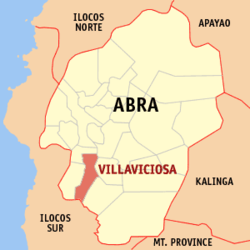
The municipality is geographically situated at the southern portion of Abra, bounded in the north-west by San Isidro, north by Bucay, east by Manabo and Luba, south by San Emilio, and west by Pilar.
The town is accessible from Benguet by land transportation through the Abra-Ilocos Sur Road , the more frequently used route. From the nearby Province of Ilocos Sur, it is also accessible through the Candon via San Emilio to Luba‑Tamac, Villaviciosa Road and the Santa Maria‑ Burgos via Pilar‑Villaviciosa Road.
Villavicios is situated 22.42 kilometres (13.93 mi) from the provincial capital Bangued, and 428.27 kilometres (266.11 mi) from the country's capital city of Manila.
Climate data for Villaviciosa, Abra | |||||||||||||
---|---|---|---|---|---|---|---|---|---|---|---|---|---|
Month | Jan | Feb | Mar | Apr | May | Jun | Jul | Aug | Sep | Oct | Nov | Dec | Year |
Mean daily maximum °C (°F) | 29 (84) | 30 (86) | 31 (88) | 33 (91) | 31 (88) | 30 (86) | 29 (84) | 29 (84) | 29 (84) | 30 (86) | 30 (86) | 29 (84) | 30 (86) |
Mean daily minimum °C (°F) | 18 (64) | 18 (64) | 20 (68) | 22 (72) | 24 (75) | 24 (75) | 23 (73) | 23 (73) | 23 (73) | 21 (70) | 20 (68) | 18 (64) | 21 (70) |
Average precipitation mm (inches) | 10 (0.4) | 10 (0.4) | 14 (0.6) | 23 (0.9) | 80 (3.1) | 103 (4.1) | 121 (4.8) | 111 (4.4) | 119 (4.7) | 114 (4.5) | 39 (1.5) | 15 (0.6) | 759 (30) |
Average rainy days | 5.2 | 3.9 | 6.2 | 9.1 | 18.5 | 21.4 | 22.9 | 19.8 | 19.8 | 16.2 | 10.5 | 6.1 | 159.6 |
Source: Meteoblue [9] |
Villaviciosa is politically subdivided into 8 barangays. [10] Each barangay consists of puroks and some have sitios.
PSGC | Barangay | Population | ±% p.a. | |||
---|---|---|---|---|---|---|
2024 [11] | 2010 [12] | |||||
140127001 | Ap-apaya | 9.6% | 542 | 531 | 0.14% | |
140127002 | Bol-lilising | 5.0% | 283 | 294 | −0.27% | |
140127003 | Cal-lao | 16.6% | 940 | 931 | 0.07% | |
140127004 | Lap-lapog | 16.1% | 916 | 766 | 1.25% | |
140127005 | Lumaba | 9.8% | 558 | 552 | 0.08% | |
140127006 | Poblacion | 15.8% | 897 | 836 | 0.49% | |
140127007 | Tamac | 11.9% | 678 | 627 | 0.55% | |
140127008 | Tuquib | 15.2% | 861 | 840 | 0.17% | |
Total | 5,674 | 5,675 | 0.00% |
Year | Pop. | ±% p.a. |
---|---|---|
1918 | 1,621 | — |
1939 | 2,574 | +2.23% |
1948 | 2,474 | −0.44% |
1960 | 3,194 | +2.15% |
1970 | 4,006 | +2.29% |
1975 | 3,865 | −0.72% |
1980 | 3,933 | +0.35% |
1990 | 4,612 | +1.61% |
1995 | 4,634 | +0.09% |
2000 | 4,877 | +1.10% |
2007 | 5,147 | +0.75% |
2010 | 5,377 | +1.60% |
2015 | 5,392 | +0.05% |
2020 | 5,675 | +1.08% |
2024 | 5,674 | −0.00% |
Source: Philippine Statistics Authority [13] [14] [12] [15] [16] |
In the 2020 census, Villaviciosa had a population of 5,675. [17] The population density was 55 inhabitants per square kilometre (140/sq mi).
Poverty incidence of Villaviciosa
10 20 30 40 50 60 2000 45.79 2003 54.79 2006 49.70 2009 49.07 2012 39.16 2015 14.26 2018 19.93 2021 19.10 Source: Philippine Statistics Authority [18] [19] [20] [21] [22] [23] [24] [25] |
Villaviciosa, belonging to the lone congressional district of the province of Abra, is governed by a mayor designated as its local chief executive and by a municipal council as its legislative body in accordance with the Local Government Code. The mayor, vice mayor, and the councilors are elected directly by the people through an election which is being held every three years.
Position | Name |
---|---|
Congressman | Joseph Santo Niño B. Bernos |
Mayor | Jose W. Lagen Jr. |
Vice-Mayor | Marjorie L. Lagen |
Councilors | Nelson L. Piyo |
Edmundo B. Belmes | |
Nixon B. Belmes | |
Amelito M. Bagno | |
Ingrid B. Oca | |
Ernest G. Binnong | |
Elsie L. Bona | |
Tessie G. Paned | |
The Villaviciosa Schools District Office governs all educational institutions within the municipality. It oversees the management and operations of all private and public, from primary to secondary schools. [27]