
Chendamangalam is a small town and a panchayat in Paravur Taluk, Ernakulam district in the state of Kerala, India.

Wayanad is a district in the north-east of the Indian state of Kerala, with administrative headquarters at the municipality of Kalpetta. It is the only plateau in Kerala. The Wayanad Plateau forms a continuation of the Mysore Plateau, the southern portion of Deccan Plateau which links the Western Ghats with the Eastern Ghats. It is set high in the Western Ghats with altitudes ranging from 700 to 2,100 meters. Vellari Mala, a 2,240 m (7,349 ft) high peak situated on the trijunction of Wayanad, Malappuram, and Kozhikode districts, is the highest point in Wayanad district. The district was formed on 1 November 1980 as the 12th district in Kerala, by carving out areas from Kozhikode and Kannur districts. An area of 885.92 km2 in the district is forested. Wayanad has three municipal towns—Kalpetta, Mananthavady and Sulthan Bathery. There are many indigenous tribes in this area. The Kabini River, a tributary of Kaveri River, originates at Wayanad. Wayanad district, along with the Chaliyar valley in the neighbouring Nilambur in Malappuram district, is known for natural gold fields, which are also seen in other parts of the Nilgiri Biosphere Reserve. Chaliyar river, which is the fourth longest river of Kerala, originates on the Wayanad plateau. The historically important Edakkal Caves are located in Wayanad district.
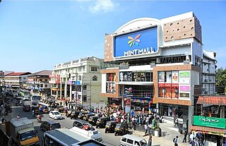
Sultan Bathery is a town and municipality in the Wayanad district of Kerala, India, near its borders with Tamil Nadu and Karnataka. Once known as a strategic location in the Malabar region, Sultan Bathery is the headquarters of the Sultan Bathery taluk.
Nelliyalam is a panchayat town in The Nilgiris district in the Indian state of Tamil Nadu. As of 2011, the town had a population of 44,590.
O' Valley or Ouchterlony Valley is a Town Panchayat in the Gudalur Taluk of The Nilgiris district in the Indian state of Tamil Nadu. The name is a contraction of an older name after a James Ouchterlony, who established coffee plantations in the area. This panchayat area is located between Mudumalai National Park and New Amarambalam Reserved Forest and has several valleys, streams and water falls.
Pandalur is a small town near Gudalur in the Pandalur taluk of Nilgiris district in Tamil Nadu, India.

Pulpally is a mid-sized town in Wayanad District of Kerala, India.Pulpally also known as 'The land of black gold'. Pulpally is also renowned for its pure wild Wayanad honey. The famous Seetha devi temple in Kerala is situated on Pulpally. Geographically a small town in Sultan Bathery Taluk and a "Grama Panchayath" under the local self governance system. It is about 24 km from Sultan Bathery, and is almost surrounded by forest. The main source of income is agriculture.
Kelakam is a small town and Grama Panchayat located in the south eastern part of Kannur district in Kerala state, India.

Devala is a town in the Nilgiris district of Tamil Nadu. It is situated at about 17 km from Gudalur on the Gudalur–Pandalur road. It is close to the Kerala-Tamil Nadu border, with Nilambur on the Kerala side.

Kaniyambetta or Pachilakkad is a village in the Wayanad district of Kerala state, southern India. It is about 8 km from the district capital Kalpetta.

Puthuppadi is a village and Panchayath located in Kozhikode district of Kerala, India. Puthuppadi Grama Panchayat covers an area of 64.75 km2 and is spread over the villages of Engapuzha and Puthuppadi. The panchayat is bounded on the north by Thamarassery, Kattippara, Kodenchery, Vythiri (Wayanad) panchayats, on the east by Vythiri (Wayanad) and Kodancheri panchayats, on the south by Thamarassery and Kodancheri panchayats and on the west by Kattippara panchayat. Famous Wayandan Churam or Wayandan Pass, which has nine hairpins between Adivaram of Puthuppady Panchayath and Lakkidi of Vythri Panchayath, is in Puthuppadi Panchayat.

Poothadi is a village near Kenichira, Panamaram area in Wayanad district in the state of Kerala, India.
Gudalur taluk is a taluk of Nilgiris district of the Indian state of Tamil Nadu. The headquarters of the taluk is the town of Gudalur.
Kundah taluk is a taluk of Nilgiris district of the Indian state of Tamil Nadu. The headquarters of the taluk is the town of Kundah and consists of seven revenue villages. Being Balacola, Kil Kundah, Mulligoor, Bikkatty, Kinnakorai, Ithalar and Mel Kundah.
Pandalur taluk is a taluk of Nilgiris district of the Indian state of Tamil Nadu. The headquarters of the taluk is the town of Pandalur.

Kallody is a village in the Edavaka Grama panchayath of the Wayanad district, Kerala, India. This village falls under the Mananthavady Taluk. The Hill Highway (Kerala) SH-59 passes through this village town.

Vythiri is a small village, town and tourist destination located in the Wayanad district in the Indian state of Kerala. It is one of the three Taluks in the district with the other two being Mananthavady and Sulthan Bathery.

Meenangadi is an old town situated on the highway NH 766 between Kalpetta and Sulthan Bathery in Wayanad District, in Kerala, India. This place is one among the Provinces where the existence of Dolmens provide an historical evidence of earlier civilisation. Coffee bean, Black pepper, Ginger, Rice and Areca are the major crops cultivated in this area. Meenangadi is famous for its Fish Market and Cattle Market. The nearest railway station is at Kozhikode at 87 km and airport is Kannur International Airport with 94 km from Meenangadi. Meenangadi is surrounded by, Ambalavayal Panchayat, Kalpetta Taluk towards west, Gudalur Taluk towards East, Mananthavady Taluk towards west. Kalpetta, Sultan Bathery, Kozhikode are the nearby Cities and towns to Meenangadi.
Kerala's first carbon neutrality project launched in Meenangadi in June 2016. Upon achieving the goals of the project, Meenangadi will be the first village in India to go completely carbon neutral. Meenangadi has a population of 33450 According to 2011 Census with two Villages Purakkadi and (Part)Krishnagiri.
The Wayanad District of Kerala, India has a wide variety of tourist attractions ranging from religious sites to natural, and historical sites. This district is divided into three towns, Kalpetta, Sultan Bathery and Mananthavady. All Major Tourism destinations in the district are maintained by the District Tourism Promotion Council.

Kayakkunnu is a village near Nadavayal, Mananthavady in the Wayanad District of Kerala, India. The village is part of the Panamaram Panchayath, and the assembly constituency is Mananthavady. It is an agricultural area and its main crops include rice, coffee, pepper, ginger, cardamom, vanilla, rubber, areca nut, and coconut. The nearest towns are Nadavayal and Panamaram. Kayakkunn is situated midway along the Mananthavady–Gudalur interstate road.

