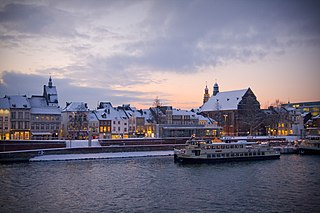
Maastricht is a city and a municipality in the southeastern Netherlands. It is the capital and largest city of the province of Limburg. Maastricht is located on both sides of the Meuse, at the point where the Jeker joins it. Mount Saint Peter (Sint-Pietersberg) is largely situated within the city's municipal borders. Maastricht is adjacent to the border with Belgium and is part of the Meuse-Rhine Euroregion, an international metropolis with a population of about 3.9 million, which includes the nearby German and Belgian cities of Aachen, Liège, and Hasselt.

The Meuse or Maas is a major European river, rising in France and flowing through Belgium and the Netherlands before draining into the North Sea from the Rhine–Meuse–Scheldt delta. It has a total length of 925 km.

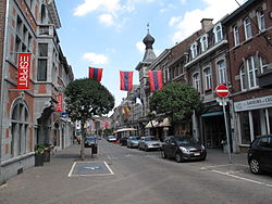
Roermond is a city, municipality, and diocese in the Limburg province of the Netherlands. Roermond is a historically important town on the lower Roer on the east bank of the river Meuse. It received town rights in 1231. Roermond's town centre has become a designated conservation area.

Liège is the easternmost province of the Wallonia region of Belgium.

Namur is a province of Wallonia, one of the three regions of Belgium. It borders on the Walloon provinces of Hainaut, Walloon Brabant, Liège and Luxembourg in Belgium, and the French department of Ardennes. Its capital and largest city is the city of Namur. As of January 2024, the province of Namur has a population of about 0.5 million.

Dinant is a city and municipality of Wallonia located in the province of Namur, Belgium. On the shores of river Meuse, in the Ardennes, it lies 90 kilometres (56 mi) south-east of Brussels, 30 kilometres (19 mi) south-east of Charleroi and 30 kilometres (19 mi) south of the city of Namur. Dinant is situated 20 kilometres (12 mi) north of the border with France.
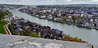
Namur is a city and municipality in Wallonia, Belgium. It is the capital both of the province of Namur and of Wallonia, hosting the Parliament of Wallonia, the Government of Wallonia and its administration.

Herstal, formerly known as Heristal, or Héristal, is a city and municipality of Wallonia located in the province of Liège, Belgium. It lies along the Meuse river. Herstal is included in the "Greater Liège" agglomeration, which counts about 600,000 inhabitants.

The Battle of Liège was the opening engagement of the German invasion of Belgium and the first battle of the First World War. The city of Liège was protected by a ring of modern fortresses, one of several fortified cities to delay an invasion to allow troops from the powers which had guaranteed Belgian neutrality to assist the Belgian Army in the expulsion of the invaders.
Fort Eben-Emael is an inactive Belgian fortress located between Liège and Maastricht, on the Belgian-Dutch border, near the Albert Canal, outside the village of Ében-Émael. It was designed to defend Belgium from a German attack across the narrow belt of Dutch territory in the region. Constructed in 1931–1935, it was reputed to be impregnable and at the time, the largest in the world.
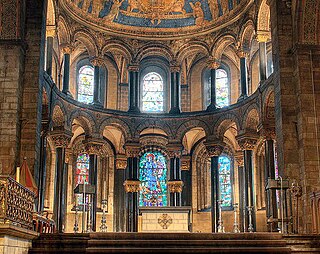
Mosan art is a regional style of art from the valley of the Meuse in present-day Belgium, the Netherlands, and Germany. Although in a broader sense the term applies to art from this region from all periods, it generally refers to Romanesque art, with Mosan Romanesque architecture, stone carving, metalwork, enamelling and manuscript illumination reaching a high level of development during the 11th, 12th and 13th centuries.
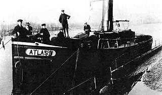
Atlas V was a Belgian tugboat which was armed by resistance forces, sailing under the command of Jules Hentjens during the First World War. On the night of 3 and 4 January 1917, the boat arrived in The Netherlands with 107 people aboard from Liège, Belgium, which was occupied by the German Empire.

Liège-Guillemins railway station is the main station in Liège, Belgium. It is one of the most important hubs in the country and is one of the four Belgian stations on the high-speed rail network. The station is used by 15,000 people every day, which makes it the eleventh-busiest station in Belgium and the third in Wallonia. It is operated by the National Railway Company of Belgium (SNCB/NMBS).

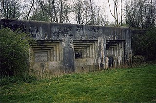
The fortified position of Liège was established after the First World War by Belgium to block the traditional invasion corridor through Belgium between Germany and France. In the First World War the Belgian Army held up the Germans for a week at Liège, delaying the German invasion of France, caused Belgium to consider a similar defensive strategy. Belgium rebuilt the Liège fortifications and extended them onto the Pays de Herve closer to Germany, using the most advanced fortification technology available.
Mount Saint Peter, also referred to as Caestert Plateau, is the northern part of a plateau running north to south between the valleys of the river Geer to the west, and the Meuse to the east. The plateau runs from Maastricht in the Netherlands, through Riemst in Belgian Limburg almost to the city of Liège in Belgium, thus defining the topography of this border area between Flanders, Wallonia and the Netherlands. The name of the hill, as well as the nearby village and church of Sint Pieter and the fortress of Sint Pieter, refers to Saint Peter, one of the Twelve Apostles.

The Belgian railway line 125 is a railway line in Belgium connecting Liège and Namur. Completed in 1851, the line runs 59.5 km. It runs along the northern (left) bank of the river Meuse.

The Siege of Namur was a battle between Belgian and German forces around the fortified city of Namur during the First World War. Namur was defended by a ring of modern fortresses, known as the Fortified Position of Namur and guarded by the 4th Division of the Belgian Army. The purpose of the fortified Belgian cities was to delay an invasion force until troops from the states guaranteeing Belgian independence came to their aid. The French Fifth Army planned to counter-attack while the Germans were besieging Namur.

The German atrocities of 1914 were committed by the Imperial German Army at the beginning of World War I in Belgium, particularly in Wallonia, and in France in the departments of Meuse, Ardennes, and Meurthe-et-Moselle.