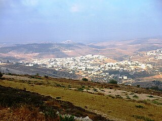
Nahalin, also spelled Nahaleen, is a Palestinian village located in the Bethlehem Governorate of the State of Palestine, to the southwest of Bethlehem in the West Bank. The village was well known for beekeeping and tens of beehives still exist in Nahalin today. The village is also known locally for its almond and olive trees, vineyards, parsley and vegetables, namely onions and beans. The built-up area of Nahalin consists of roughly 730 dunams, 20 of which make up the old center of the village. The village had a population of 8,741 in 2017.
Kafr 'Abbush is a Palestinian town in the Tulkarm Governorate in the northwestern West Bank. According to the Palestinian Central Bureau of Statistics, Kafr 'Abbush had a population of approximately 1,488 inhabitants in mid-year 2006 and 1,739 by 2017. 24.8% of the population of Kafr 'Abbush were refugees in 1997. The healthcare facilities for Kafr 'Abbush are based in Kafr 'Abbush, where the facilities are designated as MOH level 2.

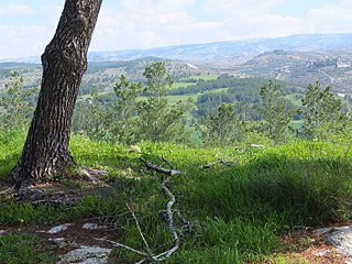
Wadi Fukin is a Palestinian village in the West Bank, eight kilometers southwest of Bethlehem in the Bethlehem Governorate. The village is located on 700 acres of land, between the Green Line and the Israeli West Bank barrier, with the Israeli settlement of Beitar Illit on one side and the Israeli town of Tzur Hadasa on the other. According to the Palestinian Central Bureau of Statistics, Wadi Fukin had a population of over 1,342 in 2017. The village relies on agriculture as its primary source of income. Israel served eviction orders on the village in September 2014.
Fasayil or Fasa'il, ancient Phasaelis, is a Palestinian village in the northeastern West Bank, a part of the Jericho Governorate, located 14 kilometres (8.7 mi) northwest of Jericho and about 40 kilometres (25 mi) southeast of Nablus. The closest Palestinian locality is Duma to the west. The village is located 2 km south of the Israeli settlement of Petza'el. According to the 2017 census by the Palestinian Central Bureau of Statistics (PCBS), the village had a population of 1,637.
Ras Atiya is a Palestinian town in the Qalqilya Governorate in the western area of the West Bank, located 27 km south of Tulkarm and 11 km south of Qalqiliya. According to the Palestinian Central Bureau of Statistics, the village had a population of 2,129 inhabitants in 2017.

Yasid is a Palestinian town in the Nablus Governorate in northern West Bank, located 15 kilometers northeast of Nablus. According to the Palestinian Central Bureau of Statistics (PCBS), the town had a population of 2,291 inhabitants in mid-year 2006 and 2,505 by 2017.
al-Mughayyir is a Palestinian village in the West Bank, located 12 km Southeast of the city of Jenin in the northern West Bank. According to the Palestinian Central Bureau of Statistics, the village had a population of 2,240 inhabitants in mid-year 2006 and 3,249 by 2017.
Al-Tayba is a Palestinian village in the West Bank, located 18 km northwest of the city of Jenin in the northern West Bank, and 2 km east of Umm el-Fahm in Israel. According to the Palestinian Central Bureau of Statistics, the town had a population of 2,386 inhabitants in mid-year 2006 and 2,215 in 2017.
Khirbet al-Deir, or Khirbet ed-Deir, is a Palestinian village located 10 kilometres (6.2 mi) southwest of Bethlehem, and 15 kilometres (9.3 mi) northwest of Hebron. The town is in the Hebron Governorate of central West Bank. According to the 2017 Palestinian Central Bureau of Statistics (PCBS) Census, the village had a population of 358 people.

Za'atara is a Palestinian town located 11 km (6.8 mi) southeast of Bethlehem. The town is in the Bethlehem Governorate central West Bank. According to the Palestinian Central Bureau of Statistics, the town had a population of over 7,849 in 2017. Founded by the at-Ta'mira Bedouin tribe, it is part of the 'Arab at-Ta'mira village cluster, along with Beit Ta'mir, Hindaza, Khirbet al-Deir, Tuqu', Nuaman, Ubeidiya and al-Asakra.

Al-Ubeidiya is a Palestinian town located 6 kilometers (3.7 mi) east of Bethlehem, in the Bethlehem Governorate of the State of Palestine, in the central West Bank. According to the Palestinian Central Bureau of Statistics (PCBS), al-Ubeidiya had a population of over 14,460 in 2017.

Tura al Gharbiya is a Palestinian town in the Jenin Governorate in the Northern area of the West Bank, located 14 kilometers West of Jenin close to the separation barrier. According to the Palestinian Central Bureau of Statistics, the town had a population of over 1,110 inhabitants in mid-year 2006 and 1,053 in 2017. The healthcare facilities for the surrounding villages are based in Tura al Gharbiya, the facilities are designated as MOH level 1.
al-Jarushiya is a Palestinian village in the Tulkarm Governorate in the western West Bank, located 6 kilometers North of Tulkarm. According to the Palestinian Central Bureau of Statistics, al Jarushiya had a population of 1,183 inhabitants in 2017. 8.4% of the population of al-Jarushiya were refugees in 1997. The healthcare facilities for the surrounding villages are based in al-Jarushiya, the facilities are designated as MOH level 2.
Nazlat 'Isa is a Palestinian village in the Tulkarm Governorate in the western West Bank, located 17 kilometres (11 mi) North of Tulkarm.
Saffarin is a Palestinian village in the western West Bank, in the Tulkarm Governorate of the State of Palestine, located 11 kilometers South-east of Tulkarm. According to the Palestinian Central Bureau of Statistics, Saffarin had a population of about 1,037 inhabitants in mid-year 2006 and 754 by 2017. 9.8% of the population of Saffarin were refugees in 1997. The healthcare facilities for Saffarin are designated as MOH level 2.

Shufa is a Palestinian village in the Tulkarm Governorate in the eastern West Bank, located 6 kilometers South-east of Tulkarm. According to the Palestinian Central Bureau of Statistics, Shufa had a population of approximately 1,253 inhabitants in mid-year 2006 and 1,350 by 2017. 5.4% of the population of Shufa were refugees in 1997. The healthcare facilities for Shufa are at Kafr al-Labad or Saffarin where the facilities are designated as MOH level 2.

as-Sawahira ash Sharqiya or Al-Sawahreh al-Sharqiyeh is a Palestinian town in the Jerusalem Governorate, located 6 kilometers south-east of East Jerusalem in the West Bank. According to the Palestinian Central Bureau of Statistics (PCBS), as-Sawahira ash Sharqiya had a population of 6,204 inhabitants in 2017. as-Sawahira ash Sharqiya shares the facilities, particularly schools and health amenities of the villages of Jabal Mukaber and ash-Sheikh Sa'd. The healthcare facilities for as-Sawahira ash Sharqiya are designated as Ministry of Health level 2.

Umm Salamuna is a Palestinian village located twelve kilometers south-west of Bethlehem. The village is in the Bethlehem Governorate in the southern West Bank. According to the Palestinian Central Bureau of Statistics, the village had a population of 1,188 in 2017. The primary healthcare is obtained in Beit Fajjar, where the Ministry of Health has classified the care facilities as level 3.
Marah Rabah is a Palestinian village located twelve kilometers south of Bethlehem. The village is in the Bethlehem Governorate central West Bank. According to the Palestinian Central Bureau of Statistics, the town had a population of over 1,729 in 2017. The primary healthcare is obtained in Tuqu', where the Ministry of Health denotes the healthcare facilities as level 2.
Nazlet Zeid is a Palestinian village in the northern West Bank, administratively part of the Jenin Governorate. The village is in Area C, putting it under full Israeli military and civilian control. The West Bank barrier runs through the village. According to the Palestinian Central Bureau of Statistics, the village had a population of 704 in the 2007 census and 843 in the 2017 census.

