Marah Rabah

Last updated
Marah Rabah
Arabic transcription(s)
Palestine location map wide.png
Red pog.svg
Marah Rabah
Location of Marah Rabah within Palestine
Coordinates: 31°38′06″N35°11′19″E / 31.63500°N 35.18861°E / 31.63500; 35.18861
State State of Palestine
Governorate Bethlehem
Government
  Type Municipality
Population
 (2017) [1]
  Total1,729

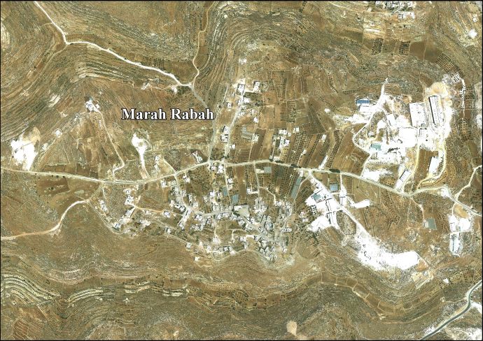
Marah Rabah is a Palestinian village located twelve kilometers south of Bethlehem. The village is in the Bethlehem Governorate central West Bank. According to the Palestinian Central Bureau of Statistics, the town had a population of over 1,729 in 2017. [1] The primary healthcare is obtained in Tuqu', where the Ministry of Health denotes the healthcare facilities as level 2. [2]

Contents

History

British Mandate era

In the 1931 census the population of Marah Rabah was counted together with Beit Fajjar, Marah Ma'alla and Umm Salamuna. The total population was 1,043, all Muslims, living in 258 houses. [3]

Jordanian era

In the wake of the 1948 Arab–Israeli War, and after the 1949 Armistice Agreements, Marah Rabah came under Jordanian rule. In 1961, the population of Murah Rabah was 198. [4]

Post 1967

Since the Six-Day War in 1967, Marah Rabah has been held under Israeli occupation.

Footnotes

  1. 1 2 Preliminary Results of the Population, Housing and Establishments Census, 2017 (PDF). Palestinian Central Bureau of Statistics (PCBS) (Report). State of Palestine. February 2018. pp. 64–82. Retrieved 2023-10-24.
  2. West Bank Healthcare facilities Archived 2006-03-13 at the Library of Congress Web Archives
  3. Mills, 1932, p. 35
  4. Government of Jordan, Department of Statistics, 1964, p. 23

Bibliography


Related Research Articles

<span class="mw-page-title-main">Husan</span> Municipality type C in Bethlehem, State of Palestine

Husan is a Palestinian town located 9 km (5.6 mi) west of Bethlehem, in the Bethlehem Governorate. According to the Palestinian Central Bureau of Statistics, Husan had a population of 7,048 in 2017.

<span class="mw-page-title-main">Al-Khader</span> Municipality type B in Bethlehem, State of Palestine

Al-Khader is a Palestinian town in the Bethlehem Governorate of the State of Palestine, in the south-central West Bank. It is located 5 kilometers (3.1 mi) west of Bethlehem. According to the Palestinian Central Bureau of Statistics, the town had a population of 11,960 in 2017. The area around al-Khader is marked by vineyards, and olive and fig trees.

<span class="mw-page-title-main">Surif</span> Municipality type A in Hebron, State of Palestine

Surif is a Palestinian City in the Hebron Governorate located 25 km northwest of the city of Hebron. According to the Palestinian Central Bureau of Statistics census, Surif had a population of 17,287 in 2011. The population is entirely Muslim.

<span class="mw-page-title-main">Beit Fajjar</span> Municipality type B in Bethlehem, State of Palestine

Beit Fajjar is a Palestinian town located eight kilometers south of Bethlehem in the Bethlehem Governorate, in the central West Bank. According to the Palestinian Central Bureau of Statistics, the town had a population of over 13,520 in 2017.

Qatanna is a Palestinian town in the central West Bank part of the Jerusalem Governorate, located 12 km. northwest of Jerusalem. According to the Palestinian Central Bureau of Statistics, the town had a population of 6,981 inhabitants in 2017. Primary health care for the town is level 2.

<span class="mw-page-title-main">Fasayil</span> Municipality type D in Jericho, State of Palestine

Fasayil or Fasa'il is a Palestinian village in the northeastern West Bank, a part of the Jericho Governorate, located 14 kilometres (8.7 mi) northwest of Jericho and about 40 kilometres (25 mi) southeast of Nablus. The closest Palestinian locality is Duma to the west. The village is located 2 km south of the Israeli settlement of Petza'el. According to the 2017 census by the Palestinian Central Bureau of Statistics (PCBS), the village had a population of 1,637.

<span class="mw-page-title-main">Qabalan</span> Municipality type C in Nablus, State of Palestine

Qabalan is a Palestinian town in the Nablus Governorate in the eastern West Bank, located 19 kilometers (12 mi) southeast of Nablus. According to the Palestinian Central Bureau of Statistics (PCBS), the town had a population of 8,195 inhabitants in 2017.

<span class="mw-page-title-main">Jab'a</span> Local Development Committee in Bethlehem, State of Palestine

Jab'a is a Palestinian village in the central West Bank, located 17 kilometers north of Hebron and 15 kilometers southwest of Bethlehem. Located three kilometers east of the Green Line, it is located in the Seam Zone, surrounded by the Israeli settlements in the Gush Etzion Regional Council and the Israeli West Bank barrier. Nearby Palestinian towns and villages include Surif adjacent to the Jaba'a, Wadi Fukin and Nahalin to the north. It is the northernmost locality in the Hebron Governorate. According to the Palestinian Central Bureau of Statistics, Jab'a had a population of approximately 1,121 in 2017. Jab'a has a total land area of 10,099 dunams, of which 1,002 dunams as built-up area.

<span class="mw-page-title-main">Qusin</span> Municipality type D in Nablus, State of Palestine

Qusin is a Palestinian town in the Nablus Governorate in northern West Bank, located 8 kilometers West of Nablus. According to the Palestinian Central Bureau of Statistics (PCBS), the town had a population of 2,251 inhabitants in 2017.

<span class="mw-page-title-main">Khirbet al-Deir</span> Municipality type D in Hebron, State of Palestine

Khirbet al-Deir, or Khirbet ed-Deir, is a Palestinian village located 10 kilometres (6.2 mi) southwest of Bethlehem, and 15 kilometres (9.3 mi) northwest of Hebron. The town is in the Hebron Governorate of central West Bank. According to the 2017 Palestinian Central Bureau of Statistics (PCBS) Census, the village had a population of 358 people.

<span class="mw-page-title-main">Za'atara</span> Municipality type C in Bethlehem, State of Palestine

Za'atara is a Palestinian town located 11 km (6.8 mi) southeast of Bethlehem. The town is in the Bethlehem Governorate central West Bank. According to the Palestinian Central Bureau of Statistics, the town had a population of over 7,849 in 2017.

Tarqumiyah is a Palestinian city located 12 kilometers northwest of Hebron, in the southern West Bank, in the Hebron Governorate of the State of Palestine. The city had a population of 19,311 in 2017.

Deir Sammit is a Palestinian town located eight kilometers west of Hebron. The town is in the Hebron Governorate Southern West Bank. According to the Palestinian Central Bureau of Statistics, the town had a population of 8,114 in 2017.

Ar-Rihiya is a Palestinian town located six kilometers southwest of Hebron. The town is in the Hebron Governorate southern West Bank. According to the Palestinian Central Bureau of Statistics, the town had a population of over 5,754 in 2017.

as-Sawahira ash Sharqiya or Al-Sawahreh al-Sharqiyeh is a Palestinian town in the Jerusalem Governorate, located 6 kilometers south-east of East Jerusalem in the West Bank. According to the Palestinian Central Bureau of Statistics (PCBS), as-Sawahira ash Sharqiya had a population of 6,204 inhabitants in 2017. as-Sawahira ash Sharqiya shares the facilities, particularly schools and health amenities of the villages of Jabal Mukaber and ash-Sheikh Sa'd. The healthcare facilities for as-Sawahira ash Sharqiya are designated as Ministry of Health level 2.

<span class="mw-page-title-main">Umm Salamuna</span> Municipality type D in Bethlehem, State of Palestine

Umm Salamuna is a Palestinian village located twelve kilometers South-west of Bethlehem. The village is in the Bethlehem Governorate in the southern West Bank. According to the Palestinian Central Bureau of Statistics, the village had a population of 1,188 in 2017. The primary healthcare is obtained in Beit Fajjar where the Ministry of Heath have classified the care facilities as level 3.

al-Kum Municipality type D in Hebron, State of Palestine

Al-Kum is a Palestinian village in the southern West Bank, part of the Hebron Governorate and located 13 kilometers west of Hebron. Its municipal borders stretch from the border with Israel in the west to boundaries of the city of Dura in the east. It had a population of 1,464 in the 2017 census by the Palestinian Central Bureau of Statistics.

Deir Razih is a Palestinian village in the southern West Bank located 11 kilometers (6.8 mi) southwest of Hebron, in the Hebron Governorate. It relies mainly on nearby Dura for basic services. Its total land area is made of 540 dunams, including its built-up area. The village had a population of 294 residents in 2017.

<span class="mw-page-title-main">Rabud</span> Municipality type D in Hebron, State of Palestine

Rabud is a Palestinian village in the southern West Bank, in the Hebron Governorate of the State of Palestine. The village was the site of an ancient Canaanite city. The village had a population of 2,816 in 2017.

At-Tira is a Palestinian village in the Ramallah and al-Bireh Governorate in the northern West Bank.