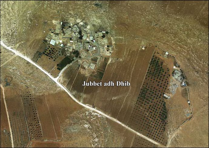
Jubbet ad-Dib

Last updated • 4 min readFrom Wikipedia, The Free Encyclopedia
Jubbet ad-Dib
Arabic transcription(s)
   Arabic جبة الذيب
   Latin Jubbet adh-Dhib (official)
Jub al-Dib (unofficial)
Palestine location map wide.png
Red pog.svg
Jubbet ad-Dib
Location of Jubbet ad-Dib within Palestine
Coordinates: 31°39′48″N35°14′54″E / 31.66333°N 35.24833°E / 31.66333; 35.24833
Palestine grid 173/119
State State of Palestine
Governorate Bethlehem
Founded1929
Government
  Type Local Development Committee
  Head of MunicipalityRiad Khamis [1]
Area
  Total402  dunams (0.4 km2 or 0.2 sq mi)
Population
 (2017) [2]
  Total144
  Density360/km2 (930/sq mi)
Name meaning"the Well of Wolves"

Jubbet ad-Dib (Arabic : جبة الذيب, also spelled Jubbet adh-Dhib) is a small Palestinian village in the central West Bank, part of the Bethlehem Governorate. It is located about 6.5 kilometers southeast of Bethlehem and is just east of the Palestinian town of Jannatah and north of the Israeli settlement Kfar Eldad. [3] Its lands border on the settlement of Havat Sdeh Bar. [4] It had a population of 144 according to the 2017 census by the Palestinian Central Bureau of Statistics (PCBS). [2] Jubbet ad-Dib has a total land area of 402 dunams, of which 8 constitute as built-up area, and is situated at an altitude of 628 meters above sea level. [3]

Contents

History

The village was established in 1929 by Bedouin Arabs who had previously lived and grazed their livestock there. [3] The inhabitants were part of the Bani Harb tribal confederation based in the Arabian Peninsula. [3] The village name translates as "the Well of the Wolves." Currently, Jubbet ad-Dib's population mostly belong to one clan, al-Wahsh. There is one mosque in the village, the Hamza Bin Abd al-Muttalib Mosque. [3]

The men of the village mainly work as construction labourers in Israel, and commuting through the Separation fence is time consuming, -rising at 3 a.m. and returning only in the evening, so that they are frequently absent during the working week. [4] Tired of waiting the women eventually organized their own solution. [4] In 2002 the Palestinian National Authority (PNA) established a five-member local development committee to administer Jubbet adh-Dhib. The PNA appoints all members and there is no headquarters for the committee in the village itself. [3] In recent years the village has relied on the leadership of the Women's Committee, which has successfully found international and donors of a school, a school bus, a solar heating system, and solar electricity, [5] [6] infrastructure which has also benefited from the aid and assistance of local NGOs, such as the Israel-Palestinian Comet-ME since 2016, and the Bimkom group of Israeli planners, who helped map the village confines. [4]

Economy and infrastructure

About 70% of Jubbet ad-Dib's employed workforce work in the Israeli labor market. The remainder largely work in agriculture. The unemployment rate in 2008 was 16%. [3] According to one elderly woman's memory, the villagers first asked to be linked up to a power grid in the 1970s, but in the end it required 40 years to get a connection. [4] According to a report by Human Rights Watch (HRW), Jubbet ad-Dib's local administration first applied to be connected to the Israeli electricity grid in 1988. Israeli authorities repeatedly denied the village electricity, as the village is under Israeli administrative control in "Area C." The village did not have paved roads connecting it to other Palestinian occupied localities. Children were required to walk down muddy tracks to get to a nearby school. [4] Residents cannot afford vehicles; most residents who need services walk for transportation. [7] By 2008, there were no schools or government institutions in the village, most services were provided by nearby towns such as Beit Ta'mir and Za'atara. [3]

The Netherlands eventually provided the funds for the solar power system. Three months after its installation, the Israel military government, together with the IDF confiscated the panels in late June 2017 on the grounds that they had been installed without an Israeli permit. The loss of the equipment, consisting of 96 solar panels and electronic equipment, resulted in the loss of electricity for the 30 families living in the village. The original donor, the Netherlands government, protested the confiscation [8] [9] and, after three months, in October, the equipment was returned. [4] [10] The Dutch later said they would continue projects to help Palestinians, with or without Israeli permission. [11] [4]

On 2a2 August 2017, six EU-donated steel cabins serving as a school in the area were demolished or removed along with school equipment by Israeli authorities on the day before school term started. [12] [13] This, and other destruction of Palestinian educational facilities by Israel, were condemned by France. [14] The school served 64 villager children, and a replacement structure was erected within days, successfully, by Bethlehem activists, despite an incursion by Israeli troops who attempted to use tear gas to disperse the workers. [15]

The model the women have developed has improved women's status in the village, and they are frequently called on for advice on broader regional problems of development. [4]

See also

Related Research Articles

<span class="mw-page-title-main">Abu Dis</span> Palestinian village in the West Bank

Abu Dis or Abu Deis is a Palestinian village in the West Bank, in the Jerusalem Governorate of the State of Palestine, bordering Jerusalem. Since the 1995 Oslo II Accord, Abu Dis land has been mostly part of "Area B", under Israeli military control and Palestinian civic control. According to the Palestinian Central Bureau of Statistics (PCBS) census, Abu Dis had a population of 12,251 in 2017.

Brukhin is an Israeli settlement located in the West Bank, about 1 km from the Palestinian city of Bruqin, whose lands were confiscated in order to construct Brukhin.

<span class="mw-page-title-main">Eli (Israeli settlement)</span> Israeli settlement in the West Bank

Eli is a large Israeli settlement in the West Bank organized as a community settlement, located on Highway 60, north of Ramallah, between the Palestinian villages of As-Sawiya and Qaryut, part of whose lands were expropriated for the establishment of Eli. The international community considers Israeli settlements in the West Bank illegal under international law, but the Israeli government disputes this.

<span class="mw-page-title-main">Salfit</span> Palestinian city in the West Bank

Salfit is a Palestinian city in the central West Bank, and the capital of the Salfit Governorate of the State of Palestine. Salfit is located at an altitude of 570 meters (1,870 ft), adjacent to the Israeli settlement of Ariel. According to the Palestinian Central Bureau of Statistics (PCBS), Salfit had a population of 10,911 in 2017. Since the 1995 Interim Agreement on the West Bank and the Gaza Strip, Salfit, located in Area A, has been administered by the Palestinian National Authority, while continuing under Israeli military occupation.

<span class="mw-page-title-main">Al-Khader</span> Municipality type B in Bethlehem, State of Palestine

Al-Khader is a Palestinian town in the Bethlehem Governorate of the State of Palestine, in the south-central West Bank. It is located 5 kilometers (3.1 mi) west of Bethlehem. According to the Palestinian Central Bureau of Statistics, the town had a population of 11,960 in 2017. The area around al-Khader is marked by vineyards, and olive and fig trees.

<span class="mw-page-title-main">Bruqin</span> Municipality type D in Salfit, State of Palestine

Bruqin is a Palestinian town 13 kilometers west of Salfit in the Salfit Governorate of the State of Palestine, in the northern West Bank, adjacent to the Israeli settlement of Brukhin, which was built over lands confiscated from the Palestinian town. According to the Palestinian Central Bureau of Statistics, Bruqin had a population of 4,047 in 2017. The town used to be on a camel-trading route. There is evidence of Roman rule in the city due to the presence of three ancient pools and a tomb.

<span class="mw-page-title-main">Wadi Fukin</span> Municipality type D in Bethlehem, State of Palestine

Wadi Fukin is a Palestinian village in the West Bank, eight kilometers southwest of Bethlehem in the Bethlehem Governorate. The village is located on 700 acres of land, between the Green Line and the Israeli West Bank barrier, with the Israeli settlement of Beitar Illit on one side and the Israeli town of Tzur Hadasa on the other. According to the Palestinian Central Bureau of Statistics, Wadi Fukin had a population of over 1,342 in 2017. The village relies on agriculture as its primary source of income. Israel served eviction orders on the village in September 2014.

<span class="mw-page-title-main">Deir al-Hatab</span> Municipality type D in Nablus, State of Palestine

Deir al-Hatab is a Palestinian village in the Nablus Governorate in the northern West Bank, located east of Nablus, near the neighbouring villages of Salem and Azmout. The village land extends over 12,000 dunams, of which 330 are built-up.

<span class="mw-page-title-main">Urif</span> Municipality type D in Nablus, State of Palestine

Urif is a Palestinian village in the Nablus Governorate of the State of Palestine, in the northern West Bank, located 13 kilometers south of Nablus. According to the Palestinian Central Bureau of Statistics (PCBS), the town had a population of 3,624 inhabitants in 2017.

ʿArab al-Jahalin also known as al-Jabal is a Palestinian Bedouin neighborhood in the Jerusalem Governorate, located five kilometers southeast of Jerusalem in the West Bank. According to the Palestinian Central Bureau of Statistics (PCBS), ʿArab al-Jahalin had a population of approximately 1,856 inhabitants in mid-year 2017. The village is situated on a hillside outside al-Eizariya and 300 meters away from the Jerusalem Municipal dump. It is located in Area C of the West Bank, with few parts is in Area B. While the Israeli government has full control over the village, the populace hold Palestinian IDs.

<span class="mw-page-title-main">Halamish</span> Israeli settlement in the West Bank

Halamish, also known as Neveh Tzuf, is an Israeli settlement in the West Bank, located in the southwestern Samarian hills to the north of Ramallah, 10.7 kilometers east of the Green line. The Orthodox Jewish community was established in 1977. It is organised as a community settlement and falls under the jurisdiction of Mateh Binyamin Regional Council. In 2022 it had a population of 1,590. On a hill within the settlement is Hovlata, an archeological site dating to the Hasmonean period.

<span class="mw-page-title-main">Nahliel</span> Israeli settlement in the West Bank

Nahliel is a Haredi Israeli settlement in the West Bank. Located close to the Palestinian villages of Beitillu and Deir 'Ammar, and some 20 kilometres (12 mi) from Modi'in, it is organised as a community settlement and falls under the jurisdiction of the Mateh Binyamin Regional Council. In 2022 it had a population of 743.

<span class="mw-page-title-main">Esh Kodesh</span> Place

Esh Kodesh is an Israeli outpost in the West Bank near Shilo. It falls under the jurisdiction of the Mateh Binyamin Regional Council. Israeli outposts in the West Bank are considered illegal both under international law as well as under Israeli law. The population in 2005 was under 12 families.

<span class="mw-page-title-main">Nabi Salih</span> Local Development Committee in State of Palestine

Nabi Salih is a small Palestinian village in the Ramallah and al-Bireh Governorate in the central West Bank, located 20 kilometers northwest of Ramallah. It had a population of 522 in 2017. It is noted for the weekly marches to protest the occupation undertaken since 2010, a practice suspended in 2016, after 350 villagers were estimated to have suffered injuries in clashes with Israeli troops over that period.

<span class="mw-page-title-main">Beit Ijza</span> Village in Jerusalem Governorate

Beit Ijza ; is a village in the Jerusalem Governorate in the central West Bank with an area of 2,526 dunams. Located approximately six miles north of Jerusalem, it had a population of 698 in 2007 and 854 by 2017.

<span class="mw-page-title-main">Jalud</span> Municipality type D in Nablus, State of Palestine

Jalud is a Palestinian village in the Nablus Governorate in the northern West Bank. It is approximately 30 kilometers (19 mi) south of Nablus and is situated just east of Qaryut, south of Qusra and northeast of Shilo, an Israeli settlement. Its land area consists of 16,517 dunams, 98 of which constitutes its built-up area. Jalud is encircled by four illegal outposts: Esh Kodesh, Adi Ad, Ahiya and Shvut Rachel. Jalud residents were blocked by both IDF forces and settlers from tending most of their farms from 2001 to 2007. In 2007 permission was given to farm their groves, twice a year for a few days, on condition that prior coordinating arrangements are made with the IDF.

Khirbet Zanuta is a Palestinian Bedouin village in the Hebron Governorate in the southern West Bank, located 20 kilometers south of Hebron. That was ethnically cleansed during the 2023 Israel-Hamas war. Some farmers remained or returned and the attacks continued. The location has previously been attacked in 2022. Settlers destroyed the vcillage school and most houses, and the IDF has refused to give its expelled residents permission to rebuild.

<span class="mw-page-title-main">Masafer Yatta</span> Palestinian villages south of Hebron, West Bank

Masafer Yatta is a collection of 19 Palestinian hamlets in the southern West Bank, in the Hebron Governorate of the State of Palestine, located between 14 and 24 kilometers south of the city of Hebron, in the southern Hebron Hills. The hamlets are situated within the municipal boundary of Yatta. The name "Masafer" is believed to derive from the Arabic words for "traveling," in light of the distance needed to travel from Yatta, or "nothing" in light of the local belief that "nothing" would be able to live in the area.

Umm al-Khair is a Palestinian village located in the Hebron Governorate of the State of Palestine, in the southern West Bank. It was inhabited by five families, roughly 70 people, in 2008. By 2017, the population of the village was 686.

<span class="mw-page-title-main">Renewable energy in Palestine</span>

Renewable energy in Palestine is a small but significant component of the national energy mix, accounting for 1.4% of energy produced in 2012. Palestine has some of the highest rate of solar water heating in the region, and there are a number of solar power projects. A number of issues confront renewable energy development; a lack of national infrastructure and the limited regulatory framework of the Oslo Accords are both barriers to investment.

References

  1. Jubbet adh-Dhib. Jerusalem Media and Communications Center.
  2. 1 2 Preliminary Results of the Population, Housing and Establishments Census, 2017 (PDF). Palestinian Central Bureau of Statistics (PCBS) (Report). State of Palestine. February 2018. pp. 64–82. Retrieved 2023-10-24.
  3. 1 2 3 4 5 6 7 8 Jubbet adh-Dhib Village Profile. Applied Research Institute-Jerusalem. 2008.
  4. 1 2 3 4 5 6 7 8 9 Netta Ahituv, 'What Happened When Palestinian Women Took Charge of Their Village,' Haaretz 7 May 2019
  5. 20 minutes from modern Jerusalem, a Palestinian village is stranded in the past, Anne-Marie O'Connor, October 22, 2016, The Washington Post
  6. Chloé Benoist, 'Palestinian women’s council takes charge: 'They depend on us',', Middle East Eye 26 October 2017.
  7. Separate and Unequal Israel's Discriminatory Treatment of Palestinians in the Occupied Palestinian Territories. Human Rights Watch. December 2010. pp.90-95.
  8. Amira Hass,'Dutch protest Israeli seizure of Palestinian solar panels they funded in West Bank. Netherlands' Foreign Ministry requested Israel return equipment it confiscated, valued at over 40,000 euro; Israel failed to hand out demolition orders in advance,' Haaretz 1 July 2017,
  9. Bethan McKernan, 'Israel seizes solar panels donated to Palestinians by Dutch government,' The Independent 3 July 2017.
  10. Amira Hass, 'Electricity returns to Palestinian village, three months after Israel confiscates power system. Each family in Jubbet Adh-Dhib village is allotted only three kilowatt hours per day as Israeli-Palestinian group reinstalls hybrid solar power system taken by Israel,', Haaretz 20 October 2017.
  11. Amira Hass, Netherlands says it will continue projects for Palestinians without Israel's OK, Haaretz 9 July 2017
  12. Bethan McKernan,'Israel destroys Palestinian classrooms ahead of first day of school,' The Independent 25 August 2017,
  13. Chloé Benoist, 'Torn down: Palestinian schools destroyed by Israel at start of new year,' Middle East Eye 24 August 2017.
  14. 'Palestinian Territories – Destruction of humanitarian structures,' Diplomatie France, 28 August 2017.
  15. 'Bethlehem: Activists rebuild Jubbet Ad-Dib School after Israel demolished it,' Middle East Monitor 10 September 2017