
Multnomah Falls is a waterfall located on Multnomah Creek in the Columbia River Gorge, east of Troutdale, between Corbett and Dodson, Oregon, United States. The waterfall is accessible from the Historic Columbia River Highway and Interstate 84. Spanning two tiers on basalt cliffs, it is the tallest waterfall in the state of Oregon at 620 ft (189 m) in height. The Multnomah Creek Bridge, built in 1914, crosses below the falls, and is listed on the National Register of Historic Places.

Taughannock Falls State Park is a 750-acre (3.0 km2) state park located in the town of Ulysses in Tompkins County, New York in the United States. The park is northwest of Ithaca near Trumansburg.

Wahkeena Falls is a 242-foot (74 m) waterfall in the Columbia River Gorge in the state of Oregon.
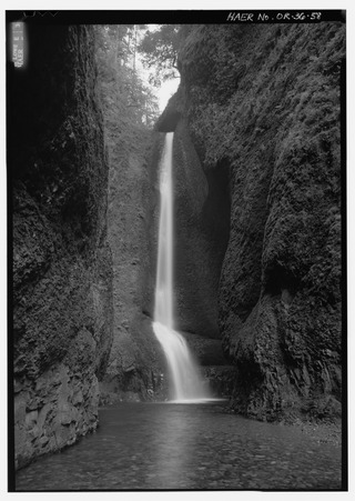
Oneonta Gorge is a scenic gorge located in the Columbia River Gorge area of the American state of Oregon. The U.S. Forest Service has designated it as a botanical area because of the unique aquatic and woodland plants that grow there. Exposed walls of 25-million-year-old basalt are home to a wide variety of ferns, mosses, hepatics, and lichens, many of which grow only in the Columbia River Gorge. Oneonta Gorge with its 50 species of wildflowers, flowering shrubs and trees has been described as "one of the true dramatic chasms in the state." The Oneonta Gorge Creek Bridge is listed on the National Register of Historic Places.

Rock Island State Park is a state park in Warren County and White County, Tennessee, located in the Southeastern United States. The park is named after the community of Rock Island, Tennessee, which in turn received its name from an island on the Caney Fork upstream from the Collins River confluence and Great Falls Dam. Rock Island State Park is centered on a peninsula created by the confluence of these two rivers and extends downstream to the headwaters of Center Hill Lake.

The Bridal Veil Falls is a waterfall located on Bridal Veil Creek along the Columbia River Gorge in Multnomah County, Oregon, United States. The waterfall is accessible from the historic Columbia River Highway and Interstate 84. Spanning two tiers on basalt cliffs, it is the only waterfall which occurs below the historic Columbia Gorge Scenic Highway. The Bridal Veil Falls Bridge, built in 1914, crosses over the falls, and is listed on the National Register of Historic Places.
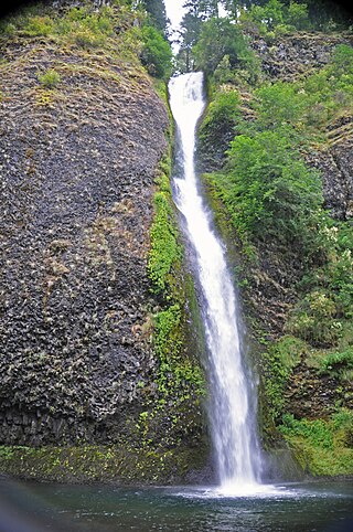
Horsetail Falls is a waterfall located on Horsetail Creek along the Columbia River Gorge in Multnomah County, in the U.S. state of Oregon. The falls drop over a cut over the columnar basalt cliff within the Oneonta Gorge. It is one of the waterfalls along the Columbia River Highway's waterfall corridor.

Latourell Falls is a waterfall along the Columbia River Gorge in the U.S. state of Oregon, within Guy W. Talbot State Park.
Eagle Creek is a creek located mainly in Hood River County, Oregon, in the Columbia River Gorge, with its last roughly 0.5 miles (0.80 km) and mouth in Multnomah County. A tributary of the Columbia River, the creek flows for approximately 15 miles (24 km) from the Thrush Pond between Eagle Butte and Tanner Butte to its mouth near Bonneville Dam. The East Fork Eagle Creek is a major tributary that begins at Wahtum Lake and joins the main stem approximately 2/3 the way between the Thrush Pond and the Columbia River, separated by Indian Mountain.

Larch Mountain is an extinct volcano near Portland, Oregon. The name is misleading, as no western larch can be found there. It received that name when early lumbermen sold the noble fir wood as larch. The peak can be reached between May and November on paved Larch Mountain Road, 16 mi (26 km) east of Corbett, Oregon, although the road is closed during the winter and spring months. The road leading to Larch Mountain from the Historic Columbia River Highway is 14 miles long, which closed at milepost 10 from Nov. through late May or early June due to snow.

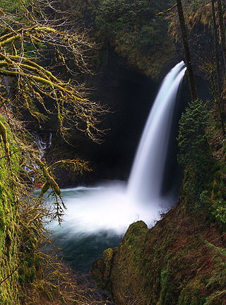
Wahclella Falls is a waterfall along Tanner Creek, a tributary of the Columbia River, Multnomah County, Oregon, United States. It enters the river within the Columbia River Gorge.
Metlako Falls is a waterfall on Eagle Creek in the Columbia River Gorge National Scenic Area in Hood River County, Oregon, United States. It is the furthest downstream of the major waterfalls on Eagle Creek. Like upstream Punch Bowl Falls, Metlako is also in the form of a punchbowl. The falls is 31 meters (101 ft) tall, though people have measured it anywhere from 30 to 46 m tall. It is the upstream limit for salmon spawning in Eagle Creek.
Multnomah Creek is a 5-mile-long (8.0 km) stream in northern Oregon. Multnomah Creek's source is on Larch Mountain in the Mount Hood National Forest and its waters flow north to the Columbia River Gorge, over Multnomah Falls into Benson Lake and then the Columbia River. The waterfall is accessible from the Historic Columbia River Highway and Interstate 84. The two drop waterfall is the tallest in the state of Oregon at 620 ft (189 m) in height.

Coopey Falls is a waterfall on Coopey Creek in the Columbia River Gorge, on the Historic Columbia River Highway in Multnomah County, Oregon. The falls is a horsetail waterfall with a drop of 150 feet (46 m).

Eagle Creek is a tributary of the Columbia River in Multnomah and Hood River counties in the U.S. state of Oregon. It cuts through a narrow canyon in its 3,200 feet (980 m) descent to the Columbia River Gorge and is known for its concentration of 13 waterfalls in about 5 miles (8.0 km) distance. Eight major falls are on Eagle Creek and the East Fork Eagle Creek itself, while five are on its tributaries.

Salt Creek Falls is a cascade and plunge waterfall on Salt Creek, a tributary of the Middle Fork Willamette River, that plunges into a gaping canyon in the Willamette National Forest near Willamette Pass in Lane County, Oregon. The waterfall is notable for its main drop of 286 feet (87 m), ranking third highest among plunge waterfalls in Oregon, after Multnomah Falls and Watson Falls.) The pool at the bottom of Salt Creek Falls waterfall is 66 feet (20 m) deep.

Double Falls, is a waterfall located in the Silver Falls State Park at the east end of the city of Salem, in Marion County, in the U.S. state of Oregon. It is located on the west foothills where Mount Hood National Forest meets with the Middle Santiam Wilderness. Several prominent waterfalls are located in the Park along Trail of Ten Falls: South Falls, Drake Falls, Middle North Falls, and Winter Falls—among others.

Wiesendanger Falls, also known as Double Falls and Twanklaskie Falls, is a 50-foot waterfall on the Columbia River Gorge, Multnomah County, Oregon, United States. Its main drop is 50 feet and is located upstream of Multnomah Falls and accessed through the Multnomah-Wahkeena Loop Hike.

Elowah Falls, also called McCord Creek Falls, is a 213-foot waterfall on the Columbia River Gorge, Multnomah County, Oregon, United States. Elowah Falls is one of several waterfalls along McCord Creek. The Creek and the waterfall are within the limits of the John B. Yeon State Scenic Corridor.
Tanner Creek is a creek located in the Columbia River Gorge in Multnomah County, Oregon, United States, that is a tributary of the Columbia River.
