Stuyvesant is a town in Columbia County, New York, United States. The population was 2,027 at the 2010 census. The town is in the northwest corner of Columbia County. U.S. Route 9 crosses the southeast corner of the town.

Brunswick is a town in Rensselaer County, New York, in the United States. The municipality was originally settled in the early 18th century. During its history, it had been part of Albany County, Rensselaerswyck, and Troy, before its incorporation in 1807. It is bordered on the west by the city of Troy; on the north by Schaghticoke and Pittstown; on the east by Grafton; and on the south by Poestenkill and North Greenbush. The population was 11,941 at the 2010 census. The source of the town's name is not certain, though some claim it comes from the source of its first inhabitants from the province of Brunswick-Lüneburg in Germany.

Hoosick is a town in Rensselaer County, New York, United States. The population was 6,924 at the 2010 census. It was named from the Hoosic River.

Hoosick Falls is a village in Rensselaer County, New York, United States. The population was 3,501 at the 2010 census. During its peak around 1900, the village had a population of about 7,000. The Capital District Regional Planning Commission projects a further decline in population through 2010 and beyond.

Pittstown is a town in Rensselaer County, New York, United States. The population was 5,735 at the 2010 census. It is in the northern part of the county.

North Bennington is an incorporated village in the town of Bennington in Bennington County, Vermont, United States. The population was 1,643 at the 2010 census.

Waterford is a town in Saratoga County, New York, United States. The population was 8,423 at the 2010 census. The name of the town is derived from its principal village, also called Waterford. The town is located in the southeast corner of Saratoga County and north-northwest of Troy at the junction of the Erie Canal and the Hudson River.

The Walloomsac River from the Native American name, Wal-loom-sac is a 16.8-mile-long (27.0 km) tributary of the Hoosic River in the northeastern United States. It rises in southwestern Vermont, in the Green Mountains east of the town of Bennington in Woodford Hollow at the confluence of Bolles Brook and City Stream where it is labeled Walloomsac Brook on maps but is locally known as "The Roaring Branch". The river then flows west toward Bennington and passes the downtown area to the north. For many years this section was intermittent due to the water having been diverted to power mills in town. This divergence gave the name Walloomsac to a portion of the river flowing through town on the present course of South Stream. The combined Walloomsac / South Stream joins the Roaring Branch northwest of town. From here the river flows westward as the Walloomsac River and joins the Hoosic River below Hoosick Falls, New York.

The Hoosic River, also known as the Hoosac, the Hoosick and the Hoosuck, is a 76.3-mile-long (122.8 km) tributary of the Hudson River in the northeastern United States. The different spellings are the result of varying transliterations of the river's original Algonquian name. It can be translated either as "the beyond place" or as "the stony place".

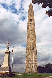
The Bennington Battle Monument is a 306-foot-high (93 m) stone obelisk located at 15 Monument Circle, in Bennington, Vermont, United States. The monument commemorates the Battle of Bennington during the American Revolutionary War.

This list is intended to be a complete compilation of properties and districts listed on the National Register of Historic Places in Rensselaer County, New York, United States. Seven of the properties are further designated National Historic Landmarks.

The Bronck House, also known as the Pieter Bronck House, is a historic house museum at 90 County Highway 42, west of Coxsackie in Greene County, New York. With a construction history dating to 1663, it is believed to be the oldest surviving building in Upstate New York, and is a well-preserved example of early Dutch and Swedish Colonial architecture. It was declared a National Historic Landmark in 1967. It is now a museum property managed by the county historical society.

The Bennington Battlefield is the Rensselaer County, New York, location where the Battle of Bennington occurred on the 16th of August 1777. It is located on New York State Route 67 in Walloomsac, New York, a historic route between Bennington, Vermont and the Hudson River. Here, New Hampshire, Vermont and Massachusetts militia under General John Stark rebuffed a British attempt led by Colonel Friedrich Baum to capture American stores. It was declared a National Historic Landmark in 1961. A portion of the battlefield is preserved in the Bennington Battlefield State Historic Site.

Buskirk Bridge is a wooden covered bridge and is the name of the hamlet in which it is located. It is in the town of Hoosick. The bridge, which crosses the Hoosic River is one of 29 historic covered bridges in New York State. The bridge takes its name from the nearby hamlet of the same name, which was named after the local Van Buskirk family.

Brunswick (Brittonkill) Central School District (BCSD) is a rural fringe central school district located east of the city of Troy whose main campus resides in the town of Brunswick in Rensselaer County, New York, United States. The district has two operating school buildings: Tamarac Elementary School and Tamarac Secondary School. The district is a member of the Rensselaer-Columbia-Greene Board of Cooperative Educational Services (BOCES), known as Questar III.

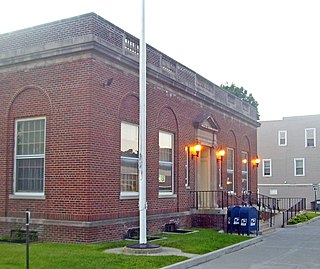
The U.S. Post Office in Hoosick Falls, New York, is located on Main Street a block south of downtown. It is a brick building erected in the mid-1920s, serving the 12090 ZIP Code, which covers the village of Hoosick Falls and surrounding portions of the Town of Hoosick.

The Hoosick Falls Historic District is located in the downtown section of the village of that name in New York, United States. It is an eight-acre (3.2-ha) area concentrated along Church, Classic and John streets south of the Hoosick River.

The Delaney Hotel, also the North Hoosick Hotel and Hathaway Hotel, is located at the junction of NY 22 and 67 in the hamlet of Hoosick, New York, United States. It is a large Greek Revival-style building dating to the middle of the 19th century with some later Italianate decoration. Few alterations have been made, and it is a well-preserved example of vernacular interpretations of those styles in a rural building.

The David Mathews House, also known as the State Line House, is a historic house straddling the state line on New York State Route 67 and Vermont Route 67 in Hoosick, New York and Shaftsbury, Vermont. Built about 1800, it is an imposing brick example of Federal architecture. The building is the subject of a number of tales, some of dubious authenticity. It was listed on the National Register of Historic Places in 1979.

North Hoosick is a hamlet in Rensselaer County, New York, United States. The community is located along the Walloomsac River at the intersection of New York State Route 22 and New York State Route 67, 1.9 miles (3.1 km) north of Hoosick Falls. North Hoosick has a post office with ZIP code 12133.


