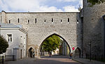
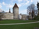
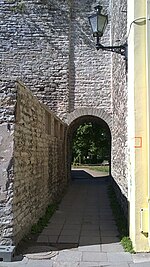
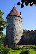
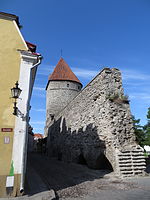
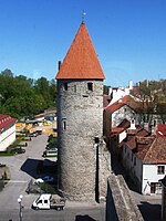
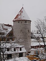
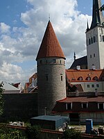
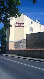
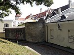
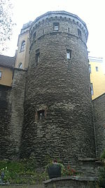
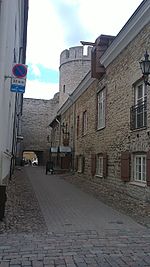
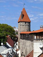
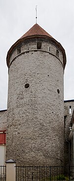
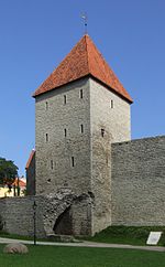
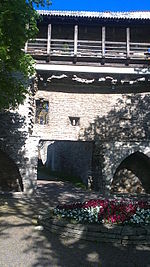
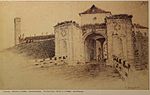
Walls of Tallinn

Last updated
Walls of Tallinn (Tallinn City Wall)
Native name
Tallinna linnamüür (Estonian)
Tornide valjak 2014.jpg
Tallinn City Wall
Location Tallinn, Estonia
Founded13th century
Built forDefense for the City of Tallinn
Architectural style(s) Medieval city wall
Official name Historic Centre (Old Town) of Tallinn
TypeCultural
Criteriaii, iv
Designated1997 (21st session)
Reference no.822
Europe and North America
http://whc.unesco.org/en/list/822

The Walls of Tallinn are the medieval defensive walls constructed around the city of Tallinn in Estonia.

Contents

History

The first wall around Tallinn was ordered to be constructed by Margaret Sambiria in 1265 resulting in its name, the 'Margaret Wall.' This wall was less than 5 metres (16 ft) tall and about 1.5 metres (4.9 ft) thick at its base. [1] Since that time it has been enlarged and strengthened. The walls and the many gates are still largely extant today. This is one of the reasons that Tallinn's old town became a World Heritage Site. The walls were enlarged in the fourteenth century, and citizens of Tallinn were required to turn out for guard duty, which meant to wear their armour and demonstrate their readiness to face invaders. [2]

Objects in the city wall

NameImageNotesLocationCoordinates
Long Leg Gate Tower
(Pika jala väravatorn)
Calle Pikk Jalg (Pierna larga), Tallin, Estonia, 2012-08-05, DD 03.JPG Pikk jalg 59°26′15.87″N24°44′34.33″E / 59.4377417°N 24.7428694°E / 59.4377417; 24.7428694 (Pika jala väravatorn)
Tower behind Almshouse
(Seegitagune torn)
demolished in the 19th centuryNunne 3
Tower behind Sauna
(Saunatagune torn)
Saunatagune torn2.jpg partially extantNunne 9 / Nunne 11A
Nun's Gate
(Nunnavärav)
Buddeus Nunnevarav.jpg Demolished in 1868.Nunne
Nun's Tower
(Nunnatorn)
Plaza de la Torre, Tallinn, Estonia, 2012-08-05, DD 16.JPG Väike-Kloostri 1 59°26′21.41″N24°44′32.55″E / 59.4392806°N 24.7423750°E / 59.4392806; 24.7423750 (Nunnatorn)
Monastery Gate
(Kloostrivärav)
Plaza de la Torre, Tallinn, Estonia, 2012-08-05, DD 32.JPG end of 19th centurySuur-Kloostri 59°26′22.01″N24°44′32.51″E / 59.4394472°N 24.7423639°E / 59.4394472; 24.7423639 (Kloostrivärav)
Sauna Tower
(Saunatorn)
Saunatorn, 23. juuli 2011.jpg Suur-Kloostri 18 59°26′22.63″N24°44′32.49″E / 59.4396194°N 24.7423583°E / 59.4396194; 24.7423583 (Saunatorn)
Golden Leg Tower
(Kuldjala torn)
Tallinn Town Wall Mai 2008 2.jpg Gümnaasiumi 1A 59°26′24.11″N24°44′33.25″E / 59.4400306°N 24.7425694°E / 59.4400306; 24.7425694 (Kuldjala torn)
Tower behind Nuns
(Nunnadetagune torn)
Plaza de la Torre, Tallinn, Estonia, 2012-08-05, DD 30.JPG Kooli 1 59°26′25.39″N24°44′34.27″E / 59.4403861°N 24.7428528°E / 59.4403861; 24.7428528 (Nunnadetagune torn)
Loewenschede Tower
(Loewenschede torn)
Plaza de la Torre, Tallinn, Estonia, 2012-08-05, DD 10.JPG Kooli 7 59°26′26.18″N24°44′35.99″E / 59.4406056°N 24.7433306°E / 59.4406056; 24.7433306 (Loewenschede torn)
Lippe Tower
(Lippe torn)
destroyedKooli 9
passage beside Lippe Tower Kaarkaik linnamuuris Lippe torni korval.JPG Built 1933Laboratooriumi 21 59°26′26.5″N24°44′38.85″E / 59.440694°N 24.7441250°E / 59.440694; 24.7441250 (passage)
Rope Hill Tower
(Köismäe torn)
All-linna kindlustused7.JPG Laboratooriumi 27 59°26′27.4″N24°44′41.67″E / 59.440944°N 24.7449083°E / 59.440944; 24.7449083 (Köismäe torn)
breakthrough of Suurtüki street Tallin city wall.jpg 19th centurySuurtüki 59°26′28.24″N24°44′43.48″E / 59.4411778°N 24.7454111°E / 59.4411778; 24.7454111 (breakthrough)
Plate Tower
(Plate torn)
Plate torn 2011-05-21.JPG Laboratooriumi 29 59°26′28.63″N24°44′43.98″E / 59.4412861°N 24.7455500°E / 59.4412861; 24.7455500 (Plate torn)
Epping Tower
(Eppingi torn)
Eppingi torn 2010-02-01.JPG Laboratooriumi 31 59°26′29.82″N24°44′46.2″E / 59.4416167°N 24.746167°E / 59.4416167; 24.746167 (Eppingi torn)
Tower behind Grusbeke
(Grusbeke-tagune torn)
Grusbeke-tagune torn 2010-08-11.JPG Laboratooriumi 33 59°26′31.22″N24°44′48.62″E / 59.4420056°N 24.7468389°E / 59.4420056; 24.7468389 (Grusbeke-tagune torn)
Renten Tower
(Renteni torn)
Renteni torn.jpg lower part extant inside a later buildingLai 49
Tower behind Wulfard
(Wulfardi-tagune torn)
Tallinn - Wulfgardi-tagune Tower.jpg lower part extantTolli 4 59°26′32.3″N24°44′53.97″E / 59.442306°N 24.7483250°E / 59.442306; 24.7483250 (Wulfgardi-tagune torn) }
Great Coastal Gate
(Suur Rannavärav)
Tallinn old town gate.jpg Pikk 70 59°26′33.23″N24°44′57.44″E / 59.4425639°N 24.7492889°E / 59.4425639; 24.7492889 (Suur Rannavärav)
Fat Margaret
(Paks Margareeta)
Fat Margrets Cannon Tower.jpg Pikk 70 59°26′33.3″N24°44′58.72″E / 59.442583°N 24.7496444°E / 59.442583; 24.7496444 (Paks Margareeta)
Stolting Tower
(Stoltingi torn)
Stoltingi torn 2013.jpg Pikk 68 59°26′31.78″N24°44′58.62″E / 59.4421611°N 24.7496167°E / 59.4421611; 24.7496167 (Stoltingi torn)
Tower behind Hattorpe
(Hattorpe-tagune torn)
Hattorpe-tagune torn.JPG Pikk 62 59°26′29.5″N24°44′57.6″E / 59.441528°N 24.749333°E / 59.441528; 24.749333 (Hattorpe-tagune torn)
tower near the former Russian churchdestroyedSulevimägi
Small Coastal Gate
(Väike Rannavärav)
destroyed
Bremen Tower
(Bremeni torn)
Bremeni torn 20081212 by Ahsoous.jpg Vene 28 59°26′21.86″N24°44′57″E / 59.4394056°N 24.74917°E / 59.4394056; 24.74917 (Bremeni torn)
Bremen Passage
(Bremeni käik)
Bremeni kaik.JPG 19th centuryBremeni käik 59°26′21.54″N24°44′57.15″E / 59.4393167°N 24.7492083°E / 59.4393167; 24.7492083 (Bremeni käik)
Tower behind Monks
(Munkadetagune torn)
Munkadetagune torn 2011-05-21.JPG Müürivahe 58 59°26′18.46″N24°44′58.89″E / 59.4384611°N 24.7496917°E / 59.4384611; 24.7496917 (Munkadetagune torn)
Helleman Tower
(Hellemani torn)
Calle Uus, Tallin, Estonia, 2012-08-05, DD 07.jpg Müürivahe 48 59°26′15.15″N24°44′59.82″E / 59.4375417°N 24.7499500°E / 59.4375417; 24.7499500 (Hellemanni torn)
Viru Gate
(Viru värav)
Viru Gate 1.jpg Viru 59°26′11.87″N24°45′1.31″E / 59.4366306°N 24.7503639°E / 59.4366306; 24.7503639 (Viru värav)
Hinke Tower
(Hinke torn)
Tallinn, vez.jpg Pärnu mnt 2 / Müürivahe 32 59°26′9.55″N24°44′57.98″E / 59.4359861°N 24.7494389°E / 59.4359861; 24.7494389 (Hinke torn)
Düvelsmoder Tower / Devil's Mother's Tower
(Düvelsmoderi torn / Kuradiema torn)
C Buddeus Kuradiema torn.jpg demolished in 1882Väike-Karja/Müürivahe
Lurenburg Artillery Tower
(Lurenburgi suurtükitorn)
Built 1538–1554, demolished in 1767 during the expansion of the bastion systems.Pärnu mnt 7
Cattle Gate
(Karjavärav)
Built 1456, demolished in 1849 to widen the streets. Was used to transport cattle between the city and pastures.
Assauwe Tower
(Assauwe torn)
Assauwe torn Myyrivahe tanaval, vaade Harju tanava poolt, 8. august 2011.jpg Müürivahe 12 59°26′5.61″N24°44′43.33″E / 59.4348917°N 24.7453694°E / 59.4348917; 24.7453694 (Assauwe torn)
Harju Gate
(Harju värav)
Harju varav, 1863.JPG
The main gate after the demolition of the front gates.
Mentioned in 1361, 1448–1453 the second front gate was built. In 1862 the front gates were demolished and in 1875 the main gate.Harju 59°26′4.74″N24°44′37.53″E / 59.4346500°N 24.7437583°E / 59.4346500; 24.7437583 (Harju värav)
Goat Tower
(Kitsetorn)
Rüütli
Kiek in de Kök Kiek in de kok 3015.jpg Komandandi tee 2 59°26′5.14″N24°44′29″E / 59.4347611°N 24.74139°E / 59.4347611; 24.74139 (Kiek in de Kök)
Maiden's Tower
(Neitsitorn)
Neitsitorn, Tallinn.JPG Lossi plats 11 / Lühike jalg 9A 59°26′6.8″N24°44′27.51″E / 59.435222°N 24.7409750°E / 59.435222; 24.7409750 (Neitsitorn)
Stable Tower
(Tallitorn)
OldCity GuardTowerPark.JPG Lossi plats 11 / Lühike jalg 9A 59°26′8.43″N24°44′26.91″E / 59.4356750°N 24.7408083°E / 59.4356750; 24.7408083 (Tallitorn)
breakthrough from Toompea to Danish King's Garden Varav linnamuuris Taani kuninga aeda.JPG Lühike jalg 59°26′8.9″N24°44′27.14″E / 59.435806°N 24.7408722°E / 59.435806; 24.7408722 (breakthrough)
Short Leg Gate Tower
(Lühikese jala väravatorn)
Luhikese Jala varavatorn.JPG Lühike jalg 9 59°26′10.01″N24°44′28.15″E / 59.4361139°N 24.7411528°E / 59.4361139; 24.7411528 (Lühikese jala väravatorn)
Dome Gate
(Toomvärav)
C Buddeus Toomvarav.jpg demolished in 1860.

Notes

  1. Andriy Ksenofontov, = Wall Street ... Estonian Times, 15 August 2002
  2. Bousfield, Jonathon (2011). The Rough Guide to Estonia, Latvia & Lithuania p.71. p. 392. ISBN   9781848368880.

Related Research Articles

<span class="mw-page-title-main">Tallinn Airport</span> Airport in Tallinn, Estonia

Tallinn Airport is the largest international airport in Estonia. The airport is also officially called Lennart Meri Tallinn Airport after the former president of Estonia Lennart Meri.

<span class="mw-page-title-main">Toompea</span> Hill in central Tallinn, Estonia

Toompea is a hill in the central part of Tallinn, the capital city of Estonia. The hill has an area of 7 hectares and is about 20–30 metres higher than the surrounding areas. Toompea is part of the medieval Tallinn Old Town, a UNESCO World Heritage Site.

<span class="mw-page-title-main">Yarlung Tsangpo Grand Canyon</span> Canyon in Tibet, China

The Yarlung Tsangpo Grand Canyon, also known as the Yarlung Zangbo Grand Canyon, the Tsangpo Canyon, the Brahmaputra Canyon or the Tsangpo Gorge, is a canyon along the Yarlung Tsangpo River in Tibet Autonomous Region, China. It is the deepest canyon in the world, and at 504.6 kilometres (313.5 mi) is slightly longer than the Grand Canyon in the United States, making it one of the world's largest. The Yarlung Tsangpo originates near Mount Kailash and runs east for about 1,700 kilometres (1,100 mi), draining a northern section of the Himalayas before it enters the gorge just downstream of Pei, Tibet, near the settlement of Zhibe. The canyon has a length of about 240 kilometres (150 mi) as the gorge bends around Mount Namcha Barwa and cuts its way through the eastern Himalayas. Its waters drop from about 2,900 metres (9,500 ft) near Pei to about 1,500 metres (4,900 ft) at the end of the Upper Gorge where the Po Tsangpo River enters. The river continues through the Lower Gorge to the Indian border at an elevation of 660 metres (2,170 ft). The river then enters Arunachal Pradesh and eventually becomes the Brahmaputra.

The Blue Mountains Dams are a series of six dams in the Blue Mountains which supply water to the Blue Mountains and Sydney, Australia. The Dams are managed by the WaterNSW. Water in this scheme may be supplemented from the Fish River Scheme.

<span class="mw-page-title-main">Los Molinos Dam</span> Dam in Córdoba

The Los Molinos Dam is a dam over the course of the Los Molinos River in the center-west of the province of Córdoba, Argentina, about 769 metres (2,523 ft) above mean sea level.

<span class="mw-page-title-main">Rubicon Hydroelectric Scheme</span> Hydroelectric scheme in Victoria, Australia

The Rubicon Hydroelectric Scheme is a small run-of-the-river hydroelectric scheme located on the Rubicon and Royston Rivers, north east of Melbourne, 40 km (25 mi) south-west of Alexandra, Victoria, Australia. The scheme commenced in 1922, and was the first state-owned hydroelectric scheme to generate electricity in mainland Australia, and among the first in the world to be remotely controlled. For the first ten years of its operation it supplied on average 16.9% of electricity generated by the State Electricity Commission of Victoria. It is now owned and operated by AGL Energy and contributes approximately 0.02% of Victoria's energy supply.

Gerad Wilwal Airport is a public airport serving Jijiga, the capital city of the Somali Region in eastern Ethiopia. The airport is located at 09°19′56″N42°54′43″E, which is 12 km east of the city. It is named after seventeenth-century jigjiga ruler Garad Wiil-Waal.

<span class="mw-page-title-main">Dagenham wind turbines</span>

The Dagenham wind turbines are two 85-metre (279 ft) high Enercon E-66 and one E-82 wind turbines located on the Dagenham estate of the Ford Motor Company in East London, England. The first two turbines were completed in April 2004 and the third was installed in 2011. They are landmarks of the skyline and the first wind farm to be built in London.

<span class="mw-page-title-main">Locks on the Canal du Midi</span>

There are 91 working locks on the Canal du Midi along its 240-kilometre (150 mi) course from the Bassin du Thau on the Mediterranean coast to the junction with the Canal lateral a la Garonne in Toulouse. There are a further 13 locks on the 37-kilometre (23 mi) La Nouvelle branch which runs through Narbonne to the Mediterranean at Port-la-Nouvelle. The locks are all under the management of the French navigation authority, Voies navigables de France.

The Turkwel Hydroelectric Power Station, also Turkwel Dam, is an arch dam on the Turkwel River about 76 km (47 mi) north of Lorokon in West Pokot County, Kenya. The dam serves several purposes, including hydroelectric power production, irrigation, tourism and fisheries. It was constructed between 1986 and 1991. It supports the third largest hydroelectric power plant in the country, having an installed electric capacity of 106 megawatts (142,000 hp).

Sund Rock is a designated conservation area on the U.S. state of Washington's Hood Canal. The area is known for abundant and diverse life, including but not limited to Lingcod, Giant Pacific Octopus, Wolf Eel, as well as nudibranch, anemone, and sea cucumber.

<span class="mw-page-title-main">Edinburgh town walls</span> City walls in City of Edinburgh, Scotland, UK

There have been several town walls around Edinburgh, Scotland, since the 12th century. Some form of wall probably existed from the foundation of the royal burgh in around 1125, though the first building is recorded in the mid-15th century, when the King's Wall was constructed. In the 16th century the more extensive Flodden Wall was erected, following the Scots' defeat at the Battle of Flodden in 1513. This was extended by the Telfer Wall in the early 17th century. The walls had a number of gates, known as ports, the most important being the Netherbow Port, which stood halfway down what is now the Royal Mile. This gave access from the Canongate which was, at that time, a separate burgh.

<span class="mw-page-title-main">Maarjamäe</span> Subdistrict of Tallinn, Estonia

Maarjamäe is a subdistrict in the district of Pirita, Tallinn, the capital of Estonia. It is bordered by Pirita and Kose to the north, Lasnamäe to the south, Kadriorg to the southwest and the Bay of Tallinn to the west. As of 2022, it has a population of 2,412.

<span class="mw-page-title-main">Goodenough Glacier</span> Glacier in Antarctica

The Goodenough Glacier is a broad sweeping glacier to the south of the Batterbee Mountains, flowing from the west shore of Palmer Land, Antarctica, into George VI Sound and the George VI Ice Shelf.

<span class="mw-page-title-main">Miel I Dam</span> Dam in Norcasia

The Miel I Dam, officially known as the Patángoras Dam, is a gravity dam on La Miel River just south of Norcasia in Caldas Department, Colombia. The dam was constructed between 1997 and 2002 for the primary purpose of hydroelectric power generation. At the time of its completion, the dam was the tallest roller-compacted concrete (RCC) dam in the world but was surpassed by the Longtan Dam in 2009.