Toompea Castle

Last updated
Toompea Castle
Toompea loss
Toompea loss 2014.jpg
Toompea castle in 2014
Tallinn map.png
Red pog.svg
Location within Tallinn.
General information
Town or city Tallinn
Country Estonia
Completed14th and 16th centuries
Toompea Castle
Toompea castle (2016)
Photo: Stefan Hiienurm Toompea Castle.jpg
Toompea castle (2016)
Photo: Stefan Hiienurm

Toompea castle (Estonian : Toompea loss) is a medieval castle on Toompea hill in the central part of Tallinn, the capital of Estonia. In modern times, it houses the Parliament of Estonia (Riigikogu). [1]

Contents

History

The Toompea castle's predecessor, an ancient Estonian stronghold had been in use since at least the 9th century AD. In 1219, the castle was taken over by Denmark's crusaders led by king Valdemar II. [1] According to a popular Danish legend, the flag of Denmark (Dannebrog) fell from the sky during a critical stage of the battle (known as the Battle of Lindanise). This first proper castle was referred to as the "Castle of the Danes", in Latin castrum danorum and in contemporary archaic Estonian taani linna. From the latter, the modern name of the city of Tallinn is possibly derived [2] (see also Tallinn § Etymology).

In 1227, the castle was taken over by the Order of the Brethren of the Sword, who initiated rebuilding schemes. The castle's reconstruction began in the 13th century and is to a large extent the castle that can be seen today. The castle again fell to Denmark just ten years later, in 1237, but was sold to the Teutonic Order in 1346, and would remain in their hands for the remainder of the Middle Ages. [1]

18th century, Baroque additions to the castle Gobierno de Estonia, Tallinn, Estonia, 2012-08-05, DD 02.JPG
18th century, Baroque additions to the castle

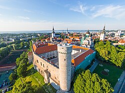
As the crusading Teutonic Order was a religious order, the castle came to resemble a monastery in several ways. It included a chapel, a chapter house and a dormitory for the knights. The order was also responsible for erecting the still visible towers of the castle, including "Pilsticker" (translated as "arrow-sharpener"), "Stür den Kerl" ("ward off the enemy"), "Landskrone" ("crown of the land"), and "Langer Hermann" (in Estonian Pikk Hermann or "Tall Hermann"). [1] Tall Hermann is 48 metres (157 ft) tall and dominates the castle skyline. The flag of Estonia is hoisted at the top of the tower every day at sunrise, to the sound of the national anthem, and lowered at sunset. [1]

After the Protestant Reformation and many wars that followed in the 16th century, the Teutonic Order lost its last possessions in Estonia and the region became contested by Sweden, Poland and Muscovy (Russia). By 1561, northern Estonia had become part of the Kingdom of Sweden. The Swedish rulers transformed the castle from a medieval fortress into a ceremonial and administrative centre of political power in Estonia, a purpose the castle has served ever since. [1]

In 1710, Sweden lost the territory of modern-day Estonia to the Tsardom of Russia. Subsequently a number of larger reconstruction schemes were carried out and the building complex was effectively turned from a castle into a palace. A new dominating wing in Baroque and Neoclassical style, designed by Johann Schultz, was added in the eastern part of the complex. It housed the provincial administration of the Governorate of Estonia and the living quarters of the imperial governor. In the 19th century, a public park was also created and to the south-east of the castle, and an archive building erected nearby. [1] [3]

Parliament building

Estonian parliament building which was constructed in 1922 Riigikogu sisehoov1.jpg
Estonian parliament building which was constructed in 1922
Session hall. Riigikogu (2011).jpg
Session hall.

After Estonia became independent in 1918, the government decided to build a new house for the nation's parliament ( Riigikogu ) at the site of the former convent building of the Teutonic Order. Taking two years to complete, the parliament building, designed by architects Eugen Habermann and Herbert Johanson, was finished in 1922. [3] Although its exterior is traditionalist, the interior is Expressionist in style - the world's only Expressionist parliament building. [1]

After June 1940, during the period of foreign occupations — by the Soviet Union until 1941, by Nazi Germany in 1941—1944, and then again by the Soviet Union after 1944 — the democratically elected parliament of Estonia was disbanded. The castle and the building of Riigikogu were however used by the local Supreme Soviet, the formal rubber stamp legislative body of Soviet-occupied Estonia without any substantive meaning, between 1947 and 1990.

According to a legend, recorded in the 19th century, the entire hill of Toompea was once upon a time created by a mythological heroine Linda who built it boulder-by-boulder with her own hands. [4]

See also

Related Research Articles

<span class="mw-page-title-main">Flag of Estonia</span>

The national flag of Estonia is a tricolour featuring three equal horizontal bands of blue at the top, black in the centre, and white at the bottom. The flag is called sinimustvalge in Estonian.

<span class="mw-page-title-main">Pikk Hermann</span> Tower in Tallinn

Pikk Hermann is a tower of the Toompea Castle, on Toompea (Domberg) hill in Tallinn (Reval), the capital of Estonia. The first part of the tower was built in 1360–1370. It was rebuilt in the 16th century. A staircase with 215 steps now leads to the top of the tower. It consists of ten internal floors and a viewing platform at the top.

<span class="mw-page-title-main">Toompea</span> Hill in central Tallinn, Estonia

Toompea is a hill in the central part of Tallinn, the capital city of Estonia. The hill has an area of 7 hectares and is about 20–30 metres higher than the surrounding areas. Toompea is part of the medieval Tallinn Old Town, a UNESCO World Heritage Site.

<span class="mw-page-title-main">Kuressaare</span> City in Estonia

Kuressaare is a town on the island of Saaremaa in Estonia. It is the administrative centre of Saaremaa Municipality and the seat of Saare County. Kuressaare is the westernmost town in Estonia. The recorded population on 1 January 2024 was 13,185.

<span class="mw-page-title-main">Harju County</span> County of Estonia

Harju County, is one of the fifteen counties of Estonia. It is situated in northern Estonia, on the southern coast of the Gulf of Finland, and borders Lääne-Viru County to the east, Järva County to the southeast, Rapla County to the south, and Lääne County to the southwest. The capital and largest city of Estonia, Tallinn, is situated in Harju County. Harju is the largest county in Estonia in terms of population, as almost half (45%) of Estonia's population lives in Harju County.

<span class="mw-page-title-main">Riigikogu</span> Unicameral parliament of Estonia

The Riigikogu is the unicameral parliament of Estonia. In addition to approving legislation, the Parliament appoints high officials, including the prime minister and chief justice of the Supreme Court, and elects the president. Among its other tasks, the Riigikogu also ratifies significant foreign treaties that impose military and proprietary obligations and bring about changes in law, as well as approves the budget presented by the government as law, and monitors the executive power.

<span class="mw-page-title-main">Coat of arms of Estonia</span>

The coat of arms of the Republic of Estonia is a golden shield which includes a picture of three left-facing blue lions with red tongues in the middle, with golden oak branches placed on both sides of the shield. The coat of armes was derived from the 13th century royal coat of arms of Denmark, as the Duchy of Estonia (1219–1346) in what now northern Estonia was part of Denmark at the time.

<span class="mw-page-title-main">Saint George's Night Uprising</span> 1343–45 rebellion in Danish-controlled Estonia

Saint George's Night Uprising in 1343–1345 was an unsuccessful attempt by the indigenous Estonian population in the Duchy of Estonia, the Bishopric of Ösel-Wiek, and the insular territories of the State of the Teutonic Order to rid themselves of Danish and German rulers and landlords who had conquered the country in the 13th century during the Livonian Crusade; and to eradicate the non-indigenous Christian religion. After initial success the revolt was ended by the invasion of the Teutonic Order. In 1346, the Duchy of Estonia was sold for 19,000 Köln marks by the King of Denmark to the Teutonic Order. The shift of sovereignty from Denmark to the State of the Teutonic Order took place on November 1, 1346.

<span class="mw-page-title-main">Duchy of Estonia (1219–1346)</span> Former Danish possession in Baltics

The Duchy of Estonia, also known as Danish Estonia, was a direct dominion of the King of Denmark from 1219 until 1346 when it was sold to the Teutonic Order and became part of the Ordensstaat.

<span class="mw-page-title-main">St. Mary's Cathedral, Tallinn</span> Church building in Tallinn, Estonia

St. Mary's Cathedral is a Lutheran cathedral church located on the Toompea hill in the medieval central part of Tallinn, the capital city of Estonia. Established in the 13th century, it is the oldest church in Tallinn and mainland Estonia, and the only building in Toompea which survived the 17th-century fire.

<span class="mw-page-title-main">Lihula</span> Town in Estonia

Lihula is a town in Lääneranna Parish, Pärnu County, Estonia.

<span class="mw-page-title-main">Livonian Crusade</span> 12th–13th century Baltic Christianisation campaign

The Livonian crusade consists of the various military Christianisation campaigns in medieval Livonia – modern Latvia and Estonia – during the Papal-sanctioned Northern Crusades in the 12th–13th century. The Livonian crusade was conducted mostly by the Holy Roman Empire and the Kingdom of Denmark. It ended with the creation of Terra Mariana and the Danish duchy of Estonia. The lands on the eastern shores of the Baltic Sea were one of the last parts of Europe to be Christianised. The available information is largely based on Livonian Chronicle of Henry.

<span class="mw-page-title-main">National symbols of Estonia</span>

The national symbols of Estonia are flags, coat of arms, icons or cultural expressions that are emblematic, representative or otherwise characteristic of Estonia or Estonian culture.

<span class="mw-page-title-main">Index of Estonia-related articles</span>

The following is an alphabetical list of articles related to the Republic of Estonia.

This article covers the architecture of Estonia.

<span class="mw-page-title-main">Roosna-Alliku</span> Borough in Estonia

Roosna-Alliku is a small borough in Paide municipality, Järva County in northern-central Estonia. Prior to the 2017 administrative reform in Estonia of local governments, it was the administrative centre of Roosna-Alliku Parish.

The following is a timeline of the history of the city of Tallinn, Estonia.

<span class="mw-page-title-main">Stenbock House</span> Official seat of government in Tallinn, Estonia

Stenbock House is a prominent neo-classical building located on Toompea hill, Tallinn. It is the official seat of the Government of Estonia.

This is the overview article of the history of Tallinn, Estonia. For the timeline, see Timeline of Tallinn

<span class="mw-page-title-main">Supreme Soviet of the Estonian Soviet Socialist Republic</span> Soviet legislative assembly of the Estonian SSR

The Supreme Soviet of the Estonian SSR was the formal rubber stamp legislative body of the Estonian SSR without any substantive meaning, which was formally elected in general elections, but whose members were essentially appointed by the leadership of the Communist Party. Before 1988, the Supreme Soviet had no meaningful political role. After its first democratic elections on 18 March 1990, the institution was renamed the Supreme Council of the Republic of Estonia on 8 May 1990.

References

  1. 1 2 3 4 5 6 7 8 "Toompea Castle". Riigikogu (Parliament of Estonia). Retrieved 10 September 2013.
  2. Dictionary of the Estonian language, accessed 1 April 2022
  3. 1 2 Viirand, Tiiu (2004). Estonia. Cultural Tourism. Kunst Publishers. p. 107. ISBN   9949-407-18-4.
  4. Tallinn info. "Toompea Castle". Tallinn info. Retrieved 15 March 2012.

Bibliography

59°26′08″N24°44′14″E / 59.4356°N 24.7372°E / 59.4356; 24.7372