
Thurso is a town and former burgh on the north coast of the Highland council area of Scotland. Situated in the historical County of Caithness, it is the northernmost town on the island of Great Britain. From a latitudinal standpoint, Thurso is located further north than the southernmost point of Norway and in addition lies more than 500 miles (800 km) north of London.

Sutherland is a historic county, registration county and lieutenancy area in the Highlands of Scotland. The name dates from the Viking era when the area was ruled by the Jarl of Orkney; although Sutherland includes some of the northernmost land on the island of Great Britain, it was called Suðrland from the standpoint of Orkney and Caithness.

Caithness is a historic county, registration county and lieutenancy area of Scotland.

Dunnet Head is a headland in Highland, on the north coast of Scotland. Dunnet Head includes the most northerly point of both mainland Scotland and the island of Great Britain.
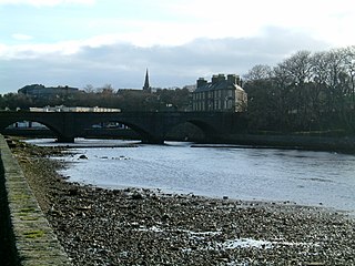
Wick is a town and royal burgh in Caithness, in the far north of Scotland. The town straddles the River Wick and extends along both sides of Wick Bay. "Wick Locality" had a population of 6,954 at the time of the 2011 census, a decrease of 3.8% from 2001.

Lairg is a village and parish in Sutherland, Scotland. It has a population of 891 and is at the south-eastern end of Loch Shin.

Wick River, known also as River Wick, is a river in Caithness in Highland, Scotland. It has its source at the confluence of Scouthal Burn and Strath Burn near Achingale Mill at the northern end of Bardarclay Moss in the Flow Country. The river estuary, is in the North Sea bay of Wick and is straddled by the town of Wick. The source is at a height of about 25 metres, about 11 kilometres west and 2 kilometres north of the estuary.
Loch Burn is a stream that flows out of the eastern end of Loch Watten in Caithness, in the Highland area of Scotland, at a height of around 17 metres (55 ft) and about one kilometre north/northeast of the village of Watten. Less than a kilometre east of its source at Loch Watten the burn flows into Wick River.

The River Thurso has Loch Rumsdale in Caithness as its source, about 26 kilometres (16 mi) south and 14 kilometres (8.7 mi) west of the burgh of Thurso, Caithness, and about 2 kilometres (1.2 mi) south of the railway line linking the burghs of Thurso and Wick with Inverness. At its source and until it reaches Loch More the river is known also as Strathmore Water. Caithness is in the Highland area of Scotland.

The A99 road is entirely within the former county of Caithness in the Highland of Scotland. It runs generally north/northeast from the A9 at Latheron to Wick and to the A836 at John o' Groats. It was part of the A9 until the A9 classification was transferred to what had been the A895-A882 link between Latheron and Thurso. Between Latheron and Wick it follows, mostly, the route of one of Telford's roads.

The A882 road is entirely within Caithness in the Highland area of Scotland. It has a length of about 23 kilometres (14 mi) and runs generally west/northwest from the A99 in the county town of Wick to the A9 in the Georgemas area.

Comrie is a village and parish in the southern Highlands of Scotland, towards the western end of the Strathearn district of Perth and Kinross, 7 mi (11 km) west of Crieff.

Thurso railway station is a railway station located in Thurso, in the Highland council area in the far north of Scotland. It serves the town and its surrounding areas, along with ferry services linking the mainland with Stromness on the Orkney Islands.

Loch Watten is a loch in the River Wick drainage basin in Caithness, Scotland. The name is a tautology, consisting of the word "loch" and vatn, a Norse word meaning the very same, found in such names as "Þingvallavatn" and Myvatn in Iceland, and "Røssvatnet" and "Møsvatn" in Norway.
The Sutherland and Caithness Railway was a Scottish railway company that built a line from Helmsdale, the terminus of the Duke of Sutherland's Railway to Wick and Thurso in Caithness, giving the northern towns access to Inverness. It was driven through by the efforts of the 3rd Duke of Sutherland and the engineer Joseph Mitchell in the face of apathy from interests in Wick.

Gillock is a small village in Caithness, the north part of the Highland council area of Scotland. It is 262 miles north of Edinburgh, situated between the towns of Wick and Thurso. The village is located at grid reference ND210595, on the B874 road.
Mybster is a small village, in Caithness, Scottish Highlands, and is in the Scottish council area of Highland.
Glen Falloch Halt railway station was a remote rural railway station in Glen Falloch, Stirlingshire, Scotland. Opened in 1946 by the LNER, it was located in Glen Falloch on the Ardlui side of the viaduct, but reported out of use by around 1948.
Inveruglas was a remote temporary private railway station near the hamlet of Inveruglas, Argyll and Bute, Scotland. Opened in 1945 by the LNER, it was built in connection with the construction of the Sloy Hydro-Electric facility and was located on the Ardlui side of the Inveruglas Viaduct and recorded to be out of use by around 1948.
Faslane Platform railway station or Faslane Junction Platform railway station was a temporary private railway station located near the Stuckendoff PoW camp, Shandon, Argyll and Bute, Scotland. Opened in 1945 by the LNER in connection with the construction of the Loch Sloy Hydro-Electric facility and was located on the Shandon side of the Chapel Burn and recorded to be out of use by around 1949 in the British Railways era.

