
The Yorkshire Wolds are hills in the counties of the East Riding of Yorkshire and North Yorkshire in Northern England. They are the northernmost chalk hills in the UK and within lies the northernmost chalk stream in Europe, the Gypsey Race.

Wharram Percy is a deserted medieval village and former civil parish near Wharram-le-Street, now in the parish of Wharram, on the western edge of the chalk Wolds of North Yorkshire, England. It is about 1 mile (1.6 km) south of Wharram-le-Street and is signposted from the Beverley to Malton road (B1248). Wharram Percy was part of the East Riding of Yorkshire until the 1974 boundary changes. In 1931 the parish had a population of 40.

Wold Newton is a small Yorkshire Wolds village and civil parish in the East Riding of Yorkshire, England. It is situated approximately 9 miles (14 km) south of Scarborough and 9 miles (14 km) north-west of Bridlington. Wold Newton is located within the Great Wold Valley and the course of the Gypsey Race, a winterbourne chalk stream, passes through the south of the village. The village of Fordon is also part of the civil parish of Wold Newton. According to the 2011 UK census, Wold Newton parish had a population of 337, an increase on the 2001 UK census figure of 291.

Wold Newton is a village and civil parish in North East Lincolnshire, England. It is situated just over 1 mile (1.6 km) west from the A18 road, 7 miles (11 km) north-west from Louth, and 9.5 miles (15 km) north-east from Market Rasen.

Kilham is a village and civil parish in the East Riding of Yorkshire, England. It is situated about 5 miles (8 km) north-east of Driffield town centre. According to the 2011 UK census, Kilham parish had a population of 1,088, an increase on the 2001 UK census figure of 1,010.

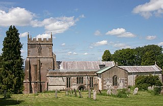
Garton on the Wolds is a village and a civil parish on the Yorkshire Wolds in the East Riding of Yorkshire, England. It is situated approximately 3 miles (5 km) north-west of Driffield town centre and lies on the A166 road.
Ashbury is a village and large civil parish at the upper end (west) of the Vale of White Horse. It was part of Berkshire until the 1974 boundary changes transferred it to Oxfordshire. The village is centred 7 miles (11 km) east of Swindon in neighbouring Wiltshire. The parish includes the hamlets of Idstone and Kingstone Winslow. The 2011 Census recorded the parish's population as 506.

Brantingham is a village and civil parish in the East Riding of Yorkshire, England, about 2 miles (3 km) north of Brough, 12 miles (19 km) west of Hull and north of the A63 road. The 2011 UK Census gave the parish had a population of 370, marking a decrease from the 2001 UK census figure of 410. The 2019 estimate was 319.

Swanland is a village and civil parish in the East Riding of Yorkshire in England. The village is about seven miles (11 km) to the west of Kingston upon Hull city centre and two miles (3.2 km) north of the Humber Estuary in the foothills of the Yorkshire Wolds on the B1231 road.
Cottam is a hamlet and civil parish in the East Riding of Yorkshire, England. The hamlet is west of the B1249 Skipsea to Staxton road, and in the Yorkshire Wolds. It is 16 miles (30 km) north from the county town of Beverley, and approximately 4 miles (6 km) east from the village of Sledmere.

Welton is a village and civil parish in the East Riding of Yorkshire, England. The parish extends to the bank of the Humber Estuary at its southern extreme, and into the Yorkshire Wolds in the northern part. The A63 road and Hull to Selby railway line both bisect the parish east–west, south of Melton and Welton.

Elloughton is a village in the East Riding of Yorkshire, England. It is situated approximately 12 miles (19 km) to the west of Hull to the south of the A63 road. It lies on the southern end of the Yorkshire Wolds. It is conjoined with Brough that lies to the south-east, with which it forms the civil parish of Elloughton-cum-Brough.
Octon is a hamlet and shrunken medieval village in the East Riding of Yorkshire, England.

Cowlam is a hamlet in the civil parish of Cottam, in the East Riding of Yorkshire, England, and in the Yorkshire Wolds. The hamlet is on the B1253 Bridlington to North Grimston road, 17 miles (30 km) north from the county town of Beverley, 2 miles (3 km) east from the village of Sledmere, and 2.5 miles (4 km) north-west from the parish hamlet of Cottam. The hamlet contains eight houses and two farms.

Benningholme is a hamlet in the East Riding of Yorkshire, England, in an area known as Holderness. It is situated approximately 6 miles (10 km) north of Hull city centre and 1 mile (1.6 km) south-west of the village of Skirlaugh. It forms part of the civil parish of Swine.
Lewknor is a village and civil parish about 5 miles (8 km) south of Thame in Oxfordshire. The civil parish includes the villages of Postcombe and South Weston. The 2011 Census recorded the parish's population as 663.

Gayton le Wold is a village and civil parish in the East Lindsey district of Lincolnshire, England. It lies 6 miles (10 km) west from Louth, 3 miles (5 km) north from Donington on Bain, and to the south of the A157. The parish includes Biscathorpe 1 mile (1.6 km) to the south-west.

Welton le Wold is a village and civil parish in the East Lindsey district of Lincolnshire, England. It is situated approximately 4 miles (6 km) west of the town of Louth.
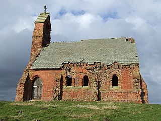
Argam, or Argham, was a village and civil parish, now in the parish of Grindale, in the East Riding of Yorkshire, England. The site is listed in many historical documents, but was deserted by the early 19th century. The village was depopulated, becoming one of the known deserted Medieval villages in Yorkshire.


