Wellsville, Colorado

Last updated

Wellsville, Colorado [1]
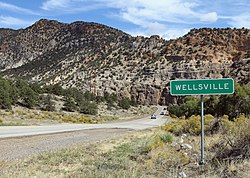
Wellsville, Colorado.JPG
Wellsville and U.S. Highway 50
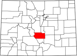
USA Colorado location map.svg
Red pog.svg
Wellsville
Location within Colorado
Coordinates: 38°29′12″N105°54′36″W / 38.48667°N 105.91000°W / 38.48667; -105.91000
Country United States
State Colorado
County Fremont County
Elevation
[1]
6,893 ft (2,101 m)

Wellsville, Colorado is a small unincorporated community in western Fremont County, Colorado, United States. The town straddles the banks of the Arkansas River and follows the U.S. Route 50 before the road starts winding through tight curves into Chaffee County. Wellsville is the site of US Soil's processing facility, where it mines a natural fertilizer from an ancient lake bed. [2]

Contents

See also

Flag of Colorado.svg Coloradoportal

Related Research Articles

<span class="mw-page-title-main">Montgomery County, Missouri</span> County in Missouri, United States

Montgomery County is a county in the east central part of the U.S. state of Missouri. As of the 2020 census, the population was 11,322. Its county seat is Montgomery City. The county was named in honor of Richard Montgomery, an American Revolutionary War general killed in 1775 while attempting to capture Quebec City, Canada.

<span class="mw-page-title-main">Fremont County, Colorado</span> County in Colorado, United States

Fremont County is a county located in the U.S. state of Colorado. As of the 2020 census, the population was 48,939. The county seat is Cañon City. The county is named for 19th-century explorer and presidential candidate John C. Frémont.

<span class="mw-page-title-main">Cañon City, Colorado</span> Home rule municipality in Colorado, United States

Cañon City is a home rule municipality that is the county seat and the most populous municipality of Fremont County, Colorado, United States. The city population was 17,141 at the 2020 United States Census. Cañon City is the principal city of the Cañon City, CO Micropolitan Statistical Area and is a part of the Front Range Urban Corridor. Cañon City straddles the easterly flowing Arkansas River and is a popular tourist destination for sightseeing, whitewater rafting, and rock climbing. The city is known for its many public parks, fossil discoveries, Skyline Drive, The Royal Gorge railroad, the Royal Gorge, and extensive natural hiking paths. In 1994, the United States Board on Geographic Names approved adding the tilde to the official name of Cañon City, a change from Canon City as the official name in its decisions of 1906 and 1975. It is one of the few U.S. cities to have the Spanish Ñ in its name, others being La Cañada Flintridge, California; Española, New Mexico; Peñasco, New Mexico; and Peñitas, Texas.

<span class="mw-page-title-main">Florence, Colorado</span> City in Colorado, United States

The City of Florence is a statutory city located in Fremont County, Colorado, United States. The city population was 3,822 at the 2020 United States Census. Florence is a part of the Cañon City, CO Micropolitan Statistical Area and the Front Range Urban Corridor.

<span class="mw-page-title-main">Lincoln Park, Colorado</span> Census-designated place in Fremont County, Colorado, United States

Lincoln Park is a census-designated place (CDP) located in and governed by Fremont County, Colorado, United States. The CDP is a part of the Cañon City, CO Micropolitan Statistical Area. The population of the Lincoln Park CDP was 3,934 at the United States Census 2020. The Cañon City post office serves the area.

<span class="mw-page-title-main">Penrose, Colorado</span> Unincorporated community in Fremont County, Colorado, United States

Penrose is a census-designated place (CDP) and post office located in and governed by Fremont County, Colorado, United States. The CDP is a part of the Cañon City, CO Micropolitan Statistical Area. The Penrose post office has the ZIP Code 81240. At the United States Census 2020, the population of the Penrose CDP was 3,685.

<span class="mw-page-title-main">Rockvale, Colorado</span> Town in Fremont County, Colorado, United States

Rockvale is a statutory town in Fremont County, Colorado, United States. The population was 511 at the 2020 census.

<span class="mw-page-title-main">Williamsburg, Colorado</span> Town in Fremont County, Colorado, United States

Williamsburg is a statutory town located in Fremont County, Colorado, United States. The town population was 731 at the 2020 census. The Florence post office serves Williamsburg.

<span class="mw-page-title-main">Wellsville, Ohio</span> Village in Ohio, United States

Wellsville is a village in southern Columbiana County, Ohio, United States, along the Ohio River. The population was 3,113 at the 2020 census. It is approximately 15 miles (24 km) north of Steubenville and 35 miles (56 km) south of Youngstown.

<span class="mw-page-title-main">Wellsville Mountains</span> Mountain range in Box Elder and Cache counties in Utah, United States

The Wellsville Mountains is a mountain range in Box Elder and Cache counties in Utah, United States, that is part of the Wasatch Range.

<span class="mw-page-title-main">Colorado's 5th congressional district</span> U.S. House district for Colorado

Colorado's 5th congressional district is a congressional district in the U.S. state of Colorado. The district lies in the center of the state and comprises Colorado Springs and its suburbs including Cimarron Hills and Fort Carson.

<span class="mw-page-title-main">Coaldale, Colorado</span> Census-designated place in Fremont County, Colorado, United States

Coaldale is a census-designated place (CDP) and post office located in and governed by Fremont County, Colorado, United States. The CDP is a part of the Cañon City, CO Micropolitan Statistical Area. The Coaldale post office has the ZIP Code 81222. At the United States Census 2020, the population of the Coaldale CDP was 343.

<span class="mw-page-title-main">Cotopaxi, Colorado</span> Census Designated Place in Colorado, United States

Cotopaxi is an unincorporated town, a post office, and a census-designated place (CDP) located in and governed by Fremont County, Colorado, United States. The CDP is a part of the Cañon City, CO Micropolitan Statistical Area. The Cotopaxi post office has the ZIP Code 81223. At the United States Census 2020, the population of the Cotopaxi CDP was 44.

<span class="mw-page-title-main">South Central Colorado Urban Area</span> Metropolitan area of Colorado

The South Central Colorado Urban Area comprises the Colorado Springs Metropolitan Statistical Area, the Pueblo Metropolitan Statistical Area, and the Cañon City Micropolitan Statistical Area in the central and south central region of the State of Colorado. With the exception of northern Teller County and small portions of northern El Paso County, the entire South Central Colorado Urban Area is drained by the Arkansas River and its tributaries. The South Central Colorado Urban Area is the southernmost of the three primary subregions of the Front Range Urban Corridor.

<span class="mw-page-title-main">Howard, Colorado</span> Census-designated place in Fremont County, Colorado, United States

Howard is a census-designated place (CDP) and post office in and governed by Fremont County, Colorado, United States. The CDP is a part of the Cañon City, CO Micropolitan Statistical Area. The Howard post office has the ZIP Code 81233. At the United States Census 2020, the population of the Howard CDP was 852.

<span class="mw-page-title-main">K-33 (Kansas highway)</span> State highway in Kansas

K-33 is an approximately 10.4-mile-long (16.7 km) north–south state highway in the U.S. state of Kansas. K-33's southern terminus is at K-68 in rural Franklin County east of Ottawa and the northern terminus is at U.S. Route 56 (US-56) in Douglas County, east of Baldwin City and southwest of Kansas City. K-33 provides an important link between US-56 and K-68 to Interstate 35 (I-35) and US-50 in Wellsville. K-33 is a two-lane rural highway for most of its length, except for the section within Wellsville.

The Federal Correctional Complex, Florence is a United States federal prison complex for male inmates in Colorado. It is operated by the Federal Bureau of Prisons, a division of the United States Department of Justice, and consists of four facilities:

<span class="mw-page-title-main">Bushnell Peak</span> Mountain in the American state of Colorado

Bushnell Peak is a prominent mountain summit in the Sangre de Cristo Range of the Rocky Mountains of North America. The 13,110-foot (3,996 m) thirteener is located 7.2 miles (11.6 km) north-northeast of the community of Villa Grove, Colorado, United States, on the drainage divide separating Rio Grande National Forest and Saguache County from San Isabel National Forest and Fremont County. Bushnell Peak is the highest point in Fremont County.

<span class="mw-page-title-main">Texas Creek, Colorado</span> Unincorporated community in Colorado, U.S.

Texas Creek, Colorado is an unincorporated community at the junction of U.S. Highway 50 and State Highway 69 in Fremont County, Colorado, United States.

Bill Williams Peak, elevation 13,389 feet (4,081 m), is an mountain located in Pitkin County, Colorado, United States. The summit of the mountain is the high point of the Williams Mountains, a subrange of the Sawatch Range. The summit is located 12.2 miles (19.6 km) east of Aspen, Colorado, in the Hunter–Fryingpan Wilderness of White River National Forest. Bill Williams Peak is the 42nd highest major summit of Colorado and the 45th highest major summit of the Rocky Mountains of the United States and Canada.

References

  1. 1 2 "Wellsville". Geographic Names Information System . United States Geological Survey, United States Department of the Interior.
  2. Sering, Ron (June 1, 2010). "US Soil: Family finds Fertile Ground for Mining in Wellsville". Colorado Central Magazine. Retrieved August 18, 2018.