Brookside, Colorado | |
---|---|
Entering from the east on Highway 115. | |
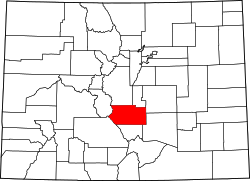
![]() Location of the Town of Brookside in Fremont County, Colorado. | |
Coordinates: 38°24′55″N105°11′31″W / 38.4153°N 105.1919°W [2] | |
Country | United States |
State | Colorado |
County | Fremont County [3] |
Government | |
• Type | Statutory Town [1] |
Area | |
• Total | 0.474 sq mi (1.227 km2) |
• Land | 0.474 sq mi (1.227 km2) |
• Water | 0.000 sq mi (0.000 km2) |
Elevation | 5,348 ft (1,630 m) |
Population | |
• Total | 236 |
• Density | 498/sq mi (192/km2) |
• Metro | 48,939 |
• CSA | 217,101 |
• Front Range | 5,055,344 |
Time zone | UTC−07:00 (MST) |
• Summer (DST) | UTC−06:00 (MDT) |
ZIP code [5] | Cañon City CO 81212 |
Area code | 719 |
GNIS pop ID | 192018 |
GNIS town ID | 2411733 |
FIPS code | 08-09115 |
Website | townofbrookside |
Brookside is a Statutory Town located in Fremont County, Colorado, United States. [1] The town population was 236 at the 2020 United States Census. [4]
The Brookside, Colorado, post office operated from May 21, 1888, until March 15, 1909. [6] The Town of Brookside was incorporated in 1913. [1] Brookside postal addresses are now served by the Cañon City, Colorado post office (ZIP code 81212).
Brookside is located at coordinates 38°24′55″N105°11′31″W / 38.4153°N 105.1919°W at an elevation of 5,348 feet (1,630 m). [2]
At the 2020 United States Census, the town had a total area of 303 acres (1.227 km2), all of it land. [4]
Census | Pop. | Note | %± |
---|---|---|---|
1920 | 202 | — | |
1930 | 198 | −2.0% | |
1940 | 196 | −1.0% | |
1950 | 175 | −10.7% | |
1960 | 163 | −6.9% | |
1970 | 173 | 6.1% | |
1980 | 178 | 2.9% | |
1990 | 183 | 2.8% | |
2000 | 219 | 19.7% | |
2010 | 233 | 6.4% | |
2020 | 236 | 1.3% | |
U.S. Decennial Census |
Brookside is a part of the Cañon City, CO Micropolitan Statistical Area.
As of the census [7] of 2000, there were 219 people, 85 households, and 62 families residing in the town. The population density was 507.5 inhabitants per square mile (195.9/km2). There were 88 housing units at an average density of 203.9 per square mile (78.7/km2). The racial makeup of the town was 96.35% White, 0.46% Native American, 0.46% from other races, and 2.74% from two or more races. Hispanic or Latino of any race were 10.96% of the population.
There were 85 households, out of which 28.2% had children under the age of 18 living with them, 63.5% were married couples living together, 5.9% had a female householder with no husband present, and 25.9% were non-families. 23.5% of all households were made up of individuals, and 11.8% had someone living alone who was 65 years of age or older. The average household size was 2.58 and the average family size was 3.02.
In the town, the population was spread out, with 23.3% under the age of 18, 5.5% from 18 to 24, 26.9% from 25 to 44, 26.0% from 45 to 64, and 18.3% who were 65 years of age or older. The median age was 42 years. For every 100 females, there were 97.3 males. For every 100 females age 18 and over, there were 102.4 males.
The median income for a household in the town was $34,688, and the median income for a family was $40,833. Males had a median income of $33,333 versus $26,875 for females. The per capita income for the town was $14,841. About 13.8% of families and 13.7% of the population were below the poverty line, including 29.6% of those under the age of eighteen and none of those 65 or over.
Fremont County is a county located in the U.S. state of Colorado. As of the 2020 census, the population was 48,939. The county seat is Cañon City. The county is named for 19th-century explorer and presidential candidate John C. Frémont.
The Town of Deer Trail is a Statutory Town located in eastern Arapahoe County, Colorado, United States. The town population was 1,068 at the 2020 United States Census, a +95.60% increase since the 2010 United States Census. Deer Trail is a part of the Denver–Aurora–Lakewood, CO Metropolitan Statistical Area and the Front Range Urban Corridor. The town is situated along Interstate 70, approximately 55 miles (89 km) east of Denver.
Blanca is a Statutory Town located in Costilla County, Colorado, United States. The town population was 322 at the 2020 census. Blanca is located in the enormous San Luis Valley.
Avon is a Home Rule Town located in Eagle County, Colorado, United States. The town population was 6,072 at the 2020 United States Census. The town is a part of the Edwards, CO Micropolitan Statistical Area. Avon is the gateway to the Beaver Creek Resort which lies about two miles (3 km) south of the town. It was the previous site of Vail Resorts before the company moved its physical headquarters to Broomfield, Colorado, in 2006. The town is the home of Liberty Skis, an independent ski manufacturing company.
The Town of Gypsum is the home rule municipality that is the most populous municipality in Eagle County, Colorado, United States. The town population was 8,040 at the 2020 United States Census, a +24.13% increase since the 2010 United States Census. Gypsum is a part of the Edwards, CO Micropolitan Statistical Area. Gypsum is the home of an American Gypsum drywall plant and mine.
The City of Florence is a statutory city located in Fremont County, Colorado, United States. The city population was 3,822 at the 2020 United States Census. Florence is a part of the Cañon City, CO Micropolitan Statistical Area and the Front Range Urban Corridor.
Bayfield is a Statutory Town located in La Plata County, Colorado, United States. The town population was 2,838 at the 2020 United States Census, a +21.65% increase since the 2010 United States Census. Bayfield is part of the Durango, CO Micropolitan Statistical Area.
Branson is a Statutory Town located in Las Animas County, Colorado, United States. The town population was 57 at the 2020 United States Census. Branson is the southernmost town in the State of Colorado, located just 0.3 miles (0.48 km) from the New Mexico border.
Arriba is a Statutory Town located in Lincoln County, Colorado, United States. The town population was 202 at the 2020 United States census.
The Town of Crook is a Statutory Town in Logan County, Colorado, United States. The town population was 133 at the 2020 United States Census. Crook is a part of the Sterling, CO Micropolitan Statistical Area.
The Town of Fleming is a statutory town in Logan County, Colorado, United States. The town population was 428 at the 2020 United States Census. Fleming is a part of the Sterling, CO Micropolitan Statistical Area.
Naturita is a statutory town in Montrose County, Colorado, United States. The population was 485 at the 2020 census, down from 546 in 2010.
Brush is a Statutory City located in Morgan County, Colorado, United States. The city population was 5,339 at the 2020 United States Census. Brush is a part of the Fort Morgan, CO Micropolitan Statistical Area.
Wiggins is a statutory town in Morgan County, Colorado, United States. The population was 1,401 as of the 2020 census, up from 893 at the 2010 census.
Hartman is a statutory town in Prowers County, Colorado, United States. The town population was 56 at the 2020 United States Census. The town is located North of SH-196.
Boone is a Statutory Town located along the Arkansas River in Pueblo County, Colorado, United States. The town population was 305 at the 2020 United States Census.
The Town of Hayden is a home rule municipality located in Routt County, Colorado, United States. The town population was 1,941 at the 2020 United States Census. Hayden is a part of the Steamboat Springs, CO Micropolitan Statistical Area. The town sits along U.S. Highway 40 in the Yampa River Valley between Craig and Steamboat Springs. Hayden is located near the Yampa Valley Regional Airport, by which Hayden is one of the smallest communities in the U.S. to have mainline passenger jet service provided by American Airlines, Delta Air Lines, Southwest Airlines and United Airlines on a scheduled basis.
Blue River is a Statutory Town located along the Blue River in Summit County, Colorado, United States. The town population was 877 at the 2020 United States Census. The town is located in the Blue River Valley along Colorado state highway route 9.
The Town of Gilcrest is a Statutory Town located in Weld County, Colorado, United States. The town population was 1,029 at the 2020 United States Census. Gilcrest is a part of the Greeley, CO Metropolitan Statistical Area and the Front Range Urban Corridor.
The Town of Coal Creek is a Statutory Town located in Fremont County, Colorado, United States. The town population was 364 at the 2020 United States Census. Coal Creek is a part of the Cañon City, CO Micropolitan Statistical Area and the Front Range Urban Corridor.