Williamsburg, Colorado

Last updated

Williamsburg, Colorado
Williamsburg, Colorado.JPG
The town hall on John Street, September 2018
Fremont County Colorado Incorporated and Unincorporated areas Williamsburg Highlighted 0885155.svg
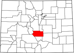
Location of Williamsburg in Fremont County, Colorado.
Coordinates: 38°23′1″N105°9′37″W / 38.38361°N 105.16028°W / 38.38361; -105.16028
Country Flag of the United States (23px).png  United States
State Flag of Colorado.svg Colorado
County [1] Fremont County
Incorporated April 7, 1888 [2]
Government
  Type Statutory Town [1]
Area
[3]
  Total
3.53 sq mi (9.15 km2)
  Land3.53 sq mi (9.15 km2)
  Water0.00 sq mi (0.00 km2)
Elevation
[4]
5,390 ft (1,643 m)
Population
 (2020) [5]
  Total
731
  Density210/sq mi (80/km2)
Time zone UTC-7 (Mountain (MST))
  Summer (DST) UTC-6 (MDT)
ZIP code [6]
81226
Area code 719
FIPS code 08-85155
GNIS feature ID 0203567
Website williamsburgcolorado.com

Williamsburg is a statutory town located in Fremont County, Colorado, United States. The town population was 731 at the 2020 census. [5] The Florence post office (ZIP code 81226) serves Williamsburg. [6]

Contents

History

Geography

Williamsburg is located in southeastern Fremont County at 38°23′1″N105°9′37″W / 38.38361°N 105.16028°W / 38.38361; -105.16028 (38.383623, -105.160337). [7] It is bordered to the east by the city of Florence and to the south by the town of Rockvale. Cañon City, the county seat, is 8 miles (13 km) to the northwest.

According to the United States Census Bureau, Williamsburg has a total area of 3.6 square miles (9.2 km2), all of it land. [8]

Education

It is in the Fremont RE-2 School District. [9]

Demographics

Historical population
CensusPop.Note
1900 337
1910 55665.0%
1920 402−27.7%
1930 155−61.4%
1940 97−37.4%
1950 65−33.0%
1960 57−12.3%
1970 7531.6%
1980 72−4.0%
1990 253251.4%
2000 714182.2%
2010 662−7.3%
2020 73110.4%
U.S. Decennial Census

See also

References

  1. 1 2 "Active Colorado Municipalities". State of Colorado, Department of Local Affairs. Archived from the original on December 12, 2009. Retrieved September 1, 2007.
  2. "Colorado Municipal Incorporations". State of Colorado, Department of Personnel & Administration, Colorado State Archives. December 1, 2004. Archived from the original on August 23, 2003. Retrieved September 2, 2007.
  3. "2019 U.S. Gazetteer Files". United States Census Bureau. Retrieved July 1, 2020.
  4. "US Board on Geographic Names". United States Geological Survey. October 25, 2007. Retrieved January 31, 2008.
  5. 1 2 United States Census Bureau. "Williamsburg town; Colorado" . Retrieved April 24, 2023.
  6. 1 2 "ZIP Code Lookup" (JavaScript/HTML). United States Postal Service. December 14, 2006. Retrieved December 14, 2006.
  7. "US Gazetteer files: 2010, 2000, and 1990". United States Census Bureau. February 12, 2011. Retrieved April 23, 2011.
  8. "Geographic Identifiers: 2010 Census Summary File 1 (G001): Williamsburg town, Colorado". American Factfinder. U.S. Census Bureau. Archived from the original on February 13, 2020. Retrieved April 21, 2016.
  9. Geography Division (December 17, 2020). 2020 CENSUS - SCHOOL DISTRICT REFERENCE MAP: Fremont County, CO (PDF) (Map). U.S. Census Bureau . Retrieved August 4, 2025. - Text list