Rockvale, Colorado

Last updated

Rockvale, Colorado
Rockvale, Colorado.JPG
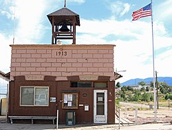
Rockvale's town hall on Railroad St.
Flag of Rockvale, Colorado.png
Seal of Rockvale, Colorado.png
Fremont County Colorado Incorporated and Unincorporated areas Rockvale Highlighted 0864970.svg
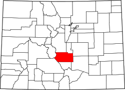
Location of Rockvale in Fremont County, Colorado.
Coordinates: 38°22′8″N105°9′53″W / 38.36889°N 105.16472°W / 38.36889; -105.16472
CountryFlag of the United States (23px).png  United States
State Flag of Colorado.svg Colorado
County [1] Fremont County [2]
Incorporated (town) September 30, 1886 [3]
Government
  Type Statutory Town [1]
Area
[4]
  Total
2.04 sq mi (5.28 km2)
  Land2.04 sq mi (5.28 km2)
  Water0.00 sq mi (0.00 km2)
Elevation
[2]
5,463 ft (1,665 m)
Population
 (2020) [5]
  Total
511
  Density250/sq mi (97/km2)
Time zone UTC-7 (Mountain (MST))
  Summer (DST) UTC-6 (MDT)
ZIP code [6]
81244 (PO Box)
Area code 719
FIPS code 08-64970
GNIS feature ID 0203568
Highways none
Website Official website

Rockvale is a statutory town in Fremont County, Colorado, United States. The population was 511 at the 2020 census. [5]

Contents

History

Geography

Rockvale is located in southeastern Fremont County at 38°22′8″N105°9′53″W / 38.36889°N 105.16472°W / 38.36889; -105.16472 (38.368845, -105.164813). [7] It is bordered to the north by the town of Williamsburg, and the town of Coal Creek is to the east.

According to the United States Census Bureau, the town of Rockvale has a total area of 1.9 square miles (5.0 km2), all of it land. [8]

Demographics

Historical population
CensusPop.Note
1900 870
1910 1,41362.4%
1920 1,249−11.6%
1930 710−43.2%
1940 575−19.0%
1950 380−33.9%
1960 4138.7%
1970 359−13.1%
1980 338−5.8%
1990 321−5.0%
2000 42632.7%
2010 48714.3%
2020 5114.9%


Education

It is in the Fremont RE-2 School District. [9]

See also

References

  1. 1 2 "Active Colorado Municipalities". State of Colorado, Department of Local Affairs. Archived from the original on December 12, 2009. Retrieved September 1, 2007.
  2. 1 2 "US Board on Geographic Names". United States Geological Survey. October 25, 2007. Retrieved January 31, 2008.
  3. "Colorado Municipal Incorporations". State of Colorado, Department of Personnel & Administration, Colorado State Archives. December 1, 2004. Archived from the original on August 23, 2003. Retrieved September 2, 2007.
  4. "2019 U.S. Gazetteer Files". United States Census Bureau. Retrieved July 1, 2020.
  5. 1 2 United States Census Bureau. "Rockvale town; Colorado" . Retrieved April 24, 2023.
  6. "ZIP Code Lookup" (JavaScript/HTML). United States Postal Service . Retrieved December 25, 2007.
  7. "US Gazetteer files: 2010, 2000, and 1990". United States Census Bureau. February 12, 2011. Retrieved April 23, 2011.
  8. "Geographic Identifiers: 2010 Census Summary File 1 (G001): Rockvale town, Colorado". American Factfinder. U.S. Census Bureau. Archived from the original on February 13, 2020. Retrieved April 21, 2016.
  9. Geography Division (December 17, 2020). 2020 CENSUS - SCHOOL DISTRICT REFERENCE MAP: Fremont County, CO (PDF) (Map). U.S. Census Bureau . Retrieved August 4, 2025. - Text list