Wentworth-Nord, Quebec

Last updated
Wentworth-Nord
Wentworth-North-Laurel.JPG
Laurel
Wentworth-Nord Quebec location diagram.png
Location within Les Pays-d'en-Haut RCM
Canada Central Quebec location map.png
Red pog.svg
Wentworth-Nord
Location in central Quebec
Coordinates: 45°51′N74°27′W / 45.85°N 74.45°W / 45.85; -74.45 Coordinates: 45°51′N74°27′W / 45.85°N 74.45°W / 45.85; -74.45 [1]
Country Canada
Province Quebec
Region Laurentides
RCM Les Pays-d'en-Haut
Settled1855
ConstitutedJanuary 1, 1958
Government
[2]
  MayorDanielle Desjardins
   Federal riding Argenteuil—Papineau—Mirabel
   Prov. riding Argenteuil
Area
  Total172.40 km2 (66.56 sq mi)
  Land158.42 km2 (61.17 sq mi)
Population
 (2016) [3]
  Total1,381
  Density8.8/km2 (23/sq mi)
  Pop (2011–16)
Decrease2.svg 4.1%
Time zone UTC−5 (EST)
  Summer (DST) UTC−4 (EDT)
Postal code(s)
Area code(s) 450 and 579
Website wentworth-nord.ca OOjs UI icon edit-ltr-progressive.svg

Wentworth-Nord (French for North Wentworth) is a municipality in the Laurentides region of Quebec, Canada, part of the Les Pays-d'en-Haut Regional County Municipality.

Contents

Its communities include Saint-Michel, Laurel, and Montfort. Its many lakes attract many cottage vacationers each summer.

History

The original Wentworth Township, formed in 1809, included both Wentworth and Wentworth-Nord, [4] so their histories are closely related until 1958 when Wentworth-Nord became a separate municipality. [1]

The community of Laurel formed when the first families arrived from Ireland between 1855 and 1860, calling it New Ireland in memory of their homeland. The Laurel Post Office opened in 1886. In 1856, the mission of Wentworth was established, officially renamed to Saint-Michel in 1884. By 1860, McCluskey or McClosky Court opened, probably named after pioneer James McClosky. [1]

From 1899, several mines were commercially exploited, extracting mica (from 1899 onward), chalk (from 1919 to 1923), marl, and graphite. Other economic activity included logging, agriculture, and the manufacture of potash. [1]

Geography

Wentworth-Nord is composed of three small towns: Montfort, Laurel, and Saint Michel-de-Wentworth. The largest of these is Laurel, which contains the Town Hall and other major municipal and civic installations.

The municipality of Wentworth-Nord is largely wooded and mountainous terrain. It is one of two main head waters for the Rivière à Simon (English: Simon River), and has one main river, the Rivière de L'Ouest (English: West River). Both are tributaries of the Rivière du Nord.

Lakes

A small portion of Lac Louisa is located in Wentworth-Nord, Quebec.

Lac Saint-François-Xavier ( 74°21′32″S45°52′53″E / 74.35889°S 45.88139°E / -74.35889; 45.88139 ) is believed to have been named after François-Xavier Froideveaux. [5] Work undertaken in 2011 restored the lake's natural shore near the Montfort recreational building. [6]

Demographics

Canada census – Wentworth-Nord, Quebec community profile
2016 2011
Population:1,381 (-4.1% from 2011)1,440 (6.4% from 2006)
Land area:156.48 km2 (60.42 sq mi)158.42 km2 (61.17 sq mi)
Population density:8.8/km2 (23/sq mi)9.1/km2 (24/sq mi)
Median age:54.3 (M: 55.0, F: 53.4)55.8 (M: 56.1, F: 55.6)
Total private dwellings:1,9891,958
Median household income:$51,584
References: 2016 [7] 2011 [8] earlier [9]
Historical census populations – Wentworth-Nord, Quebec
YearPop.±%
1986 593    
1991 789+33.1%
1996 1,039+31.7%
2001 1,121+7.9%
2006 1,353+20.7%
2011 1,440+6.4%
2016 1,381−4.1%
Source: Statistics Canada
St-Michel-de-Wentworth St-Michel-de-Wentworth.JPG
St-Michel-de-Wentworth

Mother tongue: [3]

Local government

List of former mayors:

Tourism and activities

Wentworth-Nord is known primarily for outdoor oriented activities. It is one of many municipalities that has a section of the Aerobic Corridor passing through its territory. The majority of the tourist activity is located at either one of three camp grounds, or in Montfort at the Pavilion. The main summer activities are hiking, mountain biking, kayaking, and SUP. In the winter they are cross country skiing, fat bike, and snowshoeing. Wentworth-Nord maintains 25km of trails in the Montfort Sector for recreational use, and the municipality is also home to 9km of the Aerobic Corridor. [10] [11]

Municipal services

Fire Department

The municipality of Wentworth-Nord has a part-time fire department, the Service Security et Incendie Wentworth-Nord (SSIWWN) that was founded in 1972. The SSIWWN has its force trained as both Fire Fighters and Medical First Responders, allowing them to respond to medical emergencies. The municipality Fire Stations, one located in each of the three towns. Each station is equipped with one custom fire truck and one modified Ford pick up truck as a specialty vehicle (medical emergency, SAR, or extrication.) The department averages approximately 200 calls per year. [12]

Special Constables

Since June 2020 the Municipality has hired and created a department of Public Security staffed by Special Constables. [13] They enforce municipal by-laws and ensure public order.

Education

The Commission scolaire de la Rivière-du-Nord operates French-language public schools. [14]

The Sir Wilfrid Laurier School Board operates English-language public schools:

See also

Related Research Articles

Mirabel, Quebec City in Quebec, Canada

Mirabel is an off-island suburb of Montreal, located in southern Quebec.

Lachute City in Quebec, Canada

Lachute is a town in southwest Quebec, Canada, 62 km (39 mi) northwest of Montreal, on the Rivière du Nord, a tributary of the Ottawa River, and west of Mirabel International Airport. It is located on Autoroute 50, at the junctions of Quebec Provincial Highways Route 148, Route 158, and Secondary Highways 327 and 329.

Morin-Heights Municipality in Quebec, Canada

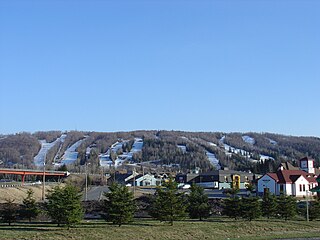
Morin-Heights is a town in the Laurentian Mountains region of Quebec, Canada. It is west of Saint-Sauveur and north of Lachute; municipally, it is within the Regional County Municipality of Les Pays-d'en-Haut.

Saint-Sauveur, Quebec City in Quebec, Canada

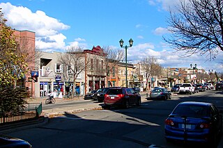
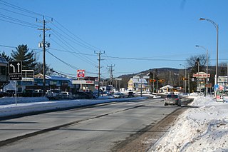
Saint-Sauveur is a town and municipality within the Les Pays-d'en-Haut Regional County Municipality, Quebec, Canada. It is in the administrative region of Laurentides in the Laurentian mountains, located about 60 kilometres north of Montreal.

Brownsburg-Chatham, Quebec City in Quebec, Canada

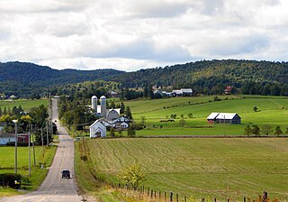
Brownsburg-Chatham is a municipality in the Laurentides region of Quebec, Canada, part of the Argenteuil Regional County Municipality. It is located along the Ottawa River, just west of Lachute, and includes the communities of Brownsburg, Cushing, Dalesville, Greece's Point, Pine Hill, and Saint-Philippe. Economic activities include agriculture, tourism and the manufacture of explosives.

Sainte-Anne-des-Lacs, Quebec Parish municipality in Quebec, Canada

Sainte-Anne-des-Lacs is a municipality in the regional county municipality of Les Pays-d'en-Haut in Quebec, Canada, located in the administrative region of Laurentides. The municipality was founded in 1946 and was assigned the municipal number 77035 by the Quebec government. The Roman Catholic parish of Sainte-Anne-des-Lacs was founded in 1940.

Prévost, Quebec City in Quebec, Canada

Prévost is a town within the La Rivière-du-Nord Regional County Municipality, Quebec, Canada, and the administrative region of Laurentides in the Laurentian Mountains, north of Montreal. It was created in 1973 from the amalgamation of the former villages of Shawbridge and Lesage with old Prévost on the other side of the Rivière du Nord. Shawbridge was named after William Shaw (1805-1894) who settled in the township of Abercromby in 1847 and built the first bridge over the Rivière du Nord.

Piedmont, Quebec Municipality in Quebec, Canada

Piedmont is a small municipality within the Les Pays-d'en-Haut Regional County Municipality, Quebec, Canada, in the Laurentian Mountains of the administrative region of Laurentides. It is located along the North River and Autoroute 15 and Route 117, north of Montreal.

Saint-Hippolyte, Quebec Municipality in Quebec, Canada

Saint-Hippolyte is a municipality within La Rivière-du-Nord Regional County Municipality in the Laurentides region of Quebec, Canada, in the Laurentian mountains about 45 km north of Montreal. The name comes from Saint Hippolytus.

Saint-Adolphe-dHoward, Quebec Municipality in Quebec, Canada

Saint-Adolphe-d'Howard is a municipality in the Laurentian Mountains, in the Province of Quebec, Canada, north-west of Montreal.

Sir Wilfrid Laurier School Board

The Sir Wilfrid Laurier School Board is a school board headquartered in Rosemère, Quebec in Greater Montreal.

Gore, Quebec Township municipality in Quebec, Canada

Gore is a township municipality in the Canadian province of Quebec, located within the Argenteuil Regional County Municipality. Its main community is Lakefield.

Harrington, Quebec Township municipality in Quebec, Canada

Harrington is a township municipality in the Laurentides region of Quebec, Canada, part of the Argenteuil Regional County Municipality. It is located in the Laurentian Mountains, about 40 kilometres (25 mi) north-west of Lachute.

Wentworth, Quebec Township municipality in Quebec, Canada

Wentworth is a township municipality in the Laurentides region of Quebec, Canada, part of the Argenteuil Regional County Municipality, north-west of Lachute.

Saint-Colomban, Quebec City in Quebec, Canada

Saint-Colomban is a city in the regional county municipality of La Rivière-du-Nord in Québec, Canada. It is situated in the Laurentides region of Québec and was named in honour of Saint Columbanus.

Saint-André-dArgenteuil, Quebec Municipality in Quebec, Canada

Saint-André-d'Argenteuil is a municipality in the Laurentides region of Quebec, Canada, part of the Argenteuil Regional County Municipality. It is located along the Ottawa River, just south of Lachute.

Mille-Isles, Quebec Municipality in Quebec, Canada

Mille-Isles is a municipality in the Laurentides region of Quebec, Canada, part of the Argenteuil Regional County Municipality, west of Saint-Jérôme.

Lac-des-Seize-Îles, Quebec Municipality in Quebec, Canada

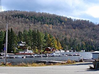
Lac-des-Seize-Îles is a village and municipality in the Laurentides region of Quebec, Canada, part of the Les Pays-d'en-Haut Regional County Municipality. The municipality surrounds and is named after Sixteen Island Lake with the village situated at the northern end of this lake.

Sainte-Sophie, Quebec Municipality in Quebec, Canada

Sainte-Sophie is a municipality in the Laurentides region of Quebec, Canada, part of the La Rivière-du-Nord Regional County Municipality.

Val-Morin, Quebec Municipality in Quebec, Canada

Val-Morin is a municipality in the Laurentides region of Quebec, Canada, part of the Les Laurentides Regional County Municipality.

References

  1. 1 2 3 4 "Wentworth-Nord (Municipalité)" (in French). Commission de toponymie du Québec. Retrieved August 16, 2011.
  2. 1 2 Geographic code 77060 in the official Répertoire des municipalités (in French)
  3. 1 2 3 "(Code 2477060) Census Profile". 2016 census . Statistics Canada. 2017.
  4. "Wentworth (canton)" (in French). Commission de toponymie du Québec. Retrieved August 16, 2011.
  5. "Lac Saint-Francois-Xavier (Fiche descriptive)" (in French). Commission de toponymie du Québec. Retrieved August 16, 2011.
  6. Nicol, Éric (August 4, 2011). "Le Saint-François-Xavier retrouve sa berge naturelle". Le Journal des Pays d'en haut La Vallée (in French). Retrieved August 16, 2011.
  7. "2016 Community Profiles". 2016 Canadian Census . Statistics Canada. February 21, 2017. Retrieved 2020-01-15.
  8. "2011 Community Profiles". 2011 Canadian Census . Statistics Canada. July 5, 2013. Retrieved 2020-01-15.
  9. "2001 Community Profiles". 2001 Canadian Census . Statistics Canada. February 17, 2012.
  10. "Map of Wentworth-Nord Trails in Montfort Sector" (PDF). Retrieved 2020-12-21.
  11. "Plateaux récréatifs, plage et sentiers". Wentworth-Nord (in French). Retrieved 2020-12-21.
  12. "La Gazette de Wentworth-Nord". Wentworth-Nord (in French). Retrieved 2020-12-21.
  13. "Wentworth-Nord Gazette Volume 3, No. 2&3 (April-Sept, 2020)" (PDF). Retrieved 2020-12-21.
  14. "Trouver une école ou un centre." Commission scolaire de la Rivière-du-Nord. Retrieved on September 24, 2017. For attendance boundary information, click "Par bassin d'école"
  15. "LAURENTIAN ELEMENTARY ZONE." Sir Wilfrid Laurier School Board. Retrieved on September 16, 2017.
  16. "MORIN HEIGHTS ELEMENTARY ZONE." Sir Wilfrid Laurier School Board. Retrieved on September 16, 2017.
  17. "LAURENTIAN REGIONAL HS ZONE." Sir Wilfrid Laurier School Board. Retrieved on September 4, 2017.

Commons-logo.svg Media related to Wentworth-Nord at Wikimedia Commons