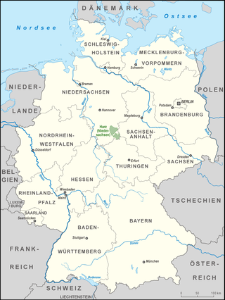
Goslar is a district in Lower Saxony, Germany. It is bounded by the districts of Göttingen, Northeim, Hildesheim and Wolfenbüttel, the city of Salzgitter, and by the states of Saxony-Anhalt and Thuringia (Nordhausen).

Halberstadt was a district (Kreis) in the middle of Saxony-Anhalt, Germany. Neighboring districts were Bördekreis, Quedlinburg, Wernigerode, Goslar, Wolfenbüttel, Helmstedt.

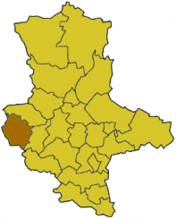
Mansfelder Land was a district (Kreis) in the middle of Saxony-Anhalt, Germany. Neighboring districts were Aschersleben-Staßfurt, Bernburg, Saalkreis, Merseburg-Querfurt, Sangerhausen and Quedlinburg. It was merged on July 1, 2007, with Sangerhausen into the new district Mansfeld-Südharz as part of a reform.

Quedlinburg was a district (Kreis) in the west of Saxony-Anhalt, Germany. Neighboring districts are Wernigerode, Halberstadt, Bördekreis, Aschersleben-Staßfurt, Mansfelder Land, Sangerhausen and the district Nordhausen in Thuringia.
Nordhausen is a Kreis (district) in the north of Thuringia, Germany. Neighboring districts are : Harz and Mansfeld-Südharz in Saxony-Anhalt; Kyffhäuserkreis and Eichsfeld in Thuringia; and Göttingen and Goslar in Lower Saxony.
Harz is a district in Saxony-Anhalt, Germany. Its area is 2,104.9 km2 (812.7 sq mi).
The County of Blankenburg was a state of the Holy Roman Empire. Its capital was Blankenburg, it was located in and near the Harz mountains.

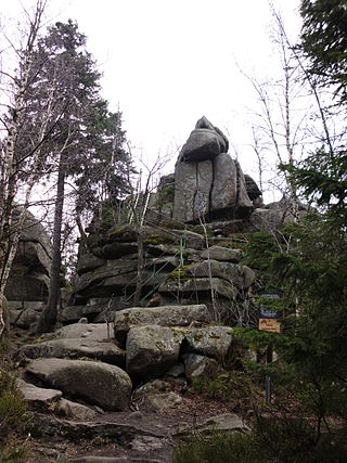
The Muxklippe is a granite rock formation in the Harz National Park in Germany.

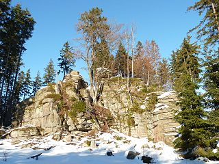
The Trudenstein is a rock formation and popular hiker's destination in the Harz Mountains of central Germany. It is located in the federal state of Saxony-Anhalt.
The Trageburg is a ruined castle immediately next to the Rappbode Pre-Dam in the Harz Mountains of Germany. It is located near Trautenstein in the district of Harz in Saxony-Anhalt.
The Ahrensklint or Ahrentsklint in the Harz Mountains is a granite rock formation, 822.4 m above sea level (NN), on the Erdbeerkopf in Harz district in the German state of Saxony-Anhalt.

The Austberg, also called the Augsberg or Augstberg, is a low hill, 292 m above sea level (NN), in the northern Harz Foreland near the village of Benzingerode in the district of Harz in the German state of Saxony-Anhalt.

The Harz/Saxony-Anhalt Nature Park is situated n the districts of Harz and Mansfeld-Südharz in the German state of Saxony-Anhalt. The nature park which lies in the Harz Mountains was founded in 2003 and has an area of around 1,660 km2. It is looked after by the Harz Regional Association.
The Scherstorklippen is a granite tor in the Harz Mountains of central Germany. It is located near the village of Schierke in the county of Harz in the state of Saxony-Anhalt. It was formed by the process of spheroidal weathering.
The Wilhelmsblick in the Harz Mountains of central Germany is a viewing point near the village of Treseburg in the Bode Gorge in the county of Harz, Saxony-Anhalt. From this single point, four different stretches of the River Bode may be seen as it swings in great loops around the spur on which the viewing point is located.
The Elversstein in the Harz Mountains of Germany is a granite rock formation with a maximum elevation of 499 m above sea level (NN) on the Steinberg near Hasserode in the county of Harz in Saxony-Anhalt.
The Drei-Länder-Stein is a boundary stone at the tripoint of the German federal states of Lower Saxony, Saxony-Anhalt and Thuringia near the Großer Ehrenberg mountain in the Harz.
The Harz Nature Park or just Harz Nature Park lies in the districts of Goslar and Göttingen in South Lower Saxony. The nature park in the Harz Mountains was founded in 1960 and is covers an area of around 790 km². It is run by the Harz Regional Association.

The Stierbergsteich in the Harz Mountains of central Germany is a storage pond near Rothesütte on the boundary of the counties of Harz (Saxony-Anhalt) and Nordhausen (Thuringia).

The South Harz Nature Park is located in the county of Nordhausen in north Thuringia, Germany. The act designating this nature park in the Harz Mountains came into force on 31 December 2010 and thus founded the fifth nature park in Thuringia. It has an area of 267 km². The park is managed by the South Harz Tourist Association in conjunction with the Kyffhäuser Nature Park.
This page is based on this
Wikipedia article Text is available under the
CC BY-SA 4.0 license; additional terms may apply.
Images, videos and audio are available under their respective licenses.