West Asher, Kansas

Last updated
West Asher, Kansas
Map of Mitchell Co, Ks, USA.png
USA Kansas location map.svg
Red pog.svg
West Asher
Usa edcp location map.svg
Red pog.svg
West Asher
Coordinates: 39°28′52″N97°58′36″W / 39.48111°N 97.97667°W / 39.48111; -97.97667
Country United States
State Kansas
County Mitchell
Elevation
1,509 ft (460 m)
Population
  Total0
Time zone UTC-6 (CST)
  Summer (DST) UTC-5 (CDT)
Area code 785
GNIS ID 482378 [1]

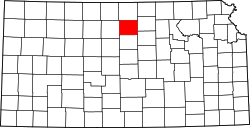
West Asher is a ghost town in Lulu Township, Mitchell County, Kansas, United States. [1]

History

West Asher was issued a post office in 1878. The post office was discontinued in 1888. [2]

Related Research Articles

Asher is a town in Pottawatomie County, Oklahoma. The population was 393 at the 2010 census, a decline of 6.2 percent from the figure of 419 in 2000.

<span class="mw-page-title-main">Wanette, Oklahoma</span> Town in Oklahoma, United States

Wanette is a town in Pottawatomie County, Oklahoma, United States. The population was 279 at the time of the 2020 Census. Wanette is part of the Purcell-Lexington retail trade area and is within the Greater Oklahoma City Metropolitan Area.

<span class="mw-page-title-main">Fort Leavenworth</span> Army installation in Kansas, United States

Fort Leavenworth is a United States Army installation located in Leavenworth County, Kansas, in the city of Leavenworth. Built in 1827, it is the second oldest active United States Army post west of Washington, D.C., and the oldest permanent settlement in Kansas. Fort Leavenworth has been historically known as the "Intellectual Center of the Army."

<span class="mw-page-title-main">John Wilkins Whitfield</span> American politician

John Wilkins Whitfield was a territorial delegate to the United States House of Representatives who represented Kansas Territory from 1854 until 1856. He was an officer in the Confederate Army during the American Civil War, being commissioned as a brigadier general on May 9, 1863.

<span class="mw-page-title-main">Asherville, Kansas</span> Unincorporated community in Mitchell County, Kansas

Asherville is an unincorporated community in Mitchell County, Kansas, United States. As of the 2020 census, the population of the community and nearby areas was 19.

Aetna is an unincorporated community in Barber County, Kansas, United States. It lies at an elevation of 1631 feet.

<span class="mw-page-title-main">Rock Creek, Kansas</span> Unincorporated community in Kansas, United States

Rock Creek is an unincorporated community in Rock Creek Township, Jefferson County, Kansas, United States. It is located along 110th Road near its intersection with K-4.

<span class="mw-page-title-main">Lanham, Kansas and Nebraska</span> Unincorporated community in Kansas and Nebraska, US

Lanham is an unincorporated community in both Washington County, Kansas, and Gage County, Nebraska, United States. The Kansas–Nebraska state line runs down its main street. It is located along State Line Road, about 0.6 miles west of K-148/Nebraska Highway 112. Also, it is 7 miles north of Hanover, Kansas, and 6.5 miles from Odell, Nebraska.

<span class="mw-page-title-main">Grover, Kansas</span> Unincorporated community in Kansas, United States

Grover is an unincorporated community in Douglas County, Kansas, United States. It is located 4 miles west of Lecompton and 6 miles east of Tecumseh.

<span class="mw-page-title-main">Kanwaka, Kansas</span> Unincorporated community in Kansas, United States

Kanwaka is an unincorporated community in Douglas County, Kansas, United States. It is located 4 miles west of Lawrence. The name is a portmanteau of the Kansas and Wakarusa Rivers.

<span class="mw-page-title-main">Paul Randall Harrington</span> American orthopedic surgeon

Paul Randall Harrington was an American orthopaedic surgeon. He is best known as the designer of the Harrington Rod, the first device for the straightening and immobilization of the spine inside the body. It entered common use in the early 1960s and remained the gold standard for scoliosis surgery until the late 1990s. During this period over one million people benefited from Harrington's procedure.

<span class="mw-page-title-main">Fairport, Kansas</span> Unincorporated community in Russell County, Kansas

Fairport is an unincorporated community in Paradise Township, Russell County, Kansas, United States. It is located about 12 miles north of Gorham near the west county line and next the Saline River.

<i>Olympus Has Fallen</i> 2013 American action thriller film directed by Antoine Fuqua

Olympus Has Fallen is a 2013 American political action thriller film directed and co-produced by Antoine Fuqua from a screenplay written by Creighton Rothenberger and Katrin Benedikt, and is the first installment in the Has Fallen film series. The film stars Gerard Butler, Aaron Eckhart, and Morgan Freeman with Angela Bassett, Robert Forster, Cole Hauser, Ashley Judd, Melissa Leo, Dylan McDermott, Radha Mitchell, and Rick Yune in supporting roles. The plot depicts a North Korean-led guerrilla assault on the White House, and focuses on disgraced Secret Service agent Mike Banning's efforts to rescue U.S. President Benjamin Asher.

Traer is an unincorporated community in Decatur County, Kansas, United States.

<span class="mw-page-title-main">Keighley, Kansas</span> Unincorporated community in Butler County, Kansas

Keighley is an unincorporated community in Butler County, Kansas, United States.

West Cedar is a ghost town in Phillips County, Kansas, United States.

<span class="mw-page-title-main">Milo, Kansas</span> Ghost town in Kansas, United States

Milo is a ghost town in Lincoln County, Kansas, United States. It was located along a former railroad about halfway between the communities of Barnard and Ada.

<span class="mw-page-title-main">Lund, Kansas</span> Ghost town in Decatur County, Kansas

Lund is a ghost town in Summit Township of Decatur County, Kansas, United States. It was located 12 miles south and 4 miles west of Oberlin.

References

  1. 1 2 "West Asher, Kansas", Geographic Names Information System , United States Geological Survey, United States Department of the Interior
  2. "Kansas Post Offices, 1828-1961". Kansas Historical Society. Retrieved 2017-12-30.