Related Research Articles
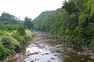
Muncy Creek is a tributary of the West Branch Susquehanna River in Sullivan County and Lycoming County, at Pennsylvania, in the United States. It is approximately 34.5 miles (55.5 km) long. The watershed of the creek has an area of 216 square miles (560 km2). The creek's discharge averages 49 cubic feet per second (1.4 m3/s) at Sonestown, but can be up to a thousand times higher at Muncy. The headwaters of the creek are on the Allegheny Plateau. Rock formations in the watershed include the Chemung Formation and the Catskill Formation.

White Deer Creek is a tributary of the West Branch Susquehanna River in Centre County and Union County, in Pennsylvania, in the United States. It is approximately 28 miles (45 km) long and flows through Miles Township in Centre County and Hartley Township, Lewis Township, West Buffalo Township, and White Deer Township in Union County. The watershed of the creek has an area of 45.1 square miles (117 km2). Parts of the creek are designated as impaired. The creek's discharge near White Deer can be as low as 3 cubic feet per second (0.085 m3/s) or as high as 169 cubic feet per second (4.8 m3/s).

Shamokin Creek is a tributary of the Susquehanna River in Northumberland County, Pennsylvania, in the United States. It is approximately 32.4 miles (52.1 km) long and flows through Mount Carmel, Mount Carmel Township, Coal Township, Shamokin, Ralpho Township, Shamokin Township, Snydertown, Upper Augusta Township, and Sunbury. The watershed of the creek has an area of 137 square miles (350 km2). It experiences significant impacts by abandoned mine drainage and many abandoned mine drainage discharges are in its watershed. Various other impairments also affect parts of the creek's watershed. Shamokin Creek is in the Appalachian Mountains section of the Ridge and Valley physiographic province. Rock formations consisting of sandstone, shale, and anthracite deposits occur in the watershed.
Twomile Run is a tributary of Kettle Creek in Clinton County, Pennsylvania, in the United States. It is 4.5 miles (7.2 km) long. Tributaries of the stream include Huling Branch and Middle Branch Twomile Run. The stream flows through Leidy Township and Noyes Township. The stream's watershed has an area of approximately 9 square miles. Coal is mined in the watershed. Most of the acid mine drainage in Kettle Creek comes from Twomile Run.

Furnace Run is a tributary of Shamokin Creek in Northumberland County, Pennsylvania, in the United States. It is approximately 1.0 mile (1.6 km) long and flows through Coal Township and Shamokin. The watershed of the stream has an area of 1.61 square miles (4.2 km2). It is impaired by sedimentation and siltation from urban runoff and storm sewers, but is not impacted by mine drainage. Reaches of the stream have been entirely enclosed. Furnace Run is named after a furnace that was built in the area in 1825. The stream is designated as a Coldwater Fishery and a Migratory Fishery.

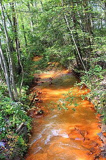
Carbon Run is a tributary of Shamokin Creek in Northumberland County, Pennsylvania, in the United States. It is approximately 5.2 miles (8.4 km) long and flows through Zerbe Township, Coal Township, and Shamokin. The watershed of the stream has an area of 8.78 square miles (22.7 km2). Carbon Run is impaired due to metals from acid mine drainage, which colors the stream orange. Metals such as manganese, iron, aluminum, and others occur within its water. The watershed of the stream is in the Coal Region of Pennsylvania. Much of the area in the vicinity of the stream consists of spoil piles and abandoned mining land.

Coal Run is a tributary of Shamokin Creek in Northumberland County, Pennsylvania, in the United States. It is approximately 4.7 miles (7.6 km) long and flows through Mount Carmel Township, Coal Township, and Shamokin. The watershed of the stream has an area of 6.25 square miles (16.2 km2). The stream is designated as an impaired waterbody due to metals from abandoned mine drainage. It is an ephemeral stream. Virtually all of the watershed is in coal mining regions.
Quaker Run is a tributary of Shamokin Creek in Northumberland County, Pennsylvania, in the United States. It is approximately 3.7 miles (6.0 km) long and flows through Kulpmont, Mount Carmel Township, and Coal Township. The watershed of the stream has an area of 3.62 square miles (9.4 km2). The stream has one unnamed tributary. Quaker Run is designated as an impaired waterbody due to metals from abandoned mine drainage. Raw sewage and stormwater have also been discharged into it at times.
Locust Creek is a tributary of Shamokin Creek in Northumberland County, Pennsylvania, in the United States. It is approximately 4.0 miles (6.4 km) long and flows through East Cameron Township and Mount Carmel Township. The watershed of the creek has an area of 5.75 square miles (14.9 km2). The stream is designated as impaired due to metals from abandoned mine drainage. It also experiences a low pH. The creek flows through a water gap in Locust Mountain. Prominent land uses in its watershed include refuse areas and forested land. The creek's watershed is designated as a Coldwater Fishery and a Migratory Fishery.

North Branch Shamokin Creek is a tributary of Shamokin Creek in Columbia County and Northumberland County, Pennsylvania, United States. It is approximately 4.8 miles (7.7 km) long and flows through Conyngham Township in Columbia County and Mount Carmel Township in Northumberland County. The watershed of the creek has an area of 5.73 square miles (14.8 km2). The entirety of the creek is designated as an impaired waterbody due to metals from abandoned mine drainage. It is acidic, but its pH has been increasing. Underground mine complexes occur within the watershed. The creek has a permeable streambed and experiences flow loss.
South Branch Tunkhannock Creek is a tributary of Tunkhannock Creek in Lackawanna County and Wyoming County, in Pennsylvania, in the United States. It is approximately 22.5 miles (36.2 km) long and flows through Scott Township, Benton Township, North Abington Township, and La Plume Township in Lackawanna County and Clinton Township, Factoryville, and Tunkhannock Township in Wyoming County. The watershed of the creek has an area of 98.3 square miles (255 km2). The creek's named tributaries include Trout Brook, Ackerly Creek, and Kennedy Creek. South Branch Tunkhannock Creek is not designated as an impaired waterbody and has relatively good water quality.
Mouse Creek is a tributary of Schwaben Creek in Northumberland County, Pennsylvania, in the United States. It is approximately 5.6 miles (9.0 km) long and flows through Jordan Township, Washington Township, and Jackson Township. The watershed of the creek has an area of 7.19 square miles (18.6 km2). The creek and its tributaries are not designated as impaired waterbodies. Its watershed is at least partially in the ridge and valley physiographic province. The main land use in the upper reaches of the creek's drainage basin are forested land and agricultural land, but other land uses exist as well. A number of bridges have been constructed across the creek.
Zerbe Run is a tributary of Mahanoy Creek in Northumberland County, Pennsylvania, in the United States. It is approximately 8.3 miles (13.4 km) long and flows through Coal Township, Zerbe Township, and Little Mahanoy Township. The watershed of the stream has an area of 13.1 square miles (34 km2). Part of the stream is impaired by abandoned mine drainage, but its upper reaches are not impacted by mining. Several mine drainage discharges occur within the watershed. The stream is not far from the Western Middle Anthracite Field.

Crab Run is a tributary of Mahanoy Creek in Schuylkill County, Pennsylvania, in the United States. It is approximately 2.5 miles (4.0 km) long and flows through Barry Township. The watershed of the stream has an area of 3.50 square miles (9.1 km2). Despite being listed as impaired by abandoned mine drainage, the stream is not impacted by this; no mining has been done in its watershed. However, some stream reaches in its watershed do experience agricultural impacts. The stream is not far from the Western Middle Anthracite Field. Its watershed is designated as a Coldwater Fishery and a Migratory Fishery. As of 2001, the stream contains macroinvertebrates, but no fish.
Lost Creek is a tributary of Shenandoah Creek in Schuylkill County, Pennsylvania, in the United States. It is approximately 1.3 miles (2.1 km) long and flows through West Mahanoy Township. The watershed of the creek has an area of 1.32 square miles (3.4 km2). The creek is an ephemeral stream in its lower reaches and is impaired by abandoned mine drainage. It is in the Western Middle Anthracite Field. The creek has historically been used as a water supply. It is designated as a Coldwater Fishery.
North Mahanoy Creek is a tributary of Mahanoy Creek in Schuylkill County, Pennsylvania, in the United States. It is approximately 4.4 miles (7.1 km) long and flows through Delano Township, Mahanoy Township, and Mahanoy City. The watershed of the creek has an area of 5.99 square miles (15.5 km2). The creek is designated as an impaired waterbody due to sedimentation/siltation and water/flow variation from abandoned mine drainage. The creek is relatively small, an ephemeral stream in its lower reaches, and is located within the Western Middle Anthracite Field.
Kehly Run is a tributary of Shenandoah Creek in Schuylkill County, Pennsylvania, in the United States. It is less than 2 miles (3.2 km) long and flows through West Mahanoy Township and possibly Shenandoah. The watershed of the stream has an area of 1.63 square miles (4.2 km2). The stream is located within the Western Middle Anthracite Field. A number of dams have been constructed across it. The stream is classified as a Coldwater Fishery and has macroinvertebrates, but no fish.
Hans Yost Creek is a tributary of Deep Creek in Schuylkill County, Pennsylvania, in the United States. It is approximately 3.4 miles (5.5 km) long and flows through Foster Township and Barry Township. The watershed of the creek has an area of 3.52 square miles (9.1 km2). The creek is designated as an impaired waterbody, with the causes being metals and pH and the probable source being abandoned mine drainage. It has no named tributaries, but two abandoned mine discharges flow into it. The creek's watershed was extensively mined in the late 1800s and early 1900s, but the only remaining active mining permits are for remining.
Rausch Creek is a tributary of Pine Creek in Schuylkill County, Pennsylvania, in the United States. It is approximately 1.7 miles (2.7 km) long and flows through Hegins Township. The watershed of the creek has an area of 9.55 square miles (24.7 km2). The creek has two named tributaries: East Branch Rausch Creek and West Branch Rausch Creek. Rausch Creek is designated as an impaired waterbody, with the cause of the impairment being metals and the probable source being abandoned mine drainage.
East Branch Rausch Creek is a tributary of Rausch Creek in Schuylkill County, Pennsylvania, in the United States. It is approximately 2.3 miles (3.7 km) long and flows through Porter Township and Hegins Township. The watershed of the creek has an area of 4.21 square miles (10.9 km2). The creek is impacted by metals, pH, and siltation due to abandoned mine drainage and resource extraction. It drains an area between two mountains: Good Springs Mountain and Big Lick Mountain. There are also two mine pools in the watershed.
References
- 1 2 3 United States Geological Survey, The National Map Viewer , retrieved June 18, 2016
- 1 2 Pennsylvania Gazetteer of Streams (PDF), November 2, 2001, p. 149, retrieved June 18, 2016
- 1 2 United States Environmental Protection Agency, 2006 Waterbody Report for West Branch Rausch Creek , retrieved June 18, 2016
- 1 2 3 4 5 6 7 8 9 10 11 Pennsylvania Department of Environmental Protection (March 2, 2001), RAUSCH CREEK WATERSHED TMDL For Acid Mine Drainage Affected Segments (PDF), pp. 3, 5, 12–14, 37, 45, retrieved June 20, 2016
- 1 2 3 4 Geographic Names Information System, Feature Detail Report for: West Branch Rausch Creek , retrieved June 18, 2016
- ↑ Schuylkill County , retrieved June 18, 2016
- ↑ "MINING ACTIVITY APPLICATIONS", Pennsylvania Bulletin , retrieved June 20, 2016
- ↑ PA Game Commission News Release, August 10, 2015, retrieved June 20, 2016