
Bayview-Montalvin is a former census-designated place (CDP) in Contra Costa County, California, United States. The population was 5,004 at the 2000 census.

La Riviera is a census-designated place (CDP) in Sacramento County, California, United States. It is part of the Sacramento–Arden-Arcade–Roseville Metropolitan Statistical Area. The population was 10,802 at the 2010 census, up from 10,273 at the 2000 census. La Riviera is a primarily residential neighborhood located between the American River on the North side and Highway 50 on the southern border.

Highland Acres is a census-designated place (CDP) in Kent County, Delaware, United States. It is part of the Dover, Delaware Metropolitan Statistical Area. The population was 3,459 at the 2010 census.
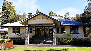
Volcano or Volcano Village is a census-designated place (CDP) in Hawaii County, Hawaii, United States located in the District of Puna with a small portion of the CDP in the District of Kaʻū. The population was 2,575 at the 2010 census, up from 2,231 at the 2000 census.

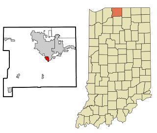
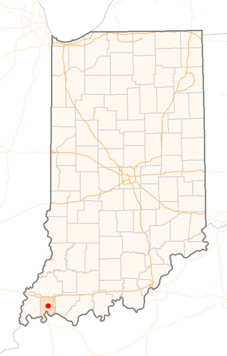
Galena is a census-designated place (CDP) in Floyd County, Indiana, United States. The population was 1,818 at the 2010 census. The CDP includes the town of Galena as well as the nearby town of Floyds Knobs and their immediate surroundings.
Gulivoire Park is a census-designated place (CDP) in Centre Township, St. Joseph County, in the U.S. state of Indiana. The population was 2,974 at the 2000 census. It is part of the South Bend–Mishawaka, IN-MI, Metropolitan Statistical Area.
Highland is a census-designated place (CDP) in Center Township, Vanderburgh County, in the U.S. state of Indiana. The population was 4,489 at the 2010 census.
Claiborne is an unincorporated community and census-designated place (CDP) in Ouachita Parish, Louisiana, United States. The population was 9,830 at the 2000 census. It is part of the Monroe Metropolitan Statistical Area.

Kirtland is a town, made up of part of the former census-designated place (CDP) of the same name in San Juan County, New Mexico, United States. The population of the former CDP was 6,190 at the 2000 census. It is part of the Farmington Metropolitan Statistical Area.

Highland Mills is a hamlet and former census-designated place (CDP) in Orange County, New York, United States. The population was 3,468 at the 2000 census. It is part of the Poughkeepsie–Newburgh–Middletown, NY Metropolitan Statistical Area as well as the larger New York–Newark–Bridgeport, NY-NJ-CT-PA Combined Statistical Area.

Clintondale is a hamlet in Ulster County, New York, United States. The population was 1,938 at the 2020 census.
Forestville is a census-designated place (CDP) in Anderson Township, Hamilton County, Ohio, United States. The population was 10,615 at the 2020 census.

Northgate is a census-designated place (CDP) in Colerain Township, Hamilton County, Ohio, United States. The population was 7,277 at the 2020 census.

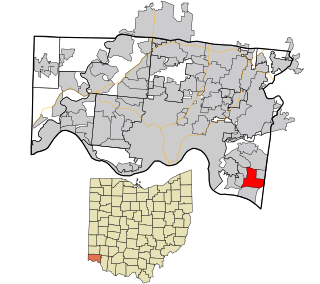
Sherwood is a census-designated place (CDP) in Anderson Township, Hamilton County, Ohio, United States. The population was 3,633 at the 2020 census.

East Highland Park is a census-designated place (CDP) in Henrico County, Virginia, in the United States. The population was 15,131 at the 2020 census.

Clarkston is a city in Asotin County, Washington, United States. It is part of the Lewiston, ID-WA metropolitan area, and is located west of Lewiston, Idaho, across the Snake River.

Clarkston Heights-Vineland is a census-designated place (CDP) in Asotin County, Washington, United States. It is part of the Lewiston, ID–WA Metropolitan Statistical Area. The population was 7,275 at the 2020 census.

Highland was a former unincorporated community and former census-designated place (CDP) in Benton County, Washington, United States. The population was 3,388 at the 2000 census. The area was not listed as a CDP for the 2010 census and the inhabited north end from S Olympia Street to Elliot Lake have since been added to Kennewick.

Loveland Park is a census-designated place (CDP) located in Symmes Township, Hamilton County and Deerfield Township, Warren County, in the southwestern part of the U.S. state of Ohio. The CDP is named after the city of Loveland. The population was 1,737 at the 2020 census.

Highland Lakes is an unincorporated community and census-designated place (CDP) located within Vernon Township, in Sussex County, in the U.S. state of New Jersey. As of the 2010 United States Census, the CDP's population was 4,933. Highland Lakes has its own Post Office with the ZIP Code 07422.

