Related Research Articles

The City of Westminster is a city and borough in Inner London which forms a core part of Central London. It is the site of the United Kingdom's Houses of Parliament and much of the British government. The city and borough's southern boundary is the Thames. It occupies a large area of central Greater London, including most of the West End. To the City of Westminster's east is the City of London and to its west is the Royal Borough of Kensington and Chelsea. To its north is the London Borough of Camden. Historically, Westminster was a part of the ceremonial county of Middlesex. Many London landmarks are within the borough, including Buckingham Palace, the Palace of Westminster, Westminster Abbey, Whitehall, 10 Downing Street, and Trafalgar Square.

The London Borough of Havering in East London, England, forms part of Outer London. It has a population of 259,552 inhabitants; the principal town is Romford, while other communities are Hornchurch, Upminster, Collier Row and Rainham. The borough is mainly suburban, with large areas of protected open space. Romford is a major retail and night time entertainment centre, and to the south the borough extends into the London Riverside redevelopment area of the Thames Gateway. The name Havering is a reference to the Royal Liberty of Havering which occupied the area for several centuries. The local authority is Havering London Borough Council. It is the easternmost London borough.

Lambeth is a London borough in South London, England, which forms part of Inner London. Its name was recorded in 1062 as Lambehitha and in 1255 as Lambeth. The geographical centre of London is at Frazier Street near Lambeth North tube station, though nearby Charing Cross on the other side of the Thames in the City of Westminster is traditionally considered the centre of London.

The Metropolitan Borough of St Marylebone was a metropolitan borough of the County of London from 1900 to 1965. It was based directly on the previously existing civil parish of St Marylebone, which was incorporated into the Metropolitan Board of Works area in 1855, retaining a parish vestry, and then became part of the County of London in 1889.

The Metropolitan Borough of Stoke Newington was a metropolitan borough in the County of London between 1900 and 1965 when it became part of the London Borough of Hackney.

Karen Patricia Buck is a British politician who has been a Member of Parliament (MP) since 1997. Since 2010, she has represented Westminster North in west London. The seat was the successor to Regent's Park and Kensington North, which Buck had held since 1997. A member of the Labour Party, she was Parliamentary Under-Secretary of State for Transport from 2005 to 2006 and has served as Shadow Minister for Social Security since 2020.

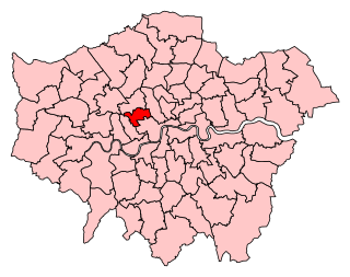
Cities of London and Westminster is a constituency returning a single Member of Parliament (MP) to the House of Commons in the United Kingdom Parliament. It is a borough constituency for the purposes of election expenses and type of returning officer. As with all constituencies, the election is decided using the first past the post system of election. Since its creation at the 1950 general election, the constituency has always elected the candidate nominated by the Conservative Party.
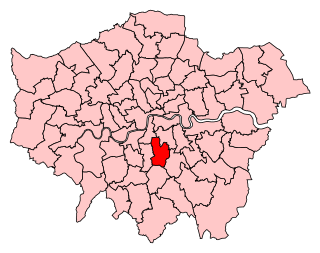
Dulwich and West Norwood is a constituency in South London created in 1997. It has been represented by Helen Hayes of Labour since her election in 2015.
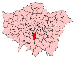
Streatham is a constituency represented in the House of Commons of the UK Parliament since 2019 by Bell Ribeiro-Addy of the Labour Party.
Westminster North is a constituency represented in the House of Commons of the UK Parliament since its 2010 recreation by Karen Buck, a member of the Labour Party. Its previous 1983 to 1997 existence is also covered by this article.

Elections for the Council in the London Borough of Croydon are held every four years to elect 70 councillors. At the last elections, which were held in May 2018, 29 Conservative councillors and 41 Labour councillors were elected, providing a Labour majority of twelve seats.
Elections to Slough Borough Council were held on 4 May 2006. One third of the council was up for election. This was the 121st Slough general local authority election since Slough became a local government unit in 1863.

St Marylebone was a parliamentary constituency centred on the Marylebone district of Central London. It returned one Member of Parliament (MP) to the House of Commons of the Parliament of the United Kingdom.

Holborn and Covent Garden is a ward of the London borough of Camden, in the United Kingdom. As the name suggests, it covers the parts of Holborn and Covent Garden that lie in Camden; the eastern part of Holborn lies in the City of London and the southern part of Covent Garden lies in the City of Westminster. For elections to Parliament, Holborn and Covent Garden is part of Holborn and St Pancras.

Bloomsbury is a ward in the London Borough of Camden, in the United Kingdom. It covers much of the historic area of Bloomsbury, and also some of Covent Garden and Fitzrovia.

Westminster City Council, the local authority of the City of Westminster in London, England, is elected every four years. Since the last boundary changes in 2002, 60 councillors have been elected from 20 wards. New boundary changes will come into effect for the 2022 elections, when the borough will be represented by 54 councillors in 18 three-member wards.

St Andrew's is an electoral ward in the London Borough of Havering. The ward has existed since the creation of the borough on 1 April 1965 and was first used in the 1964 elections. It returns three councillors to Havering London Borough Council.
The 1964 Westminster Council election took place on 7 May 1964 to elect members of Westminster City Council in London, England. The whole council was up for election and the Conservative party gained control of the council.
Elections for the London Borough of Merton were held on 4 May 1978 to elect members of Merton London Borough Council in London, England. This was on the same day as other local elections in England and Scotland.
Elections to Colchester Borough Council took place on 5 May 2016. Colchester Borough Council normally elects one third of its councillors each year, however, due to boundary changes, the whole council is up for election.
References
- ↑ Table PHP01 2011 Census: Usual residents by resident type, and population density, number of households with at least one usual resident and average household size, wards in England and Wales (ONS) accessed 8 February 2013
- ↑ "London Borough Council Elections 4 May 1978" (PDF).
- ↑ "The City of Westminster (Electoral Changes) Order 2000".
- ↑ [ dead link ]
- ↑ [ dead link ]