Perry County is a county located in the U.S. state of Kentucky. As of the 2010 census, the population was 28,712. Its county seat is Hazard. The county was founded in 1820. Both the county and county seat are named for Commodore Oliver Hazard Perry, a naval hero in the War of 1812.

McCreary County is a county located in the U.S. state of Kentucky. As of the 2010 census, the population was 18,306. Its county seat is Whitley City. The county is named for James B. McCreary, a Confederate war hero and two-time Governor of Kentucky. During his second term as Governor, McCreary County was created by the Legislature and was named in his honor.

Elliott County is a county located in the U.S. state of Kentucky. As of the 2010 census, the population was 7,852. Its county seat is Sandy Hook. The county was formed in 1869 from parts of Morgan, Lawrence, and Carter counties, and is named for John Milton Elliott, U.S. Congressman; Confederate Justice of the Kentucky Court of Appeals. In regard to alcohol sales, Elliott County is a dry county, meaning the sale of alcoholic beverages is prohibited everywhere in the county.

Breathitt County is a county located in the eastern Appalachian portion of the U.S. state of Kentucky. As of the 2010 census, the population was 13,878. Its county seat is Jackson, Kentucky. The county was formed in 1839 and was named for John Breathitt, who was Governor of Kentucky from 1832 to 1834. Breathitt County was a prohibition or dry county, until a public vote in July 2016 that allowed alcohol sales.
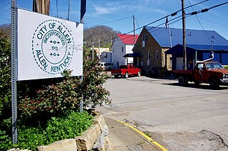
Allen is a home rule-class city in Floyd County, Kentucky, in the United States. The population was 193 at the 2010 census, up from 150 at the 2000 census.

Wayland is a home rule-class city in Floyd County, Kentucky, United States. The population was 426 at the 2010 census, up from 298 at the 2000 census.

Harlan is a home rule-class city in and the county seat of Harlan County, Kentucky, United States. The population was 1,745 at the 2010 census, down from 2,081 at the 2000 census.

The Big Sandy River is a tributary of the Ohio River, approximately 29 miles (47 km) long, in western West Virginia and northeastern Kentucky in the United States. The river forms part of the boundary between the two states along its entire course. Via the Ohio River, it is part of the Mississippi River watershed.

The Cumberland River is a major waterway of the Southern United States. The 688-mile-long (1,107 km) river drains almost 18,000 square miles (47,000 km2) of southern Kentucky and north-central Tennessee. The river flows generally west from a source in the Appalachian Mountains to its confluence with the Ohio River near Paducah, Kentucky, and the mouth of the Tennessee River. Major tributaries include the Obey, Caney Fork, Stones, and Red rivers.

The Tug Fork is a tributary of the Big Sandy River, 159 miles (256 km) long, in southwestern West Virginia, southwestern Virginia, and eastern Kentucky in the United States. Via the Big Sandy and Ohio rivers, it is part of the watershed of the Mississippi River.

The Levisa Fork is a tributary of the Big Sandy River, approximately 164 miles (264 km) long, in southwestern Virginia and eastern Kentucky in the United States.

The Red River, 100 miles (161 km) long, is a major stream of north-central Tennessee, United States and south-central Kentucky and a major tributary of the Cumberland River.
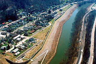
South Williamson is a census-designated place (CDP) in the Appalachian Mountains of northeastern Pike County, Kentucky, United States, on the border with West Virginia. It is separated from Williamson, West Virginia by the Tug Fork River. The community is located near U.S. Route 119 about 23 miles (37 km) east of Pikeville, Kentucky and 28 miles (45 km) southwest of Logan, West Virginia.

Stacy Fork is an unincorporated community in Morgan County, Kentucky, United States. It lies along Route 191 south of the city of West Liberty, the county seat of Morgan County. Its elevation is 823 feet (251 m).
Kentucky Route 101 (KY 101) is a north–south highway traversing three counties in south central Kentucky.
Dwale is an unincorporated community and census-designated place in Floyd County, Kentucky, United States. The 2010 United States Census reported that Dwale's population was 329, of which 312 persons were white and 9 persons were Asian.
Right Fork of Meathouse is an unincorporated community in Pike County, Kentucky, United States. Right Fork of Meathouse is located on Pigpen Branch, the right fork of Meathouse Fork, 12.7 miles (20.4 km) east-northeast of Pikeville.
Ages is an unincorporated coal town and census-designated place (CDP) in Harlan County, Kentucky, United States.
Coxton is an unincorporated coal town and census-designated place (CDP) in Harlan County, Kentucky, United States. Their post office is closed. The community was listed as a CDP in 2014, so no population figures are available from the 2010 census.