
Riddlesden is a suburb of Keighley in the county of West Yorkshire, England and on the Leeds and Liverpool Canal.
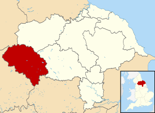
Craven was a non-metropolitan district in the west of North Yorkshire, centred on the market town of Skipton.

Barnoldswick is a market town and civil parish in the Borough of Pendle, in the administrative county of Lancashire, England. It is within the boundaries of the historic West Riding of Yorkshire. Barnoldswick and the surrounding areas of West Craven have been administered since 1974 as part of the modern administrative county of Lancashire. This was when West Riding County Council and Barnoldswick Urban District Council were abolished and the town was transferred to the Borough of Pendle.
Kildwick, or Kildwick-in-Craven, is a village and civil parish of the district of Craven in North Yorkshire, England. It is situated between Skipton and Keighley and had a population of 191 in 2001, rising slightly to 194 at the 2011 census. Kildwick is a landmark as where the major road from Keighley to Skipton crosses the River Aire. The village's amenities include a primary school, church and public house.

Sewerby is a village in the East Riding of Yorkshire, England approximately 1 mile (1.6 km) north-east of Bridlington on the North Sea coast. The village is on Bridlington Bay and is the only south-facing resort in the East Riding of Yorkshire.

Earby is a town and civil parish within the Borough of Pendle, Lancashire, England. Although within the boundaries of the historic West Riding of Yorkshire, Earby has been administered by Lancashire County Council since 1974 and regularly celebrates its Yorkshire roots. It is 5 miles (8 km) north of Colne, 7 miles (11.3 km) south-west of Skipton, and 11 miles (17.7 km) north-east of Burnley. The parish had a population of 4,538 recorded in the 2011 census,

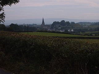
Appletreewick is a village and civil parish in the Craven district of North Yorkshire, England, 6.5 miles (10.5 km) north-east of Skipton, 7 miles (11 km) from Skipton railway station and 16 miles (25.7 km) from Leeds Bradford International Airport.
Burton in Lonsdale is a village and civil parish in the Craven District of North Yorkshire, England, close to the border with Lancashire and Cumbria. It is in Lonsdale. The parish is approximately 1,500 acres (6 km2) in area and has many farms – dairy, beef and sheep. Little is grown, except grass to feed the animals.

Calton is a village and civil parish in the Craven district of North Yorkshire, England, on the River Aire in Airedale. In both the 2001 and 2011 Censuses the population was less than 100, so details were included in the civil parish of Flasby with Winterburn. In 2015, North Yorkshire County Council estimated the population of the village to be 60.

Conistone is a small village in the Craven district of North Yorkshire, England. It lies 3 miles (5 km) north of Grassington, 3 miles (5 km) south of Kettlewell and 12 miles (19 km) north of Skipton beside the River Wharfe, in Upper Wharfedale.

North Stainley is a village in the Harrogate district of North Yorkshire, England 4 miles (6.4 km) north of Ripon. Historically part of the West Riding of Yorkshire, it is the closest settlement to the theme park Lightwater Valley which is 0.62 miles (1 km) to the south.
Long Preston is a village and civil parish in the Craven district of North Yorkshire, England, in the Yorkshire Dales. It lies along the A65 road, and is 12 miles (19 km) from Skipton and 4 miles (6 km) from Settle. The population of Long Preston in 2001 was 680, increasing to 742 at the 2011 Census.

Halton West is a village and civil parish in the Craven district of North Yorkshire, England. North Yorkshire County Council estimated the population in 2015 at 70. It is situated on the River Ribble and is 7 miles (11 km) north of Barnoldswick, 7 miles (11 km) south of Settle and 12 miles (19 km) west of Skipton.

Otterburn is a village and civil parish in the Craven district of North Yorkshire, England. It is at OS Grid Reference SD8857, near Airton, Calton and the A65. The village is 9 miles (14 km) north west of Skipton and 1.9 miles (3 km) east of Hellifield.
Marton-le-Moor is a village and civil parish in the Harrogate district of North Yorkshire, England. It is very near the A1(M) motorway, 4 miles (6.4 km) east of Ripon and 3 miles (4.8 km) west of Boroughbridge. The name of the village derives from a mixture of Latin, Old English and Old Norse; Marr tūn super mōr, which means marsh farm on the moor.

Gisburn is a village and civil parish within the Ribble Valley borough of Lancashire, England. Historically within the West Riding of Yorkshire, it lies 8 miles (13 km) northeast of Clitheroe and 11 miles (18 km) west of Skipton. The civil parish had a population of 506, recorded in the 2001 census, increasing to 521 at the 2011 Census.

East Marton is a village in the Craven District of North Yorkshire, England. It is situated approximately 5 miles (8 km) west of the market town of Skipton and is on the A59 road. The Leeds and Liverpool Canal passes through the village on the descent from Foulridge to Leeds. The canal towpath in the village is part of the Pennine Way and the original pack-horse bridge over the canal was transformed into a double-arched bridge when the new A59 road was built on top of it. The canal was fully opened in 1816 with the section through East Marton being started in 1793. Some of the Navvies who died of smallpox whilst constructing the canal are buried in the churchyard.

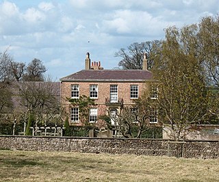
Gledstone Hall is a 20th-century country house in West Marton, near Skipton, North Yorkshire, England. Designed by Edwin Lutyens it stands in a 12-hectare (30-acre) estate. It is a Grade II* listed building. The gardens are separately listed Grade II.

Flasby is a hamlet in the Yorkshire Dales in North Yorkshire, England. It is one of the two settlements, with Winterburn, in the civil parish of Flasby with Winterburn, part of the Craven district. The population of the civil parish was estimated at 80 in 2012, measured at 207 in the 2011 Census.

