
Fluvanna County is a county located in the Piedmont region of the Commonwealth of Virginia. As of the 2010 census, the population was 25,691. Its county seat is Palmyra.

The James River is a river in the U.S. state of Virginia that begins in the Appalachian Mountains and flows 348 miles (560 km) to Chesapeake Bay. The river length extends to 444 miles (715 km) if one includes the Jackson River, the longer of its two source tributaries. It is the longest river in Virginia. Jamestown and Williamsburg, Virginia’s first colonial capitals, and Richmond, Virginia's current capital, lie on the James River.

The history of Richmond, Virginia, as a modern city, dates to the early 17th century, and is crucial to the development of the colony of Virginia, the American Revolutionary War, and the Civil War. After Reconstruction, Richmond's location at the falls of the James River helped it develop a diversified economy and become a land transportation hub.
This article is about the many neighborhoods and districts in the Greater Richmond, Virginia area. Note that this article is an attempt to be inclusive of the broader definitions of the areas which are often considered part of the Greater Richmond Region, based on their urban or suburban character and nature, rather than by strictly political boundaries.

The James River and Kanawha Canal was a partially built canal in Virginia intended to facilitate shipments of passengers and freight by water between the western counties of Virginia and the coast. Ultimately its towpath became the roadbed for a rail line following the same course.
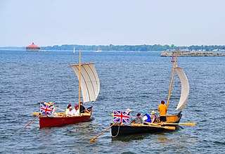
A bateau or batteau is a shallow-draft, flat-bottomed boat which was used extensively across North America, especially in the colonial period and in the fur trade. It was traditionally pointed at both ends but came in a wide variety of sizes. The name derives from the French word, bateau, which is simply the word for boat and the plural, bateaux, follows the French, an unusual construction for an English plural. In the southern United States, the term is still used to refer to flat-bottomed boats, including those elsewhere called jon boats.
The James River Bateau was a shallow draft river craft used during the period from 1775 to 1840 to transport tobacco and other cargo on the James River and its tributaries in the Commonwealth of Virginia. It was flat bottomed and pointed at both ends. The length of the bateau varied greatly, 58 feet being a common length. The bateau was propelled by bateaumen pushing with long sturdy poles. Alternate spellings of bateau include batteau, batoe and the plurals bateaux, batoes, and batteaux. Bateau is the French word for boat. In the colonial days, bateaus were used extensively in rivers throughout the eastern part of the United States, but the coverage of this article is confined to those that plied the James River in the Commonwealth of Virginia.

The Southside of Richmond is an area of the Metropolitan Statistical Area surrounding Richmond, Virginia. It generally includes all portions of the City of Richmond which lie south of the James River, and includes all of the former city of Manchester. Depending on context, the term "Southside of Richmond" can include some northern areas of adjacent Chesterfield County, Virginia in the Richmond-Petersburg region. With minor exceptions near Bon Air, VA, the Chippenham Parkway forms the border between Chesterfield County and the City of Richmond portions of Southside, with some news agencies using the term "South Richmond" to refer to the locations in Southside located in the city proper.

State Route 147 is a primary state highway in the U.S. state of Virginia. The state highway runs 13.13 miles (21.13 km) from U.S. Route 60 in Midlothian east to US 60 in Richmond. In various places, it is known as Huguenot Road, River Road, Cary Street Road and Main Street. SR 147 connects Midlothian with the West End of Richmond via the Huguenot Memorial Bridge across the James River. Within Richmond, the state highway follows Cary Street, a major thoroughfare that connects the city's two major universities, the University of Richmond and Virginia Commonwealth University, with Downtown Richmond.

Westham Bridge crossed the James River between Henrico County and Chesterfield County. The bridge was located between Bosher Dam and Williams Island Dam just west of the 7 miles of rapids and falls which constitute the fall line of the James River at Richmond, Virginia.

Westham Station in Henrico County, Virginia, USA, was originally located at Westham on the Richmond and Allegheny Railroad (R&A), which was laid along the towpath of the James River and Kanawha Canal in the 1880s. The R&A railroad was acquired by the Chesapeake and Ohio Railway (C&O) in the 1890s. Westham Station was built in 1911, near the Westham Bridge, which spans James River. The station was heated by a coal stove and had a telegraph for communication through the 1950s.

The Rivanna River is a 42.1-mile-long (67.8 km) tributary of the James River in central Virginia in the United States. The Rivanna's tributaries originate in the Blue Ridge Mountains; via the James River, it is part of the watershed of Chesapeake Bay.

The Maury River is a 42.8-mile-long (68.9 km) tributary of the James River in west-central Virginia in the United States. It is part of the watershed of Chesapeake Bay.

The Petersburg Railroad ran from Petersburg, Virginia, south to Garysburg, North Carolina, from which it ran to Weldon via trackage rights over the Seaboard and Roanoke Railroad.

Black Heath was a house and coal mine located along the Old Buckingham Road in the present Midlothian area of Chesterfield County, Virginia. The Black Heath coal mining enterprises were operated by the Heth family between 1785 and 1844, when the mine closed following a fatal explosion.
New Canton is an unincorporated town in northeastern Buckingham County, Virginia, United States. It lies along U.S. Route 15 below the James River, northeast of the county seat of Buckingham. Although it is unincorporated, it has a post office, with the ZIP code of 23123.

Howardsville is an unincorporated community in Albemarle County, Virginia.

William Randolph II, also known as William Randolph Jr. or Councillor Randolph, was an American planter and politician. He was the Treasurer of Virginia and the oldest child of William Randolph and Mary Isham.
Pemberton is an unincorporated community in Goochland County, Virginia, United States. Virginia State Route 45 passes by Pemberton, located about 11 miles (18 km) west of Goochland, the county seat. It was named for the family that owned Clover Forest Plantation. Nearby is Howard's Neck Plantation, listed on the National Register of Historic Places.
The Upper Appomattox Canal Navigation system allowed farmers who took their wheat and corn to mills on the Appomattox River, as far way as Farmville, Virginia, to ship the flour all the way to Petersburg from 1745 to 1891. The system included a navigation, modifications on the Appomattox River, a Canal around the falls Petersburg, and a turning basin in Petersburg to turn their narrow long boats around, unload the farm products from upstream and load up with manufactured goods from Petersburg. In Petersburg, workers could put goods on ships bound for the Chesapeake Bay and load goods from far away for Farmville and plantations upstream. Canal boats would return up river with manufactured goods. People who could afford it, rode in boats on the canal as the fastest and most comfortable ride. The river was used for transportation and shipping goods for over 100 years.


