Wheeler, West Virginia | |
---|---|
Unincorporated community | |
View of Wheeler from a scenic overlook | |
Coordinates: 38°41′11″N80°24′09″W / 38.68639°N 80.40250°W Coordinates: 38°41′11″N80°24′09″W / 38.68639°N 80.40250°W | |
Country | United States |
State | West Virginia |
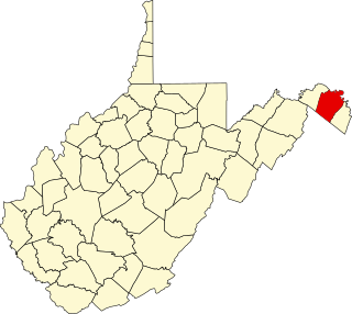
County | Webster |
Elevation | 1,401 ft (427 m) |
Time zone | Eastern (EST) (UTC-5) |
• Summer (DST) | EDT (UTC-4) |
Area code(s) | 304 & 681 |
GNIS feature ID | 1549986 [1] |
Wheeler is an unincorporated community in Webster County, West Virginia, United States. Wheeler is 14.5 miles (23.3 km) north of Webster Springs.
In law, an unincorporated area is a region of land that is not governed by a local municipal corporation; similarly an unincorporated community is a settlement that is not governed by its own local municipal corporation, but rather is administered as part of larger administrative divisions, such as a township, parish, borough, county, city, canton, state, province or country. Occasionally, municipalities dissolve or disincorporate, which may happen if they become fiscally insolvent, and services become the responsibility of a higher administration. Widespread unincorporated communities and areas are a distinguishing feature of the United States and Canada. In most other countries of the world, there are either no unincorporated areas at all, or these are very rare; typically remote, outlying, sparsely populated or uninhabited areas.
Webster County is a county in the U.S. state of West Virginia. As of the 2010 census, the population was 9,154. Its county seat is Webster Springs. The county was founded in 1860 and named for Daniel Webster.
West Virginia is a state located in the Appalachian region in the Southern United States that is also considered to be a part of the Middle Atlantic States. It is bordered by Pennsylvania to the north, Maryland to the east and northeast, Virginia to the southeast, Kentucky to the southwest, and Ohio to the northwest. West Virginia is the 41st largest state by area, and is ranked 38th in population. The capital and largest city is Charleston.
The community was named after Galloway Wheeler. [2] Located near Wheeler is the Lowther Store, listed on the National Register of Historic Places in 1997. [3]
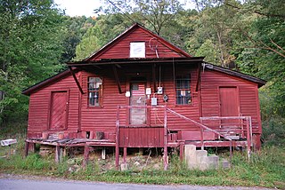
Lowther Store, also known as the John A. Hinkle and Son Store, is a historic general store located near Wheeler, Webster County, West Virginia. It was built about 1900 and expanded about 1910. The store is a one-story rectangular, wood-frame building with a foundation of field stones and posts. Also on the property are a frame coal house, and a storage building located across the roadway. It is the oldest continuous operating business in Webster County.
The National Register of Historic Places (NRHP) is the United States federal government's official list of districts, sites, buildings, structures, and objects deemed worthy of preservation for their historical significance. A property listed in the National Register, or located within a National Register Historic District, may qualify for tax incentives derived from the total value of expenses incurred preserving the property.
Webster is an unincorporated community in Taylor County, West Virginia, United States. It lies four miles south of Grafton. Its elevation is 1,019 feet above sea level.
Switchback is an unincorporated community in McDowell County, West Virginia, United States. Switchback had its own high school in operation from 1923 to 1953.
Files Crossroad is an unincorporated community in Berkeley County, West Virginia. The community is located east of Martinsburg on West Virginia Route 45 at its crossroads with County Route 45/4. The community was originally known as Smoketown, hence the name of its historic Smoketown Cemetery.
Ridgeway is an unincorporated community in Berkeley County, West Virginia. It lies off U.S. Route 11 on Specks Run Road near the Virginia state line.
Tomahawk is an unincorporated community on Back Creek in Berkeley County, West Virginia. The community is named for a nearby series of springs in the shape of a tomahawk. The community includes the historic Tomahawk Presbyterian Church, established c. 1745, and its adjacent community cemetery, which has gravestones dating to the late 18th century.
Elkhorn is an unincorporated community in McDowell County, West Virginia, United States. Elkhorn lies on U.S. Route 52 and takes its name from the creek that flows through the community.
Hacker Valley is an unincorporated community in northern Webster County, West Virginia, USA, along the Left Fork of the Holly River. Its ZIP Code is 26222.
Greenville is an unincorporated community in Monroe County, West Virginia, United States. Greenville is located on West Virginia Route 122 west of Union. The community was formerly called Centreville.
Lockwood is an unincorporated community in western Nicholas County, West Virginia, United States. The town is situated along Otter Creek and West Virginia Route 39.
Tyro is an unincorporated community in Nelson County, Virginia, United States. It was among the communities severely affected by flash flooding from Hurricane Camille in 1969.
London is an unincorporated community in Kanawha County in the U.S. state of West Virginia, located 25 miles from the state capital of Charleston. London Lock and Dam, operated by US Army Corps of Engineers is located here on Kanawha River.
This is a list of the National Register of Historic Places listings in Berkeley County, West Virginia.
The Mountain Parkway Byway and Mountain Parkway Backway are two routes in northern Webster County, West Virginia. The Byway is a state-designated scenic byway which follows West Virginia Route 20 for 9.8 miles (15.8 km), traversing the headwaters of several mountain streams including the Right Fork Little Kanawha River, Jerry Run, and the Left and Laurel Forks of Holly River. The Backway explores backroads in the same area, is 32 miles (51 km) long, and follows stretches of the Right Fork Little Kanawha River and Left Fork Holly River for portions of its route.
Landisburg is an unincorporated community in Fayette County, West Virginia, United States. Landisburg is located along West Virginia Route 41 11 miles (18 km) east of Oak Hill.
Mount Clare is an unincorporated community in Harrison County, West Virginia, USA. Mount Clare is 4.5 miles (7.2 km) south of Clarksburg. Mount Clare has a post office with ZIP code 26408.
St. Clara is an unincorporated community in central Doddridge County, West Virginia, US. Its elevation is 850 feet (254 m).
This is a list of the National Register of Historic Places listings in Webster County, West Virginia.
Harmony Grove is an unincorporated community in Monongalia County, West Virginia.
Coe is an unincorporated community in Nicholas County, West Virginia, United States. Coe is located on County Route 7/6 5.4 miles (8.7 km) east of Craigsville.
![]() | This article about a location in Webster County, West Virginia is a stub. You can help Wikipedia by expanding it. |