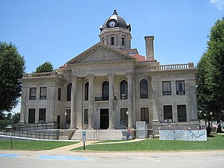
Poinsett County is a county located in the U.S. state of Arkansas. As of the 2010 census, the population was 24,583. The county seat is Harrisburg.

Mississippi County is a county located in the U.S. state of Arkansas. As of the 2010 census, the population was 46,480. There are two county seats, Blytheville and Osceola. The county was formed on November 1, 1833, and named for the Mississippi River which borders the county to the east. Mississippi County is part of the First Congressional District in Arkansas. The Mississippi County Judge is John Alan Nelson.

Craighead County is a county located in the U.S. state of Arkansas. As of the 2010 census, the population was 96,443. The county has two county seats — Jonesboro and Lake City. Craighead County is Arkansas's 58th county, formed on February 19, 1859, and named for state Senator Thomas Craighead. It is one of several dry counties within the state of Arkansas, in which the sale of alcoholic beverages is largely prohibited.
Whitehall is a street in central London.
Whitehall, Arkansas may refer to:

The Jonesboro Metropolitan Statistical Area, as defined by the United States Census Bureau, is an area consisting of two counties – Craighead and Poinsett – in northeast Arkansas, anchored by the city of Jonesboro. As of the 2010 census, the MSA had a population of 121,026. It is also part of the larger Jonesboro-Paragould Combined Statistical Area.

White Hall is a small unincorporated community in El Dorado County, California, United States. It is located on the South Fork of the American River 2.5 miles (4.0 km) east of Riverton, at an elevation of 3383 feet. The ZIP code is 95726. The community is inside area code 530.

White Hall is an unincorporated community in Albemarle County, Virginia.

Plainview is an unincorporated community in Harrison Township, White County, Arkansas, United States. It is located at the intersection of Arkansas Highway 157 and the northern terminus of Arkansas Highway 385.

Payneway is an unincorporated community in Little River Township, Poinsett County, Arkansas, United States. It is located west of Marked Tree near the intersection of Arkansas Highway 463 and Arkansas Highway 14.

White Rock is an unincorporated community in Fayetteville Township, Washington County, Arkansas, United States. It is located about three miles west of Fayetteville on Arkansas Highway 16. Goose Creek is just south of the community.

Joy is an unincorporated community in White County, Arkansas, United States. Joy is located along Arkansas Highway 36, 12.6 miles (20.3 km) west-northwest of Searcy.

Fontaine is an unincorporated community in Shady Grove Township, Greene County, Arkansas, United States. It is located at the western terminus of Arkansas Highway 168 at Arkansas Highway 228.

Mount Olive is an unincorporated community in Poinsett County, Arkansas, United States. Mount Olive is located at the junction of Arkansas Highway 149 and Arkansas Highway 322, 3.5 miles (5.6 km) south of Marked Tree.

Northern Ohio is an unincorporated community in Poinsett County, Arkansas, United States. Northern Ohio is located on Arkansas Highway 75, 2.75 miles (4.43 km) southwest of Marked Tree. A resettlement community was founded at Northern Ohio in 1936 on land bought from the Northern Ohio Cooperage Company.

Weed is an unincorporated community in Poinsett County, Arkansas, United States. Weed is located on the north bank of the St. Francis River and the BNSF Railway near the northwest border of Marked Tree.

Dub is an unincorporated community in Poinsett County, Arkansas, United States. Dub is located along gravel roads, 3.6 miles (5.8 km) east of Marked Tree.

Judd Hill is an unincorporated community in Poinsett County, Arkansas, United States. Judd Hill is located on Arkansas Highway 214, 5 miles (8.0 km) south of Trumann. The Judd Hill Cotton Gin, which is listed on the National Register of Historic Places, is located in Judd Hill. Judd Hill was named for banker and businessman Orange Judd Hill, who founded the community.

Carter (1960–2018) was an unincorporated community in White River Township, Washington County, Arkansas, United States. It is located on Arkansas Highway 74 between Arnett and Sulphur City. At times it was also known as Carter's Store, Carter Store, and Hicks. A post office, for all these names at different times existed from 1875 to 1953. The community has the name of John C. Carter, first postmaster.

Hatchie Coon is an unincorporated community in Poinsett County, Arkansas, United States. It was also known as Coon Station.


