The Pukaskwa River is a river in Thunder Bay District and Algoma District in Northern Ontario, Canada. It is in the Great Lakes Basin and is a tributary of Lake Superior, which it enters at the south end of Pukaskwa National Park. It is a remote, pristine, free-flowing, medium-sized Shield river, with lots of whitewater, best travelled in spring.
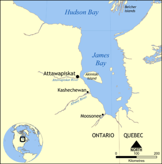
The Attawapiskat River is a river in Kenora District in northwestern Ontario, Canada, that flows east from Attawapiskat Lake to James Bay.
Longcanoe Lake is a narrow lake in Thunder Bay District, Ontario, Canada about 15 kilometres (9 mi) north-east of the community of Rossport and 11 kilometres (7 mi) north of Highway 17. It is oriented in a north–south direction and is about 1,100 metres (3,609 ft) long and 250 metres (820 ft) at its widest, at its north end. The lake is part of the Whitesand River system and flows out at its south end via this river into Hornblende Lake, and eventually via the Hewitson River into Lake Superior. A mine access road travels along the eastern shore of the lake.

The Hewitson River is a short river in Thunder Bay District, northwestern Ontario, Canada. When the Canadian Pacific Railway was being constructed along the north shore of Lake Superior 1882–1885, the river was known as Maggot River.
The Whitesand River is a river in Thunder Bay District, Ontario, Canada, that flows south into the northwest side of Lake Nipigon.
Whitesand Lake is a lake in Thunder Bay District, Ontario, Canada. The primary inflow and outflow is the Whitesand River. The lake is about 3,600 metres (11,811 ft) long and 500 metres (1,640 ft) wide and lies at an elevation of 311 metres (1,020 ft).
North Whitesand Lake is a lake in the Unorganized Part of Thunder Bay District in Northwestern Ontario, Canada. It is the source of the Whitesand River, and is part of the Great Lakes Basin.
North Cleaver Lake is a lake in the Unorganized Part of Thunder Bay District in Northwestern Ontario, Canada. It is about 450 metres (1,480 ft) long and 100 metres (330 ft) wide, has an area of 2.69 hectares, and lies at an elevation of 432 metres (1,417 ft). The lake is in the Lake Superior drainage basin, and is located about 21.5 kilometres (13.4 mi) northwest of the community of Schreiber, and 2 kilometres (1.2 mi) northwest of Cleaver Lake, a lake in the adjacent Hewitson River drainage basin.
Blackett Creek is a river in Thunder Bay District, Ontario, Canada. It starts at Blackett Lake at an elevation of 325 metres (1,066 ft) and travels 8.5 kilometres (5.3 mi) to its mouth at the Whitesand River at an elevation of 313 metres (1,027 ft).
Botsford Lake is a lake in the Hudson Bay drainage basin in Kenora District in northwestern Ontario, Canada. It is about 15 kilometres (9 mi) long and 2.2 kilometres (1.4 mi) wide, is at an elevation of 357 metres (1,171 ft), and lies between the settlements of Superior Junction and McDougall Mills; Rosnel is on the south shore of the lake. The CN transcontinental rail line travels the along the entire south shore. Highway 642 runs west of the lake, and Highway 516 runs approximately parallel to the north shore of the lake at a distance of about 6 kilometres (4 mi).
Shadow Lake is a lake in the city of Kawartha Lakes in Central Ontario, Canada. With an area of 356.8 hectares and an elevation of 259 metres (850 ft), it is the second lake upstream of the mouth of the Gull River, and is in the Lake Ontario drainage basin.
Lillord Creek is a creek in the Unorganized West Part of Timiskaming District in northeastern Ontario, Canada. It is in the Saint Lawrence River drainage basin and is a right tributary of the Blanche River.
Frith Lake is lake in geographic Churchill Township the Unorganized North Part of Sudbury District in northeastern Ontario, Canada. The lake is in the Saint Lawrence River drainage basin.
Maxwell Creek is a stream in the municipality of Chatham-Kent in Southwestern Ontario, Canada. It is part of the Great Lakes Basin and is a left tributary of the Chenail Ecarté.
Running Creek is a stream in the municipality of Chatham-Kent in Southwestern Ontario, Canada. It is a left distributary of the Chenail Ecarté, is a tributary of the North Sydenham River, and is part of the Great Lakes Basin.
Silver Lake Creek is a short stream in Tay Valley, Lanark County in Eastern Ontario, Canada. It flows from Silver Lake to the Fall River and is in the Ottawa River drainage basin.
Straggle Creek is a stream in the municipality of Dysart et al, Haliburton County in Central Ontario, Canada. It is a right tributary of Allen Creek and is in the Ottawa River drainage basin.
Allen Creek is a stream in the municipality of Dysart et al, Haliburton County in Central Ontario, Canada. It is a tributary of Benoir Lake and is in the Ottawa River drainage basin.
Potter Creek is a stream in the Unorganized South Part of Nipissing District in Northeastern Ontario, Canada. It is a tributary of Canoe Lake, is in the Lake Huron drainage basin, and lies within Algonquin Provincial Park.
Ruhl Creek is a stream in the township municipality of Brockton, Bruce County in Southwestern Ontario, Canada. It is in the Lake Huron drainage basin and is a right tributary of the Saugeen River.
