Whiting, Missouri | |
|---|---|
 | |
| Coordinates: 36°47′18″N89°22′32″W / 36.78833°N 89.37556°W | |
| Country | |
| State | |
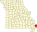
| County | Mississippi |
| Area | |
• Total | 0.26 sq mi (0.68 km2) |
| • Land | 0.26 sq mi (0.68 km2) |
| • Water | 0.00 sq mi (0.00 km2) |
| Elevation | 308 ft (94 m) |
| Population | |
• Total | 155 |
| • Density | 593.87/sq mi (229.36/km2) |
| ZIP Code | 63845 (East Prairie) |
| FIPS code | 29-79684 |
| GNIS feature ID | 2806415 [2] |
Whiting is an unincorporated community and census-designated place in Mississippi County, in the U.S. state of Missouri. [2] As of the 2020 census, the population was 155. [3]