
The geography of Alabama describes a state in the Southeastern United States in North America. It extends from high mountains to low valleys and sandy beaches. Alabama is 30th in size and borders four U.S. states: Mississippi, Tennessee, Georgia, and Florida. It also borders the Gulf of Mexico.

Comanche County is a county located in the U.S. state of Oklahoma. As of the 2020 census, the population was 121,125, making it the fifth-most populous county in Oklahoma. Its county seat is Lawton. The county was created in 1901 as part of Oklahoma Territory. It was named for the Comanche tribal nation.

Medicine Park is a town in Comanche County, Oklahoma, United States, situated in the Wichita Mountains near the entrance to the 60,000-acre (240 km2) Wichita Mountain Wildlife Refuge. Medicine Park has a long history as a vintage cobblestone resort town. Medicine Park is located near the city of Lawton and Fort Sill. It is an exurb, part of the Lawton Metropolitan Statistical Area. Many of the original structures are constructed of naturally formed cobblestones—these red granite cobblestones are unique to the Wichita Mountains. The population was 382 at the 2010 census.

The tallgrass prairie is an ecosystem native to central North America. Historically, natural and anthropogenic fire, as well as grazing by large mammals provided periodic disturbances to these ecosystems, limiting the encroachment of trees, recycling soil nutrients, and facilitating seed dispersal and germination. Prior to widespread use of the steel plow, which enabled large scale conversion to agricultural land use, tallgrass prairies extended throughout the American Midwest and smaller portions of southern central Canada, from the transitional ecotones out of eastern North American forests, west to a climatic threshold based on precipitation and soils, to the southern reaches of the Flint Hills in Oklahoma, to a transition into forest in Manitoba.

The Pantanal is a natural region encompassing the world's largest tropical wetland area, and the world's largest flooded grasslands. It is located mostly within the Brazilian state of Mato Grosso do Sul, but it extends into Mato Grosso and portions of Bolivia and Paraguay. It sprawls over an area estimated at between 140,000 and 195,000 km2. Various subregional ecosystems exist, each with distinct hydrological, geological and ecological characteristics; up to 12 of them have been defined.
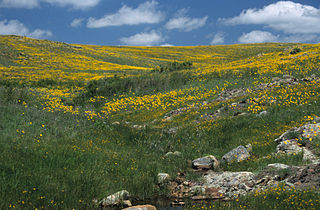
Wichita Mountains Wildlife Refuge, located in southwestern Oklahoma near Lawton, has protected unique wildlife habitats since 1901 and is the oldest managed wildlife facility in the United States Fish and Wildlife Service system. The refuge's location in the geologically unique Wichita Mountains and its areas of undisturbed mixed grass prairie make it an important conservation area. The Wichita Mountains are approximately 500 million years old. Measuring about 59,020 acres (238.8 km2), the refuge hosts a great diversity of species: 806 plant species, 240 species of birds, 36 fish, and 64 reptiles and amphibians are present.

Lake Jed Johnson, named for Jed Johnson (1888–1963), is third largest of thirteen small reservoirs in the Wichita Mountains National Wildlife Refuge, located in southwestern Oklahoma. Lawton, Oklahoma, southeast of the lake and the fourth largest city in the state, is the nearest major population center. Smaller communities of Cache, Medicine Park and Meers lie north of the lake.

Southwest Oklahoma is a geographical name for the southwest portion of the state of Oklahoma, typically considered to be south of the Canadian River, extending eastward from the Texas border to a line roughly from Weatherford, to Anadarko, to Duncan. Geologically, the region is defined by a failed continental rift known as the Southern Oklahoma Aulacogen. The austere nature of the prairie landscape with intermittent island ranges has made it a favorable place for artists and photographers alike. For tourism purposes, the Oklahoma Tourism and Recreation Department has designated Southwestern Oklahoma as Great Plains Country, and defined it to consist of 14 counties including Roger Mills, Custer, Beckham, Washita, Caddo, Kiowa, Greer, Harmon, Jackson, Comanche, Tillman, Cotton, Stephens, and Jefferson counties.

State Highway 115 is a 57.2 mile (92 km) long state highway in western Oklahoma, passing through Comanche, Kiowa, and Washita Counties as well as the Wichita Mountains Wildlife Refuge. The highway has no lettered spur routes.

Ladislavella utahensis, common name the thickshell pondsnail, is a species of air-breathing freshwater snail, an aquatic pulmonate gastropod mollusc in the family Lymnaeidae, the pond snails. This species is endemic to Utah Lake in the United States. The last living snails were found in the early 1930s.

The Chittenango ovate amber snail is a species of small air-breathing land snail in the family Succineidae, the amber snails. This species was discovered in 1905, and was reported three years later as a subspecies of the oval ambersnail, Succinea ovalis. Several taxonomic reviews took place in the subsequent decades until the end of the 1980s, when the Chittenango ovate amber snail was finally judged to be a distinct species based on chemical and morphological data.
The flat-spired three-toothed snail —also known as the Cheat three-toothed snail after the Cheat River in West Virginia—is a species of air-breathing land snail, a terrestrial pulmonate gastropod mollusk in the family Polygyridae.

The Little River is a tributary of the Red River, with a total length of 217 miles (349 km), 130 miles (210 km) within the Choctaw Indian Reservation in southeastern Oklahoma and 87 miles (140 km) in southwestern Arkansas in the United States. Via the Red, it is part of the watershed of the Mississippi River. Six large reservoirs impound the Little River and its tributaries. The drainage basin of the river totals 4,204 square miles (10,890 km2), 2,204 square miles (5,710 km2) in Oklahoma and 2,036 square miles (5,270 km2) in Arkansas. The Little River and its upper tributaries are popular for recreational canoeing and kayaking.

Euchemotrema is a genus of small, air-breathing land snails, terrestrial pulmonate gastropod mollusks in the family Polygyridae.

The Geography of Oklahoma encompasses terrain and ecosystems ranging from arid plains to subtropical forests and mountains. Oklahoma contains 10 distinct ecological regions, more per square mile than in any other state by a wide margin. It is situated in the Great Plains and U.S. Interior Highlands region near the geographical center of the 48 contiguous states. Usually considered part of the South Central United States, Oklahoma is bounded on the east by Arkansas and Missouri, on the north by Kansas, on the northwest by Colorado, on the far west by New Mexico, and on the south and near-west by Texas.
Mount Pinchot is the highest peak in the Wichita Mountains Wildlife Refuge of Southwest Oklahoma at 2,476 feet above sea level. It is located toward the western edge of the WMWR. The US Fish and Wildlife Service is responsible for the maintenance of the area. Mount Pinchot is located within the Wildlife Refuge's Special Use Area and is closed to the public. Special wildlife viewing tours are offered by the Refuge which take participants very near the base of the mountain.

Buenos Aires National Wildlife Refuge provides 117,107 acres (47,392 ha) of habitat for threatened and endangered plants and animals. This refuge, in Pima County, Arizona, was established in 1985.

The Central Great Plains are a semiarid prairie ecoregion of the central United States, part of North American Great Plains. The region runs from west-central Texas through west-central Oklahoma, central Kansas, and south-central Nebraska.
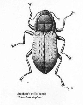
Heterelmis stephani was a rare species of aquatic beetle known by the common name Stephan's riffle beetle. It was endemic to Arizona in the United States, where it occurred in the Santa Rita Mountains before being declared presumed extinct. It was brown in color with small black dots on its wings.

Sonorella neglecta is a terrestrial pulmonate gastropod mollusc in the subfamily Helminthoglyptinae. Sonorella is a genus of large land snails consisting of over 80 species, with new ones continuing to be described. The shells typically differ only rather subtly, but proportions of the genitalia differentiate species. The genus is distributed in the southwestern USA and northern Mexico, with individual species often restricted to a single mountain massif or to a small part of one. Sonorella neglecta is such a narrow-range endemic from the Chiricahua Mountains. Its official vernacular name is the Portal Talussnail.
