Wielen

Last updated
Wielen
Germany adm location map.svg
Red pog.svg
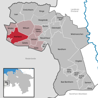
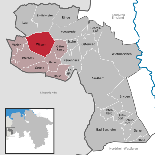
Wielen
Location of Wielen within Grafschaft Bentheim district
Grafschaft BentheimLower SaxonyNetherlandsEmslandNorth Rhine-WestphaliaBad BentheimOhneSamernSuddendorfSchüttorfQuendorfIsterbergEngdenNordhornWietmarschenGeorgsdorfOsterwaldLageHalleUelsenGeteloWielenItterbeckWielenRingeEmlichheimLaarWilsumGölenkampEscheNeuenhausHoogstedeWielen
Wielen
Coordinates: 52°33′N6°43′E / 52.550°N 6.717°E / 52.550; 6.717 Coordinates: 52°33′N6°43′E / 52.550°N 6.717°E / 52.550; 6.717
Country Germany
State Lower Saxony
District Grafschaft Bentheim
Municipal assoc. Uelsen
Government
   Mayor Gerold Stroeve
Area
  Total 23.06 km2 (8.90 sq mi)
Elevation 20 m (70 ft)
Population (2015-12-31) [1]
  Total 543
  Density 24/km2 (61/sq mi)
Time zone CET/CEST (UTC+1/+2)
Postal codes 49847
Dialling codes 0 59 48
Vehicle registration NOH
Website www.uelsen.de/samtgem/
fwielen.HTML

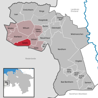
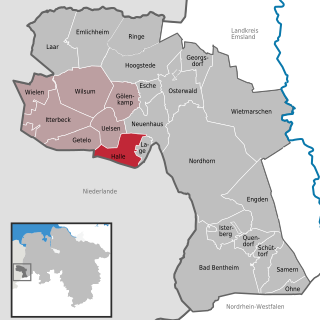
Wielen is a small village in the district of Grafschaft Bentheim in Lower Saxony, Germany, and belongs to the Joint Community (Samtgemeinde) of Uelsen. Wielen has 614 inhabitants. Within the village is found the Lower County’s oldest maintained school, het Schöltien.

Lower Saxony State in Germany

Lower Saxony is a German state (Land) situated in northwestern Germany. It is the second-largest state by land area, with 47,624 km2 (18,388 sq mi), and fourth-largest in population among the 16 Länder federated as the Federal Republic of Germany. In rural areas, Northern Low Saxon and Saterland Frisian are still spoken, but the number of speakers is declining.

Germany Federal parliamentary republic in central-western Europe

Germany, officially the Federal Republic of Germany, is a country in Central and Western Europe, lying between the Baltic and North Seas to the north, and the Alps, Lake Constance and the High Rhine to the south. It borders Denmark to the north, Poland and the Czech Republic to the east, Austria and Switzerland to the south, France to the southwest, and Luxembourg, Belgium and the Netherlands to the west.

Uelsen Place in Lower Saxony, Germany

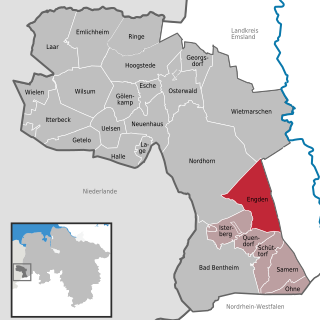
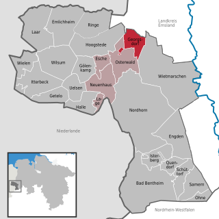
Uelsen is a community in the district of Grafschaft Bentheim in Lower Saxony.

Contents

Constituent communities

Along with the namesake Ortsteil , there are outlying centres named Balderhaar, Striepe and Vennebrügge.

Related Research Articles

Engden Place in Lower Saxony, Germany

Engden is a community in the district of the County of Bentheim in Lower Saxony.

Esche Place in Lower Saxony, Germany

Esche is a community in the district of Grafschaft Bentheim in Lower Saxony.

Georgsdorf Place in Lower Saxony, Germany

Georgsdorf is a community in the district of Grafschaft Bentheim in Lower Saxony.

Getelo Place in Lower Saxony, Germany

Getelo is a community in the district of Grafschaft Bentheim in Lower Saxony.

Gölenkamp Place in Lower Saxony, Germany

Gölenkamp is a community in the district of Grafschaft Bentheim in Lower Saxony.

Halle, Bentheim Place in Lower Saxony, Germany

Halle is a village in the Joint Community (Samtgemeinde) of Uelsen, in the district of Grafschaft Bentheim in Lower Saxony.

Hoogstede Place in Lower Saxony, Germany

Hoogstede is a community in the district of Grafschaft Bentheim in Lower Saxony.

Isterberg Place in Lower Saxony, Germany

The community of Isterberg in Lower Saxony’s district of Grafschaft Bentheim came into being in the 1970s through the amalgamation of the two former communities of Wengsel and Neerlage. It lies between Bad Bentheim and Nordhorn and belongs to the Joint Community (Samtgemeinde) of Schüttorf, whose administrative seat is in the like-named town.

Itterbeck Place in Lower Saxony, Germany

Itterbeck in the district of Grafschaft Bentheim in Lower Saxony is an old farming community that has developed into an independent community with almost 1,800 inhabitants (2005). Itterbeck belongs to the Joint Community (Samtgemeinde) of Uelsen, whose administrative seat is in the like-named community.

Laar Place in Lower Saxony, Germany

Laar is a community in the district of Grafschaft Bentheim in Lower Saxony. The community’s name comes from the Old Dutch for “glade in the woods”.

Ohne, Germany Place in Lower Saxony, Germany

Ohne is a community in the district of Grafschaft Bentheim in Lower Saxony, Germany.

Osterwald Place in Lower Saxony, Germany

Osterwald is a community and part of the Joint Community (Samtgemeinde) of Neuenhaus in the district of Grafschaft Bentheim in Lower Saxony. The community consists of the centres of Osterwald, Alte Piccardie and Hohenkörben.

Quendorf Place in Lower Saxony, Germany

Quendorf is a rural community belonging to the Joint Community of Schüttorf in southwestern Lower Saxony. There is no village centre. The community is made up of several settlements and scattered farms. In 1971, Quendorf joined the town of Schüttorf along with the communities of Drievorden, Engden, Neerlage, Ohne, Samern, Suddendorf and Wengsel into the Joint Community of Schüttorf.

Ringe, Germany Place in Lower Saxony, Germany

Ringe is a community in the district of Grafschaft Bentheim in Lower Saxony, Germany.

Samern Place in Lower Saxony, Germany

Samern is a community in the district of Grafschaft Bentheim in Lower Saxony, Germany.

Wilsum, Germany Place in Lower Saxony, Germany

Wilsum is a community in the district of Grafschaft Bentheim in Lower Saxony, Germany near the Dutch border, and it belongs to the Joint Community (Samtgemeinde) of Uelsen.

Girod, Germany Place in Rhineland-Palatinate, Germany

Girod is an Ortsgemeinde – a community belonging to a Verbandsgemeinde – in the Westerwaldkreis in Rhineland-Palatinate, Germany.

Hübingen Place in Rhineland-Palatinate, Germany

Hübingen is an Ortsgemeinde – a community belonging to a Verbandsgemeinde – in the Westerwaldkreis in Rhineland-Palatinate, Germany.

Dębogóra, Czarnków-Trzcianka County Village in Greater Poland, Poland

Dębogóra is a village in the administrative district of Gmina Wieleń, within Czarnków-Trzcianka County, Greater Poland Voivodeship, in west-central Poland. It lies approximately 10 kilometres (6 mi) north of Wieleń, 31 km (19 mi) west of Czarnków, and 84 km (52 mi) north-west of the regional capital Poznań.

References