An unincorporated area is a region that is not governed by a local municipal corporation. There are many unincorporated communities and areas in the United States and Canada.

Witten is a city with almost 100,000 inhabitants in the Ennepe-Ruhr-Kreis (district) in North Rhine-Westphalia, Germany.
Chełmek is a town in Lesser Poland Voivodeship in southern Poland. In 1975–1998 it belonged to Bielsko-Biała Voivodeship. As of December 2021, it has 8,810 inhabitants. Previously known for the Chełmek Shoe Factory, which until 1947 was part of Bata Shoes.

The German-speaking Community, also known as East Belgium, is one of the three federal communities of Belgium, with an area of 854 km2 (330 sq mi) in the Liège Province of Wallonia, including nine of the eleven municipalities of Eupen-Malmedy. The primary language of the community is German, making this one of the three official languages in Belgium. Traditionally the community and the wider area around it forms an intersection of various local languages and/or dialects, namely Limburgish, Ripuarian and Moselle Franconian varieties. The community population numbers around 79,000 – about 7.0% of Liège Province and about 0.7% of the national total.
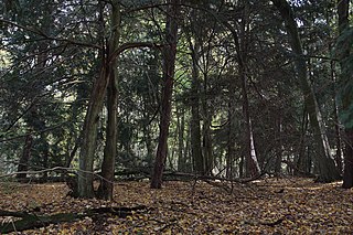
The Tuchola Forest, also known as Tuchola Pinewoods or Tuchola Conifer Woods, is a large forest complex near the town of Tuchola in northern Poland. It lies between the Brda and Wda rivers, within the Gdańsk Pomerania region. The largest towns in the area are Czersk and Tuchola.

Horb am Neckar is a town in the southwest of the German state of Baden-Württemberg. It is located on the Neckar river, between Offenburg to the west and Tübingen to the east. It has around 25,000 inhabitants, of whom about 6,000 live in the main town of Horb, and the remainder in 18 associated villages and districts which form part of the same municipality. If the entire municipality is counted, it is the largest town in the District of Freudenstadt.

Schüttorf is a town in the district of Grafschaft Bentheim in southwesternmost Lower Saxony near the Dutch border and the boundary with Westphalia. The town of Schüttorf forms with the surrounding communities the Joint Community (Samtgemeinde) of Schüttorf. It is the district's oldest town. It lies on the river Vechte, roughly 5 km east of Bad Bentheim, and 20 km southeast of Nordhorn.

Uelsen is a community in the district of Grafschaft Bentheim in Lower Saxony.

Szydłowiec is a town in Szydłowiec County, Mazovian Voivodeship, south-central Poland, with 5,243 inhabitants. It is the seat of Gmina Szydłowiec (commune). Szydłowiec is part of the historic region of Lesser Poland.
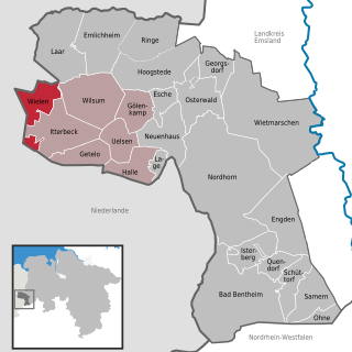
Wielen is a small village in the district of Grafschaft Bentheim in Lower Saxony, Germany, and belongs to the Joint Community (Samtgemeinde) of Uelsen. Wielen has 614 inhabitants. Within the village is found the Lower County’s oldest maintained school, het Schöltien.
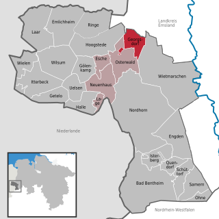
Georgsdorf is a community in the district of Grafschaft Bentheim in Lower Saxony.

Gölenkamp is a community in the district of Grafschaft Bentheim in Lower Saxony.
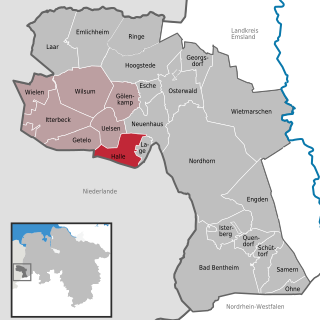
Halle is a village in the Joint Community (Samtgemeinde) of Uelsen, in the district of Grafschaft Bentheim in Lower Saxony.
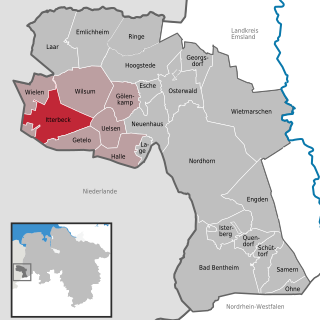
Itterbeck in the district of Grafschaft Bentheim in Lower Saxony is an old farming community that has developed into an independent community with almost 1,800 inhabitants (2005). Itterbeck belongs to the Joint Community (Samtgemeinde) of Uelsen, whose administrative seat is in the like-named community.

Laar is a community in the district of Grafschaft Bentheim in Lower Saxony. The community’s name comes from the Old Dutch for “glade in the woods”.

Ohne is a community in the district of Grafschaft Bentheim in Lower Saxony, Germany.
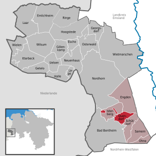
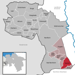
Quendorf is a rural community belonging to the Joint Community of Schüttorf in southwestern Lower Saxony. There is no village centre. The community is made up of several settlements and scattered farms. In 1971, Quendorf joined the town of Schüttorf along with the communities of Drievorden, Engden, Neerlage, Ohne, Samern, Suddendorf and Wengsel into the Joint Community of Schüttorf.

Ringe is a community in the district of Grafschaft Bentheim in Lower Saxony, Germany.

Nentershausen is an Ortsgemeinde – a community belonging to a Verbandsgemeinde – in the Westerwaldkreis in Rhineland-Palatinate, Germany.

The Augsburger Verkehrs- und Tarifverbund or AVV is the transit authority of the city of Augsburg, located in Swabia, Bavaria, Germany. Its jurisdiction covers the city and its surrounding area, responsible for the commuter trains, the Augsburg tramway and buses.