Engden

Last updated
Engden
Location of Engden within County of Bentheim district
Engden in NOH.svgOhneLageHalleRingeWilsumEsche
Germany adm location map.svg
Red pog.svg
Engden
Lower Saxony location map.svg
Red pog.svg
Engden
Coordinates: 52°24′N07°11′E / 52.400°N 7.183°E / 52.400; 7.183 Coordinates: 52°24′N07°11′E / 52.400°N 7.183°E / 52.400; 7.183
Country Germany
State Lower Saxony
District County of Bentheim
Municipal assoc. Schüttorf
Subdivisions2 centres
Government
   Mayor Gerhard Theißing (CDU)
Area
  Total44.29 km2 (17.10 sq mi)
Elevation
29 m (95 ft)
Population
 (2020-12-31) [1]
  Total409
  Density9.2/km2 (24/sq mi)
Time zone UTC+01:00 (CET)
  Summer (DST) UTC+02:00 (CEST)
Postal codes
48465
Dialling codes 0 59 26
Vehicle registration NOH

Engden is a community in the district of the County of Bentheim in Lower Saxony.

Contents

Geography

Location

Engden lies between Nordhorn and Schüttorf. It belongs to the Joint Community (Samtgemeinde) of Schüttorf, whose administrative seat is in the like-named town.

Politics

Engden was and is dominated by a Catholic church milieu, and as such, markedly few Engdeners opted for the NSDAP in Nazi times.

Mayor

The honorary mayor Gerhard Theißing was elected on 9 September 2001.

Culture and sightseeing

Buildings

The Katholische Kirche Abt St. Antonius (church) was built in 1899 as a neo-Romanesque brick structure.


The Dobbe warehouse may have been built about 1800 and is said to be northwest Germany’s oldest maintained rural grain distillery building, and as such it is an important industrial monument.

The Bügeleisen-Haus, or Clothes Iron House, came to be because the farmers would only relinquish to the house builder a narrow, tapered lot whose odd layout has resulted in the house's having no right angles at all. Building work began on the house “about 1900”, but it was finished only after the First World War.

Economy and infrastructure

Transport

Autobahnen A 31 and A 30 lie 6 km from the community and are easily reached.

Curiosity

Children from Engden go to school or kindergarten in Emsbüren, in another district.

Related Research Articles

<span class="mw-page-title-main">Steinfurt</span> Town in North Rhine-Westphalia, Germany

Steinfurt is a city in North Rhine-Westphalia, Germany. It is the capital of the district of Steinfurt. From roughly 1100-1806, it was the capital of the County of Steinfurt.

<span class="mw-page-title-main">Freudenstadt</span> Town in Baden-Württemberg, Germany

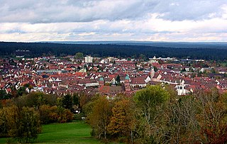
Freudenstadt is a town in Baden-Württemberg in southern Germany. It is capital of the district Freudenstadt. The closest population centres are Offenburg to the west and Tübingen to the east.

<span class="mw-page-title-main">Nordhorn</span> Town in Lower Saxony, Germany

Nordhorn is a town in Lower Saxony, Germany. It is the district seat of Grafschaft Bentheim in Lower Saxony's southwesternmost corner near the border with the Netherlands and the boundary with North Rhine-Westphalia.

<span class="mw-page-title-main">Bad Bentheim</span> Place in Lower Saxony, Germany

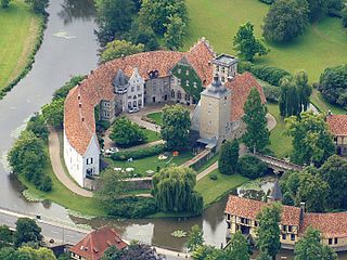
Bad Bentheim is a town in the southwestern part of Lower Saxony, Germany, in the district of Grafschaft Bentheim on the borders of North Rhine-Westphalia and the Netherlands roughly 15 km south of Nordhorn and 20 km northeast of Enschede. It is also a state-recognized thermal brine and sulphur spa town, hence the designation Bad (“Bath”). Also to be found in Bad Bentheim is the castle Burg Bentheim, the town's emblem.

<span class="mw-page-title-main">Emlichheim</span> Municipality in Lower Saxony, Germany

Emlichheim is a municipality in the district of Grafschaft Bentheim in Lower Saxony, Germany, roughly 20 km south of Emmen, and 25 km northwest of Nordhorn.

<span class="mw-page-title-main">Neuenhaus</span> Town in Lower Saxony, Germany

Neuenhaus is a town in the district of Grafschaft Bentheim in Lower Saxony, and is the seat of a like-named collective municipality Neuenhaus. Neuenhaus lies on the rivers Dinkel and Vechte near the border with the Netherlands and is roughly 10 km northwest of Nordhorn, and 30 km north of Enschede.

<span class="mw-page-title-main">Schüttorf</span> Town in Lower Saxony, Germany

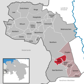
Schüttorf is a town in the district of Grafschaft Bentheim in southwesternmost Lower Saxony near the Dutch border and the boundary with Westphalia. The town of Schüttorf forms with the surrounding communities the Joint Community (Samtgemeinde) of Schüttorf. It is the district's oldest town. It lies on the river Vechte, roughly 5 km east of Bad Bentheim, and 20 km southeast of Nordhorn.

<span class="mw-page-title-main">Uelsen</span> Municipality in Lower Saxony, Germany

Uelsen is a community in the district of Grafschaft Bentheim in Lower Saxony.

<span class="mw-page-title-main">Wietmarschen</span> Municipality in Lower Saxony, Germany

Wietmarschen is a unitary municipality (Einheitsgemeinde) in the district of Grafschaft Bentheim in Lower Saxony, Germany. It is split into the villages of Wietmarschen, Füchtenfeld, Schwartenpohl, Lohnerbruch, Nordlohne and Lohne with Lohne being the biggest and having the town hall while Wietmarschen, which is the second biggest, having the name.

<span class="mw-page-title-main">Esche, Lower Saxony</span> Municipality in Lower Saxony, Germany

Esche is a community in the district of Grafschaft Bentheim in Lower Saxony.

<span class="mw-page-title-main">Georgsdorf</span> Municipality in Lower Saxony, Germany

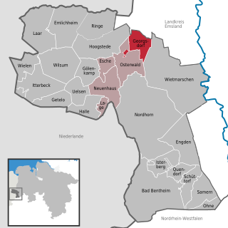
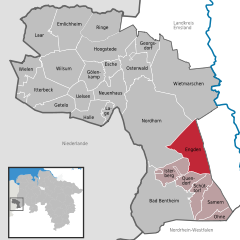
Georgsdorf is a community in the district of Grafschaft Bentheim in Lower Saxony.

<span class="mw-page-title-main">Getelo</span> Municipality in Lower Saxony, Germany

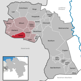
Getelo is a community in the district of Grafschaft Bentheim in Lower Saxony.

<span class="mw-page-title-main">Gölenkamp</span> Municipality in Lower Saxony, Germany

Gölenkamp is a community in the district of Grafschaft Bentheim in Lower Saxony.

<span class="mw-page-title-main">Hoogstede</span> Municipality in Lower Saxony, Germany

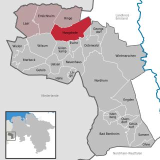
Hoogstede is a community in the district of Grafschaft Bentheim in Lower Saxony.

<span class="mw-page-title-main">Isterberg</span> Municipality in Lower Saxony, Germany

The community of Isterberg, in Lower Saxony’s district of Grafschaft Bentheim, came into being in the 1970s, through the amalgamation of the two former communities of Wengsel and Neerlage. It lies between Bad Bentheim and Nordhorn, and is part of the Samtgemeinde of Schüttorf.

<span class="mw-page-title-main">Laar</span> Municipality in Lower Saxony, Germany

Laar is a community in the district of Grafschaft Bentheim in Lower Saxony. The community’s name comes from the Old Dutch for “glade in the woods”.

<span class="mw-page-title-main">Lage, Lower Saxony</span> Municipality in Lower Saxony, Germany

Lage is a community on the river Dinkel in the district of Grafschaft Bentheim in Lower Saxony with roughly 1,000 inhabitants. It belongs to the Joint Community (Samtgemeinde) of Neuenhaus.

<span class="mw-page-title-main">Ohne, Germany</span> Municipality in Lower Saxony, Germany

Ohne is a community in the district of Grafschaft Bentheim in Lower Saxony, Germany.

<span class="mw-page-title-main">Quendorf</span> Municipality in Lower Saxony, Germany

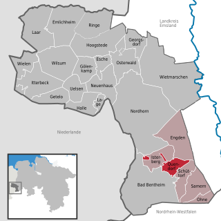
Quendorf is a rural community belonging to the Joint Community of Schüttorf in southwestern Lower Saxony. There is no village centre. The community is made up of several settlements and scattered farms. In 1971, Quendorf joined the town of Schüttorf along with the communities of Drievorden, Engden, Neerlage, Ohne, Samern, Suddendorf and Wengsel into the Joint Community of Schüttorf.

<span class="mw-page-title-main">Samern</span> Municipality in Lower Saxony, Germany

Samern is a community in the district of Grafschaft Bentheim in Lower Saxony, Germany.

References

Further reading