Itterbeck

Last updated
Itterbeck
Wappen der Gemeinde Itterbeck.svg
Location of Itterbeck within Grafschaft Bentheim district
Itterbeck in NOH.svgOhneLageHalleRingeWilsumEsche
Germany adm location map.svg
Red pog.svg
Itterbeck
Lower Saxony location map.svg
Red pog.svg
Itterbeck
Coordinates: 52°30′23″N6°48′10″E / 52.50639°N 6.80278°E / 52.50639; 6.80278 Coordinates: 52°30′23″N6°48′10″E / 52.50639°N 6.80278°E / 52.50639; 6.80278
Country Germany
State Lower Saxony
District Grafschaft Bentheim
Municipal assoc. Uelsen
Subdivisions7 Ortsteile
Government
   Mayor Lambertus Wanink
Area
  Total41.01 km2 (15.83 sq mi)
Elevation
39 m (128 ft)
Population
 (2021-12-31) [1]
  Total1,732
  Density42/km2 (110/sq mi)
Time zone UTC+01:00 (CET)
  Summer (DST) UTC+02:00 (CEST)
Postal codes
49847
Dialling codes 05948
Vehicle registration NOH
Website www.itterbeck.net

Itterbeck in the district of Grafschaft Bentheim in Lower Saxony is an old farming community that has developed into an independent community with almost 1,800 inhabitants (2005). Itterbeck belongs to the Joint Community (Samtgemeinde) of Uelsen, whose administrative seat is in the like-named community.

Contents

The name Itterbeck springs from the brook that runs through the community, called the Itter. The Itterbeck landscape is marked by heath, woods and cultivated moorland. In the outlying centre of Egge is found an Evangelical Reformed chapel that belongs to the parish of Uelsen. Worth seeing are the nature reserve and Flora Fauna Habitat Itterbecker Heide (heath) and the Egger Riese (“Egge Giant”), an ice-age glacial erratic several metres high. In 2004, Itterbeck celebrated its 750th birthday.

Itterbeck's constituent communities ( Ortsteile ) are Itterbeck, Egge, Itterbeckermoor, Kleine Striepe, Balderhaarmoor, Itterbeckerdoose and Ratzel.

Politics

Since the municipal election on 10 August 2006, the community council has consisted of eleven councillors, one woman and ten men. The mayor is Lambertus Warnink.

Education and social services

Itterbeck has one elementary school. All further learning is handled by schools in neighbouring Uelsen. For younger children, the community has two play groups: in Itterbeck “Wonneproppen” and in Egge the “Egger Zwerge” (“Egge Dwarves”). Since 2001, there has moreover been in Egge a toddlers’ group (a Loslösegruppe in German) which cares for children from 2½ years on up. For older children there is an independent youth meeting place as well as children's afternoon groups organized by the YMCA and the Reformed church parish.

Leisure

Itterbeck has at its disposal extensive cycling and hiking paths which lead either through the community or throughout the whole Lower County. Popular outing destinations are the Egger Riese, the Itterbeck Heath and the sources of the Itter. For some time, the Hof für Heimatpflege (“Yard for Homeland Fostering”), which brings Itterbeck's past back to life, has been drawing many visitors under its spell. A costume group belongs to this, and wears authentic, historic Itterbeck costumes.

Furthermore, tennis courts, football fields and a wading pool are also open to public use in the community.

Related Research Articles

<span class="mw-page-title-main">Heidekreis</span> District in Lower Saxony, Germany

Heidekreis is a district (Landkreis) in Lower Saxony, Germany. It is bounded by the districts of Harburg, Lüneburg, Uelzen, Celle, Hanover, Nienburg, Verden and Rotenburg.

<span class="mw-page-title-main">Großostheim</span> Municipality in Bavaria, Germany

Großostheim is a market community in the Aschaffenburg district in the Regierungsbezirk of Lower Franconia (Unterfranken) in Bavaria, Germany. The inhabitants call themselves Aistmer (ostheimers).

<span class="mw-page-title-main">Petersfield</span> Human settlement in England

Petersfield is a market town and civil parish in the East Hampshire district of Hampshire, England. It is 15 miles (24 km) north of Portsmouth. The town has its own railway station on the Portsmouth Direct line, the mainline rail link connecting Portsmouth and London. Situated below the northern slopes of the South Downs, Petersfield lies wholly within the South Downs National Park.

<span class="mw-page-title-main">Soltau</span> Town in Lower Saxony, Germany

Soltau is a mid-sized town in the Lüneburg Heath in the district of Heidekreis, in Lower Saxony, Germany. It has around 22,000 inhabitants. The city is centrally located in the Lüneburg Heath and is known nationwide especially for its tourist attractions like the Heide-Park and the Soltau-Therme.

<span class="mw-page-title-main">Bad Fallingbostel</span> Town in Lower Saxony, Germany

Bad Fallingbostel is the district town (Kreisstadt) of the Heidekreis district in the German state of Lower Saxony. Since 1976 the town has had a state-recognised Kneipp spa and has held the title of Bad since 2002. It has close ties to Walsrode, a few miles to the west. Until 2015, there was a British Army base in Bad Fallingbostel, It also hosted Defender 2020, the largest US Army/NATO exercise since the Cold War. The town has around 11,000 inhabitants.

<span class="mw-page-title-main">Bergen, Lower Saxony</span> Town in Lower Saxony, Germany

Bergen is a town in the north of Celle district on the Lüneburg Heath, in Lower Saxony, Germany. Administratively it acts as a municipal borough divided into 12 subordinate parishes based on the town and its surrounding villages: Becklingen, Belsen, Bergen, Bleckmar, Diesten, Dohnsen, Eversen, Hagen, Hassel, Offen, Sülze and Wardböhmen. Bergen-Belsen concentration camp was located in the area of Belsen.

<span class="mw-page-title-main">Neuenhaus</span> Town in Lower Saxony, Germany

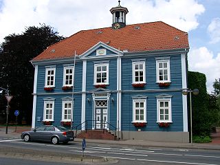
Neuenhaus is a town in the district of Grafschaft Bentheim in Lower Saxony, and is the seat of a like-named collective municipality Neuenhaus. Neuenhaus lies on the rivers Dinkel and Vechte near the border with the Netherlands and is roughly 10 km northwest of Nordhorn, and 30 km north of Enschede.

<span class="mw-page-title-main">Schüttorf</span> Town in Lower Saxony, Germany

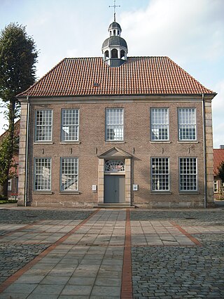
Schüttorf is a town in the district of Grafschaft Bentheim in southwesternmost Lower Saxony near the Dutch border and the boundary with Westphalia. The town of Schüttorf forms with the surrounding communities the Joint Community (Samtgemeinde) of Schüttorf. It is the district's oldest town. It lies on the river Vechte, roughly 5 km east of Bad Bentheim, and 20 km southeast of Nordhorn.

<span class="mw-page-title-main">Waldshut-Tiengen</span> Town in Baden-Württemberg, Germany

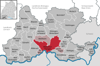
Waldshut-Tiengen, commonly known as Waldshut, is a city in southwestern Baden-Württemberg right at the Swiss border. It is the district seat and at the same time the biggest city in Waldshut district and a "middle centre" in the area of the "high centre" Lörrach/Weil am Rhein to whose middle area most towns and communities in Waldshut district belong. There are furthermore complexities arising from cross-border traffic between this area and the Swiss cantons of Aargau, Schaffhausen and Zürich. This classification relates to Walter Christaller's Central Place Theory, however, and not to any official administrative scheme.

<span class="mw-page-title-main">Vöhl</span> Municipality in Hesse, Germany

Vöhl is a municipality in Waldeck-Frankenberg in Hesse, Germany, not far southwest of Kassel.

<span class="mw-page-title-main">Getelo</span> Municipality in Lower Saxony, Germany

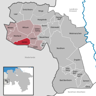
Getelo is a community in the district of Grafschaft Bentheim in Lower Saxony.

<span class="mw-page-title-main">Gölenkamp</span> Municipality in Lower Saxony, Germany

Gölenkamp is a community in the district of Grafschaft Bentheim in Lower Saxony.

<span class="mw-page-title-main">Halle, Bentheim</span> Municipality in Lower Saxony, Germany

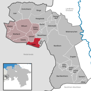
Halle is a village in the Joint Community (Samtgemeinde) of Uelsen, in the district of Grafschaft Bentheim in Lower Saxony.

<span class="mw-page-title-main">Laar</span> Municipality in Lower Saxony, Germany

Laar is a community in the district of Grafschaft Bentheim in Lower Saxony. The community’s name comes from the Old Dutch for “glade in the woods”.

<span class="mw-page-title-main">Wilsum, Germany</span> Municipality in Lower Saxony, Germany

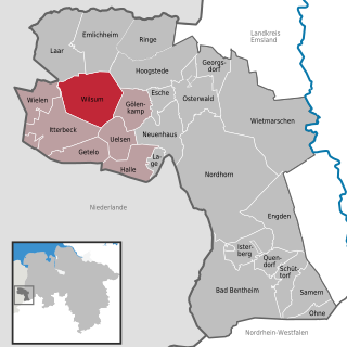
Wilsum is a community in the district of Grafschaft Bentheim in Lower Saxony, Germany near the Dutch border, and it belongs to the Joint Community (Samtgemeinde) of Uelsen.

<span class="mw-page-title-main">Handeloh</span> Municipality in Lower Saxony, Germany

Handeloh is a municipality in the district of Harburg, in Lower Saxony, Germany.

<span class="mw-page-title-main">Becklingen</span> Ortsteil of Bergen in Lower Saxony, Germany

Becklingen is a German village in the Lower Saxon borough of Bergen in the northern part of Celle district on the Lüneburg Heath. Formerly an independent municipality, it is part of the town Bergen since 1971.

<span class="mw-page-title-main">Bleckmar</span> Ortsteil of Bergen in Lower Saxony, Germany

Bleckmar is a village administered by the Lower Saxon town of Bergen in the northern part of Celle district on the Lüneburg Heath in North Germany. It lies about 3 kilometres (1.9 mi) north of Bergen on the B 3 federal road and has 464 inhabitants (2019). It is administratively responsible for the neighbouring hamlet of Dageförde.

Eversen is a village in the town of Bergen in the northern part of Celle district on the Lüneburg Heath in the north German state of Lower Saxony.

<span class="mw-page-title-main">Hassel (Bergen)</span> Ortsteil of Bergen in Lower Saxony, Germany

Hassel is a village administered by the Lower Saxon town of Bergen in the northern part of Celle district on the Lüneburg Heath in North Germany. Formerly an independent municipality, it is part of the town Bergen since 1973.

References

  1. "LSN-Online Regionaldatenbank, Tabelle A100001G: Fortschreibung des Bevölkerungsstandes, Stand 31. Dezember 2021" (in German). Landesamt für Statistik Niedersachsen.