
Sandwich is a town and civil parish in the Dover District of Kent, south-east England. It lies on the River Stour and has a population of 4,985. Sandwich was one of the Cinque Ports and still has many original medieval buildings, including several listed public houses and gates in the old town walls, churches, almshouses and the White Mill. While once a major port, it is now 2 miles (3 km) from the sea due to the disappearance of the Wantsum Channel. Its historic centre has been preserved. Sandwich Bay is home to nature reserves and two world-class golf courses, Royal St George's and Prince's. The town is also home to many educational and cultural events. Sandwich also gave its name to the food by way of John Montagu, 4th Earl of Sandwich, and the word sandwich is now found in several languages.

Events from the year 1847 in Canada.

Meopham is a large linear village and civil parish in the Borough of Gravesham in north-west Kent, England, lying to the south of Gravesend. The parish covers 6.5 square miles (17 km2), and comprises two villages and two smaller settlements; it had a population of 6,795 at the 2021 census. Meopham village is sometimes described as the longest settlement in England although others such as Brinkworth which is one village make the same claim. Meopham is one of the longest linear settlements in Europe, being 7 miles (11 km) in length.

Trnje is a district in the City of Zagreb, Croatia. According to the 2011 census, the district had 42,282 residents. It is located in the central part of the city, south of Donji grad across the railway, east of Trešnjevka, west of Peščenica, and north of the river Sava. The Slavonska Avenue intersects Trnje.

Winterbourne Monkton is a small village and civil parish in Wiltshire, England, about 1 mile (1.6 km) north of Avebury Stone Circle and 6 miles (10 km) northwest of Marlborough.

Bangui, officially the Municipality of Bangui, is a 4th class municipality in the province of Ilocos Norte, Philippines. According to the 2020 census, it has a population of 15,019 people.
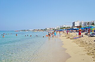
Paralimni is a town within the Famagusta District of Cyprus, situated on the island's east coast. Since the Turkish invasion in 1974, it has increased in size and status, primarily due to the migration of refugees fleeing from the north. Many workers in the tourist sectors of Protaras and Ayia Napa live in Paralimni, which is now the temporary administrative centre of the Famagusta District and the biggest municipality of the district under the control of the Republic of Cyprus.

Newcastle City Council is the local authority for the city of Newcastle upon Tyne the ceremonial county of Tyne and Wear in North East England. Newcastle has had a council from medieval times, which has been reformed on numerous occasions. Since 1974 the council has been a metropolitan borough council. It has been under Labour majority control since 2011. In 2024 the council became a member of the North East Combined Authority. The council is based at Newcastle Civic Centre.

Clanfield is a village and civil parish in the south-east of the East Hampshire district of Hampshire, England. It is situated 2.4 miles north of Horndean, 12 mi (19 km) north of Portsmouth and 6 mi (10 km) south of Petersfield. It sits to the west of the main A3 road, just north of where the A3(M) (Motorway) ends.

Hille is a community in the Kreis Minden-Lübbecke in the north of East Westphalia, Germany, with approximately 16,000 inhabitants. It was created in 1973 in the framework of the community restructuring of North Rhine-Westphalia through the combining of nine communities of the Minden countryside. The community is named after Hille its largest village. The geography of the community belongs to that of the North German Plain, from its lowest altitude of 45 metres it rises to 251 metres on the ridge of the Wiehengebirge at its southern border.

Stembridge Tower Mill in High Ham, Somerset, England, is the last remaining thatched windmill in England. The mill is a grade II* listed building.

Osterwald is a community and part of the Joint Community (Samtgemeinde) of Neuenhaus in the district of Grafschaft Bentheim in Lower Saxony. The community consists of the centres of Osterwald, Alte Piccardie and Hohenkörben.

Samern is a community in the district of Grafschaft Bentheim in Lower Saxony, Germany.

Courcelles-lès-Lens is a commune in the Pas-de-Calais department in the Hauts-de-France region of France.
Ally is a commune in the Cantal department in the Auvergne region of south-central France.

Cley Windmill is a Grade II* listed tower mill at Cley next the Sea, Norfolk, England which has been converted to residential accommodation.

Mountnessing Windmill is a grade II* listed post mill at Mountnessing, Essex, England. Built in 1807, it was most recently restored to working order in 1983.
The 2006 Halton Borough Council election took place on 4 May 2006 to elect members of Halton Unitary Council in Cheshire, England. One third of the council was up for election and the Labour Party stayed in overall control of the council.
Jews' Gate Cemetery is a Jewish cemetery located on Windmill Hill within a nature reserve in the British Overseas Territory of Gibraltar. Also known as the Windmill Hill Cemetery, it is the site of the earliest known Jewish burials in Gibraltar. The cemetery opened by 1746 and closed in 1848. It is the burial site of a number of Gibraltar's Chief Rabbis. The graveyard is protected by the law of Gibraltar.

The Velebit Channel is a channel in Croatia located between the lands at the foot of the Velebit mountain range and the islands of Pag, Rab, Goli Otok, Prvić and Krk. It is about 121 kilometres long, with an average width of 3–4 km (1.9–2.5 mi) and up to 106 metres deep.


