
Willacy County is a county in the U.S. state of Texas. As of the 2020 census, its population was 20,164. Its county seat is Raymondville. The county was created in 1911 and organized the next year.

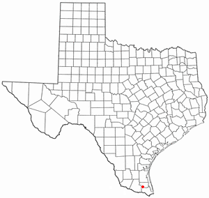
Laureles is a census-designated place (CDP) in Cameron County, Texas, United States. The population was 4,111 at the 2020 census. It is part of the Brownsville–Harlingen Metropolitan Statistical Area. Laureles is an area between Los Fresnos and San Benito.

Villa del Sol is a census-designated place (CDP) in Cameron County, Texas, United States. The population was 153 at the 2020 census. It is part of the Brownsville–Harlingen Metropolitan Statistical Area.

Yznaga is a census-designated place (CDP) in Cameron County, Texas, United States. The population was 108 at the 2020 census. It is part of the Brownsville–Harlingen Metropolitan Statistical Area.
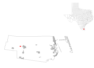
Agua Dulce is an unincorporated community and census-designated place (CDP) in El Paso County, Texas, United States. The population was 3,218 at the 2020 census. It is part of the El Paso Metropolitan Statistical Area. The ZIP Code encompassing the CDP area is 79928.

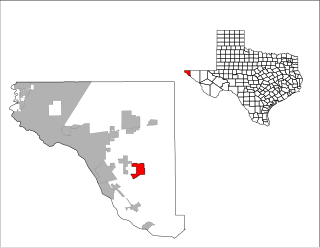
Morning Glory is a census-designated place (CDP) in El Paso County, Texas, United States. The population was 522 at the 2020 census, down from 651 at the 2010 census. It is part of the El Paso Metropolitan Statistical Area. The ZIP Code encompassing the CDP area is 79836.

North Alamo is a census-designated place (CDP) in Hidalgo County, Texas, United States. The population was 3,722 at the 2020 United States Census. It is part of the McAllen–Edinburg–Mission Metropolitan Statistical Area.

Loma Linda East is a census-designated place (CDP) in Jim Wells County, Texas, United States. The population was 305 at the 2020 census, up from 254 at the 2010 census.

Del Sol-Loma Linda is a former census-designated place (CDP) in San Patricio County, Texas, United States. The population was 726 at the 2000 U.S. Census.

Elbert is a census-designated place (CDP) in Throckmorton County, Texas, United States. The population was 29 at the 2020 census.
Bausell and Ellis is a former census-designated place (CDP) in Willacy County, Texas, United States. The population was 112 at the 2000 census.

Lasara is a census-designated place (CDP) in Willacy County, Texas, United States. The population was 909 at the 2020 census.

Los Angeles is a census-designated place (CDP) in Willacy County, Texas, United States. The population was 108 at the 2020 census. Prior to the 2010 census, the CDP was known as Los Angeles Subdivision.

Lyford South is an unincorporated community in Willacy County, Texas, United States. It was formerly classified as a census-designated place (CDP). The population was 172 at the 2000 census.

Port Mansfield is a census-designated place (CDP) in Willacy County, Texas, United States. The population was 226 at the 2010 census.
Ranchette Estates is a census-designated place (CDP) in Willacy County, Texas, United States. The population was 106 at the 2020 census.

Santa Monica is a census-designated place (CDP) in Willacy County, Texas, United States. The population was 86 at the 2020 census.
Sebastian is a census-designated place (CDP) in Willacy County, Texas, United States. The population was 1,684 at the 2020 census.

Zapata Ranch is a census-designated place (CDP) in Willacy County, Texas, United States. The population was 87 at the 2020 census.

Serenada is a census-designated place (CDP) in Williamson County, Texas, United States. The population was 2,098 at the 2020 census. Those living in Serenada have Georgetown addresses.


