Related Research Articles

Butterfield is a city in Butterfield Township, Barry County, Missouri, United States. The population was 378 at the 2020 census.

Chain-O-Lakes is a village in Roaring River Township of southeast Barry County, Missouri, United States. The population was 126 at the 2010 census.
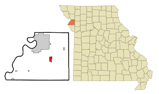
Agency is a village in Buchanan County, Missouri, United States. The population was 671 at the 2020 census. It is part of the St. Joseph, MO–KS Metropolitan Statistical Area.

Lewis and Clark Village is a village in Buchanan County, Missouri, United States. The population was 96 at the 2020 census. It is part of the St. Joseph, MO–KS Metropolitan Statistical Area.

Rushville is a village in western Buchanan County, Missouri, United States. The population was 225 at the 2020 census. It is part of the St. Joseph, MO–KS Metropolitan Statistical Area.

Wayland is a city in Clark County, Missouri, United States. As of the 2020 census, its population was 408. It is part of the Fort Madison–Keokuk, IA-MO Micropolitan Statistical Area.

Parkway is a village in Franklin County, Missouri, United States. The population was 439 at the 2010 census.

Imperial is a census-designated place (CDP) in Jefferson County, Missouri, United States, and is a suburb of St. Louis. The population was 4,947 at the 2020 census. Imperial was originally known as West Kimmswick, the historic Catholic church of St. John’s in Imperial, became an independent parish in 1869.

Fountain N' Lakes is a village in Lincoln County, Missouri, United States. The population was 165 at the 2010 census.
Leawood is a village in Newton County, Missouri, United States. The population was 682 at the 2010 census. It is part of the Joplin, Missouri Metropolitan Statistical Area.

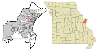
Bellerive Acres is a northern suburban city in St. Louis County, Missouri, United States. The population was 188 at the 2010 census. In April, 2015, the residents voted to change the village of Bellerive to a fourth class city named Bellerive Acres.

Country Life Acres is a village in St. Louis County, Missouri, United States. The population was 72 at the 2020 census.

Norwood Court is a village in St. Louis County, Missouri, United States. The population was 959 at the 2010 census.

Pasadena Park is a village in St. Louis County, Missouri, United States. The population was 470 at the 2010 census. It is part of the Normandy School District, and is distinct from the city of Pasadena Hills.
Sycamore Hills is a village in St. Louis County, Missouri, United States. The population is 560 at the 2020 census.

Velda Village Hills is a city in northeastern St. Louis County, Missouri, United States. The population was 1,055 at the 2010 census.

Wilbur Park is a village in St. Louis County, Missouri, United States. The population was 439 at the 2020 census.
McCord Bend is a village in Stone County, Missouri, United States. The population was 212 at the 2020 census. It is part of the Branson, Missouri Micropolitan Statistical Area.

Uplands Park is a village in St. Louis County, Missouri, United States. The population was 445 at the 2010 census. The village is one of many small majority black communities located in the Natural Bridge corridor of mid-St. Louis County, characterized by small homes on small lots.

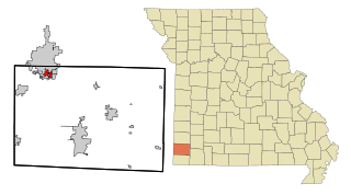
Windsor is a city in Henry and Pettis counties, Missouri, United States. The population was 2,901 at the 2010 census.
References
- ↑ "ArcGIS REST Services Directory". United States Census Bureau. Retrieved August 28, 2022.
- 1 2 U.S. Geological Survey Geographic Names Information System: Windsor Place, Missouri
- ↑ "Windsor Place MO ZIP Code". zipdatamaps.com. 2023. Retrieved June 16, 2023.
- ↑ "2007 New Incorporations" (TXT). Geography Division, United States Census Bureau. May 19, 2006. Retrieved July 13, 2008.
- ↑ Booneville, MO, 7.5 Minute Topographic Quadrangle, USGS, 2011
- ↑ "US Gazetteer files 2010". United States Census Bureau . Retrieved July 8, 2012.
- ↑ "Census of Population and Housing". Census.gov. Retrieved June 4, 2015.
- ↑ "U.S. Census website". United States Census Bureau . Retrieved July 8, 2012.
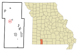
Municipalities and communities of Cooper County, Missouri, United States | ||
|---|---|---|
| Cities |  | |
| Villages | ||
| Townships | ||
| Unincorporated communities | ||
| | This Cooper County, Missouri state location article is a stub. You can help Wikipedia by expanding it. |