| Wistow | |
|---|---|
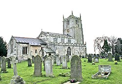
 Wistow Centre | |
 Wistow Location within North Yorkshire | |
| Population | 1,333 (2011 census) [1] |
| OS grid reference | SE592356 |
| Unitary authority | |
| Ceremonial county | |
| Region | |
| Country | England |
| Sovereign state | United Kingdom |
| Post town | SELBY |
| Postcode district | YO8 |
| Dialling code | 01757 |
| Police | North Yorkshire |
| Fire | North Yorkshire |
| Ambulance | Yorkshire |
Wistow is a small village and civil parish just north of Selby, North Yorkshire, England. In the 2011 Census it had 1,333 residents; [1] an increase from 2001 when there was 1,135. [2]
Contents
It was historically part of the West Riding of Yorkshire until 1974. [3] From 1974 to 2023 it was part of the district of Selby. It is now administered by the unitary North Yorkshire Council.