
The City of Shoalhaven is a local government area in the South Coast region of New South Wales, Australia. The area is about 200 kilometres (120 mi) south of Sydney. The Princes Highway passes through the area, and the South Coast railway line traverses the northern section, terminating at Bomaderry. At the 2021 census, the population was 108,531.

Nowra is a city in the South Coast region of New South Wales, Australia. It is located 160 kilometres (99 mi) south-southwest of the state capital of Sydney. As of the 2021 census, Nowra has an estimated population of 22,584. Situated in the southern reaches of the Sydney basin, Nowra is the seat and commercial centre of the City of Shoalhaven.

The Illawarra is a coastal region in the southeast of the Australian state of New South Wales, nestled between the mountains and the sea. It is situated immediately south of Sydney and north of the South Coast region. It encompasses the two cities of Wollongong, Shellharbour and the coastal town of Kiama. Wollongong is the largest city of the Illawarra with a population of 240,000, then Shellharbour with a population of 70,000 and Kiama with a population of 10,000. These three cities have their own suburbs. Wollongong stretches from Otford in the north to Windang in the south, with Maddens Plains and Cordeaux in the west.

Mount Keira is a suburb and mountain in the Illawarra region of New South Wales, Australia.
Stanwell Park is a coastal village and northern suburb of Wollongong, New South Wales, Australia. It is the northernmost point of the Illawarra coastal strip and lies south of Sydney's Royal National Park. It is situated in a small valley between Bald Hill to the north, Stanwell Tops to the west and Mount Mitchell to the south. It has two lagoons from the village's two creeks, Stanwell and Hargrave Creeks and a beach running between headlands. Stanwell Park and the surrounding suburbs are colloquially referred to by its postcode 2508.

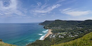
Gerringong is a town located about ten minutes drive south of Kiama, and about twenty minutes north of Nowra in the Illawarra region of New South Wales, Australia in the Municipality of Kiama. At the 2016 census, Gerringong had a population of 3,966. One theory says that the name derives from an Aboriginal word meaning "fearful place".

Huskisson is a village in New South Wales, Australia in the City of Shoalhaven, on the shores of Jervis Bay. It is 24 km south-east of Nowra.
The Gamilaroi, also known as Gomeroi, Kamilaroi, Kamillaroi and other variations, are an Aboriginal Australian people whose lands extend from New South Wales to southern Queensland. They form one of the four largest Indigenous nations in Australia.

Vincentia is a town in New South Wales, Australia in the City of Shoalhaven, on the shores of Jervis Bay. It is roughly 25 kilometres (16 mi) southeast of Nowra, and approximately 200 kilometres (120 mi) south of Sydney. At the 2016 census, the population of Vincentia was 3,290. It is also a tourist spot with a beach area featuring white sand and a number of motels.

Hyams Beach is a seaside village in the City of Shoalhaven, New South Wales, Australia, on the shores of Jervis Bay. At the 2016 census, it had a population of 112. The village, 180 km south of Sydney, is bordered by two beaches, Chinaman's Beach to the north and Seaman's Beach to the south, with Hyams Beach being in the centre. A seaside resort, its beach is known for having turquoise/aqua-coloured waters and fine, squeaky, brilliantly white sand composed of pure quartz.

The Illawarra escarpment, or officially the Illawarra Range, is the fold-created cliffs and plateau-eroded outcrop mountain range west of the Illawarra coastal plain south of Sydney, in the state of New South Wales, Australia. The range encloses the Illawarra region which stretches from Stanwell Park in the north to Kiama, Gerringong and the Shoalhaven River in the south.

Coalcliff is a town on the coast of New South Wales, Australia, between Sydney and Wollongong.

The Dharawal people, also spelt Tharawal and other variants, are an Aboriginal Australian people, identified by the Dharawal language. Traditionally, they lived as hunter–fisher–gatherers in family groups or clans with ties of kinship, scattered along the coastal area of what is now the Sydney basin in New South Wales.
Stanwell Tops is an exurban locality between the cities of Sydney and Wollongong on the New South Wales, Australia coastline. It lies northwest of Stanwell Park and southwest of Otford.
The Walbunja, also spelt Walbanga and Walbunga, are an Aboriginal Australian people of New South Wales, part of the Yuin nation.
The Barranbinya, also written Baranbinja and other variants, are an Aboriginal Australian people of New South Wales.
The Ankamuti, also spelt Ankamuthi, are an Aboriginal Australian people of the Cape York Peninsula of Queensland.
The Kula, also known as the Kurnu, were an indigenous Australian people of the state of New South Wales.
The Weraerai (Wirraayaraay) were an indigenous Australian people of the state of New South Wales. They are to be distinguished from the Ualarai.

The Illawarra Escarpment State Conservation Area is a protected area located west of Wollongong in eastern Australia. The conservation area is a popular location for recreation, including bush walking, scenic viewing, picnicking, camping, bird watching, rock climbing and horse riding. The park comprises six separate sections extending over 40 kilometres, from Stanwell Park in the north to Horsely in the south.