
The Special Region of Yogyakarta is a province-level special region of Indonesia in southern Java. It is a semi-enclave that is surrounded by on the landward side by Central Java Province to the west, north, and east, but has a long coastline on the Indian Ocean to the south.
Wates is the capital of Kulon Progo Regency, in Yogyakarta Special Region on Java, Indonesia. It is located about 25 km to the west of Yogyakarta.
Demak is a town in Central Java, Indonesia. It is the capital of Demak Regency and the location of the former Sultanate of Demak, briefly the strongest power on the island of Java. The town covers an area of 61.13 km2, and had a population of 110,165 at the 2020 Census.
Klaten Regency is a regency in Central Java province in Indonesia. It covers an area of 701.52 km2 and had a population of 1,130,047 at the 2010 Census and 1,260,506 at the 2020 Census; the official estimate as at mid 2023 was 1,284,386. Its administrative centre is in the town of the same name; the town extends over 35.85 km2 to encompass three of the regency's districts, with a combined total of 135,681 inhabitants in mid 2023; a fourth district (Kalikotes) is part of its urban area.

Bantul is a town and district, and the capital of Bantul Regency, Special Region of Yogyakarta, Indonesia. The district (kapanewon) covers an area of 21.95 km2 (8.47 sq mi) and had a population of 64,360 at the 2020 Census. It is a bustling town about 10 km (6.2 mi) to the south of Yogyakarta, easily reached by regular minibuses from the main Yogyakarta bus station. Bantul has numerous firms and agencies which supply services to the surrounding area. A main road runs down from Yogyakarta through Bantul to the busy beach area of Parangtritis visited by many tourists from Yogyakarta each weekend.
Sleman is a kapanewon and the seat capital of Sleman Regency, Special Region of Yogyakarta, Indonesia. It is on the road between Yogyakarta and Magelang. Sleman consists of five villages, namely Caturharjo, Pandowoharjo, Tridadi, Triharjo, and Trimulyo.

Gunungkidul is a regency area located in the Special Province of the Daerah Istimewa Yogyakarta, Indonesia. The administrative centre is the town of Wonosari. The name "Gunungkidul" comes from the Javanese language mountains in the south of Java Land, whose area is located in the Thousand Mountains range of the province.
Sukoharjo Regency is a regency in the Central Java province in Indonesia. It covers an area of 493.23 km2 and had a population of 824,238 at the 2010 Census and 907,587 at the 2020 Census; the official estimate as of mid-2023 was 932,680. Its administrative centre is in the town of Sukoharjo, about 10 km south of Surakarta. This regency is bordered by the city of Surakarta in the north, Karanganyar Regency in the east, Wonogiri Regency and Yogyakarta in the south as well as Klaten Regency in the west. The regency is part of the metropolitan zone of Surakarta, which is known as Subosukawonosraten.
Sragen Regency is a regency in the eastern part of Central Java province in Indonesia. It covers an area of 994.57 km2 and had a population of 858,266 at the 2010 Census and 976,951 at the 2020 Census; the official estimate as at mid 2023 was 997,485. Its capital is the town of Sragen, located about 30 km to the northeast of Surakarta. Sragen is bordered by East Java Province to the east.
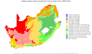
The climate of South Africa is determined by South Africa's situation between 22°S and 35°S, in the Southern Hemisphere's subtropical zone, and its location between two oceans, Atlantic and the Indian.
Sekolah Menegah Atas 1 Wonosari is the oldest high school in Wonosari, Gunungkidul Regency. It was established in 1962.

Opak River is a river in central south area of Java island, Indonesia.
Ungaran is a town in Central Java, Indonesia and the administrative centre of the Semarang Regency in the province of Central Java. Ungaran is located at -7° 8' 17", 110° 24' 18" at an elevation of 319 metres. It encompasses two districts (kecamatan) within the Regency - Ungaran Barat and Ungaran Timur.
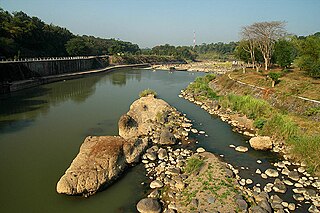
The Progo River is a river in southern central Java, Indonesia. The river passes through two provinces; Central Java and Yogyakarta Special Region. The source of the river is on the slopes of Mount Sindoro, Central Java.
The Oyo River is a river in southern Central Java and Yogyakarta, in the central south area of Java island, Indonesia. It is a tributary of the Opak River.
Paguyaman River is a river in Gorontalo (province), Sulawesi island, Indonesia, about 1900 km northeast of capital Jakarta.

Timang beach is a beach attraction at the boundary between the sea and the land that is located in Gunungkidul, Yogyakarta, Indonesia. Timang beach lies between Siung and Sundak beach in Gunungkidul. The uniqueness of this beach is that there is an island called Panjang Island which is lobster habitat across coastal marine.
Tepus is a regency district (kapanewon) of Gunung Kidul Regency, Yogyakarta Special Region, Indonesia. The boundaries of Tepus District are with Girisubo District on the east side, Semanu District on the north side, Tanjungsari on the west side and the Indian Ocean on the South side.
Pedukuhan Ngande - Ande is located in Kelurahan Purwodadi, Kecamatan Tepus, Gunungkidul, Yogyakarta Special Region, Indonesia. The name of Ngande - Ande comes from the tree, called Ande-ande Tree.
Persatuan Sepakbola Indonesia Gunung Kidul is an Indonesian football club from Gunung Kidul Regency, Special Region of Yogyakarta. Currently Persig Gunungkidul competes in the Indonesian League Third Division DIY zone, Liga 3.

