
The Baumgardener's Covered Bridge is a covered bridge that spans Pequea Creek in Lancaster County, Pennsylvania, United States. A county-owned and maintained bridge, its official designation is the Pequea #10 Bridge. Note: The mill was constructed in 1800.

The Bucher's Mill Covered Bridge or Butcher's Mill Covered Bridge is a covered bridge that spans Cocalico Creek in Lancaster County, Pennsylvania, United States. After the Landis Mill Covered Bridge, it is the second shortest covered bridge in the county. A county-owned and maintained bridge, its official designation is the Cocalico #2 Bridge.

The Colemanville Covered Bridge is a covered bridge that spans Pequea Creek in Lancaster County, Pennsylvania, United States. After Hunsecker's Mill Covered Bridge, it is Lancaster County's second-longest single-span covered bridge still being used. It is also referred to as the Martic Forge Covered Bridge and Pequea #12 Bridge.

The Kauffman's Distillery Covered Bridge or Sporting Hill Bridge is a covered bridge that spans Chiques Creek in Lancaster County, Pennsylvania, United States. A county-owned and maintained bridge, its official designation is the Big Chiques #1 Bridge.

The Shearer's Covered Bridge is a covered bridge that spans the Big Chiques Creek in Lancaster County, Pennsylvania, United States..
Red Clay Creek is a 12.7-mile-long (20.4 km) tributary of White Clay Creek, running through southeastern Pennsylvania and northern Delaware in the United States. As of 2000, portions of the creek are under wildlife habitat protection.

The Uhlerstown–Frenchtown Bridge is a free bridge over the Delaware River, owned and operated by the Delaware River Joint Toll Bridge Commission. The bridge connects New Jersey Route 12 in Frenchtown of Hunterdon County, New Jersey with Pennsylvania Route 32 in Uhlerstown of Bucks County, Pennsylvania.
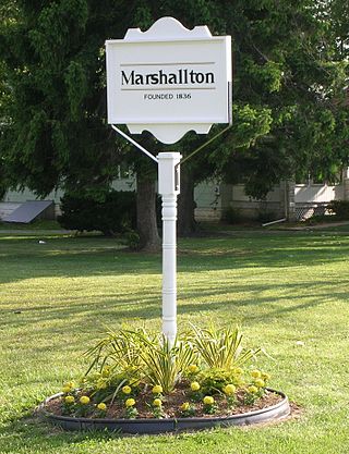
Marshallton is an unincorporated community in Mill Creek Hundred, New Castle County, Delaware, United States. The community was founded in 1836 and is named for John Marshall, mill owner.

The Erb's Covered Bridge is a covered bridge that spans Hammer Creek in Lancaster County, Pennsylvania, United States. A county-owned and maintained bridge, its official designation is the Hammer Creek #1 Bridge.
The Sonestown Covered Bridge is a covered bridge over Muncy Creek in Davidson Township, Sullivan County, Pennsylvania built around 1850. It is 110 ft (34 m) long and was placed on the National Register of Historic Places (NRHP) in 1980. It is named for the nearby unincorporated village of Sonestown in Davidson Township, and is also known as the Davidson Covered Bridge. It was built to provide access to a grist mill which operated until the early 20th century.

The Forksville Covered Bridge is a Burr arch truss covered bridge over Loyalsock Creek in the borough of Forksville, Sullivan County, in the U.S. state of Pennsylvania. It was built in 1850 and is 152 feet 11 inches (46.61 m) in length. The bridge was placed on the National Register of Historic Places in 1980. The Forksville bridge is named for the borough it is in, which in turn is named for its location at the confluence or "forks" of the Little Loyalsock and Loyalsock Creeks.

The Union Covered Bridge State Historic Site is a Missouri State Historic Site in Monroe County, Missouri. The covered bridge is a Burr-arch truss structure built in 1871 over the Elk Fork of the Salt River. It was almost lost to neglect in the 1960s, but was added to the state park system in 1967, the same year it was damaged by a flood. Repairs were made the next year, using timbers salvaged from another covered bridge that had been destroyed by the same flood. In 1970, it was closed to vehicular traffic and was added to the National Register of Historic Places. Further repairs were made in 1988, and it survived the Great Flood of 1993, only to be damaged by another flood in 2008 and later re-repaired. It is about 120 feet (37 m) or 125 feet (38 m) long, 12 feet (3.7 m) high, and 17.5 feet (5.3 m) wide.
Ashland is an unincorporated community in New Castle County, Delaware, United States. Ashland is located at the intersection of Delaware Route 82 and Barley Mill Road along the Red Clay Creek.
Wooddale is an unincorporated community in New Castle County, Delaware, United States. Wooddale is located along the Red Clay Creek and Rolling Mill Road, west of Wilmington.
The Ashland Mill Bridge was a lenticular pony truss bridge over the Pachaug River in Griswold, Connecticut that was built in 1886 by the Berlin Iron Bridge Company. It was built following the Ashland dam break of February 1886 which washed away the previous bridges. The bridge served the millyard of the Ashland Cotton Company, in the Jewett City section of Griswold. The bridge was 65 feet (20 m) long and crossed a millrace on a skew angle. The Ashland Mill was damaged by arson in March 1995 and subsequently torn down, but the bridge itself remained. By 1999, the town deemed the bridge unsafe and closed it, and by February 1999, the bridge was moved to a vacant parking lot and was replaced with a new bridge. The bridge was added to the state of Connecticut historic register and it was later added to the National Register of Historic Places in April 1999. It was removed from the National Register in February 2016.

Ashland Covered Bridge, also known as Ashland Bridge or Barley Mill Road Covered Bridge, is a covered bridge over Red Clay Creek on Barley Mill Road in Ashland in New Castle County, Delaware. It was added to the National Register of Historic Places in 1973.

The Upper Cox Brook Covered Bridge is a wooden covered bridge that crosses Cox Brook on Cox Brook Road in Northfield, Vermont. It is one of five surviving 19th-century covered bridges in the town, and one of three on the same road. It was listed on the National Register of Historic Places in 1974.

The Hammond Covered Bridge is a Town lattice covered bridge spanning Otter Creek in Pittsford, Vermont. The bridge was built in 1842 by Asa Norse, and originally carried Kendall Hill Road, which now passes just to its south. The bridge was added to the National Register of Historic Places on January 21, 1974.
Thomas Creek is a stream, about 35 miles (56 km) long, in Linn County in the U.S. state of Oregon. Beginning in Willamette National Forest on the western slopes of the Cascade Range, the creek flows generally west through Santiam State Forest and farmland to meet the South Santiam River west of Scio.

The Winooski Street Bridge is a historic bridge carrying Winooski Street across the Winooski River between Duxbury and Waterbury, Vermont. Built in 1928, it is a Parker through truss, one of only two of this type on the Winooski River and an increasingly rare bridge type in the state. It was listed on the National Register of Historic Places in 2006 as Bridge 31.


