The Center for Brooklyn History is a museum, library, and educational center founded in 1863 that preserves and encourages the study of Brooklyn's 400-year history. The center's Romanesque Revival building, located at Pierrepont and Clinton Streets in Brooklyn Heights, was designed by George B. Post and built in 1878–1881 by David H. King Jr., is a National Historic Landmark and part of New York City's Brooklyn Heights Historic District. The CBH houses materials relating to the history of Brooklyn and its people, and hosts exhibitions which draw over 9,000 members a year. In addition to general programming, the CBH serves over 70,000 public school students and teachers annually by providing exhibit tours, educational programs and curricula, and making its professional staff available for instruction and consultation.

The West Cornwall Covered Bridge is a wooden covered lattice truss bridge carrying the Sharon-Goshen Turnpike over the Housatonic River in the town of Cornwall, Connecticut. Records indicate that a bridge may have been in place in this location as early as 1762. A previous bridge was destroyed in the flood of 1837 and a new bridge was constructed in 1841. This bridge would also be destroyed and the current bridge would be completed circa 1864. Utilizing the central pier from the previous incarnation, despite the Town lattice being able to withstand the weight and single span, the bridge has two spans. The later addition of queen trusses and supports gives the bridge an unusual appearance. Modernization of the bridge in 1968 and 1973 has continued to let the bridge handle traffic. It was added to the National Register of Historic Places in 1975.

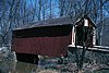
The Covered Bridge in Cedarburg, Ozaukee County, Wisconsin, United States, is one of the last remaining covered bridges in that state, which once had about 40 covered bridges. Built in 1876 to cross Cedar Creek, the bridge is 120 feet (37 m) long and is made of pine with oak lattices. It was listed on the National Register of Historic Places in 1973 and is now used only for pedestrian traffic.
This is a timeline and chronology of the history of Brooklyn, New York. Brooklyn is the most populous of New York City's boroughs, and was settled in 1646.

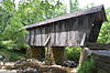
The Cataract Falls Covered Bridge is a covered bridge that spans Mill Creek in Lieber State Recreation Area, Owen County, Indiana. Built in 1876 by the Smith Bridge company of Toledo, Ohio, it was at one time one of the most famous and photographed covered bridges in the United States. It is the only remaining one in Owen County.