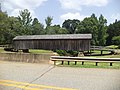
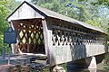
Name Image Location [A] Year built Length Crosses Design Historical Notes Auchumpkee Creek Covered Bridge [ 1] Thomaston , Upson County 32°45′20″N 84°13′49″W / 32.7556°N 84.2302°W / 32.7556; -84.2302 Geographic data related to Auchumpkee Creek Covered Bridge at OpenStreetMap
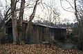
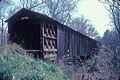
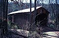
1892, rebuilt 1997 96 feet (29 m) Auchumpkee Creek Town lattice Listed on the National Register of Historic Places [ 2] Big Red Oak Creek Covered Bridge [ 1] Woodbury , Meriwether County c. 1840s 252.5 feet (77.0 m) Red Oak Creek Town lattice Listed on the National Register of Historic Places [ 2] Wehadkee Creek Bridge-formerly Callaway Gardens Covered Bridge [ 1] LaGrange, Troup County 1873; rebuilt in 1890 60 feet (18 m) Cary Branch Town lattice Coheelee Creek Covered Bridge [ 1] Blakely , Early County 31°18′23″N 85°04′43″W / 31.30639°N 85.07861°W / 31.30639; -85.07861 1891 96 feet (29 m) Coheelee Creek Modified Queen Post Listed on the National Register of Historic Places [ 2] Concord Covered Bridge [ 3] Smyrna , Cobb County 1872 131.7 feet (40.1 m) Nickajack Creek Queen-rod Listed on the National Register of Historic Places [ 2] Cromer's Mill Covered Bridge [ 3] Carnesville , Franklin County 1906 132 feet (40 m) Nails Creek Town lattice Listed on the National Register of Historic Places [ 2] Elder's Mill Covered Bridge [ 3] Watkinsville , Oconee County 1897 100 feet (30 m) Rose Creek Town lattice Listed on the National Register of Historic Places [ 2] Euharlee Covered Bridge [ 3] Euharlee , Bartow County 1886 137.6 feet (41.9 m) Euharlee Creek Town lattice Howard's Covered Bridge [ 3] Oglethorpe County 1905 168 feet (51 m) Big Clouds Creek Town lattice Listed on the National Register of Historic Places [ 2] Hurricane Shoals Covered Bridge [ 4] Maysville , Jackson County 1884, burned in 1972, rebuilt 2002 127 feet (39 m) North Oconee River Town lattice Kesler Covered Bridge [ 5] Homer , Banks County 1925 69 feet (21 m) Broad River King post to one side, Queen post to the other Listed on the National Register of Historic Places [ 2] Kilgore Mill Covered Bridge [ 1] Barrow County and Walton County 1894 117 feet (36 m) Apalachee River Town lattice Listed on the National Register of Historic Places [ 2] Lula Covered Bridge [ 3] Gainesville , Hall County 1915 34 feet (10 m) Grove Creek King post Also known as Blind Susie Covered Bridge, locally. [ 6] New Salem Covered Bridge [ 7] Commerce , Jackson County 1915 47 feet (14 m) Grove Creek King post Listed on the National Register of Historic Places [ 2] Poole's Mill Covered Bridge [ 3] Cumming , Forsyth County 1901 94.6 feet (28.8 m) Settendown Creek Town lattice Listed on the National Register of Historic Places [ 2] Rockdale County Covered Bridge [ 3] Conyers , Rockdale County 1997 150 feet (46 m) Mill Rock Creek Decorative lattice Stone Mountain Covered Bridge [ 3] Stone Mountain Park , DeKalb County 1891 151 feet (46 m) Stone Mountain Park Lake Town lattice Stovall Mill Covered Bridge [ 3] Helen , White County 1895 36.8 feet (11.2 m) Chickamauga Creek Queen post Watson Mill Bridge State Park [ 3] Comer , Madison County 1885 228.6 feet (69.7 m) South fork of the Broad River Town lattice Listed on the National Register of Historic Places [ 2] White Oak Creek Covered Bridge [ 1] Alvaton , Meriwether County 1880, burned in 1985 N/A N/A Town lattice Listed on the National Register of Historic Places [ 2]