
Natural Bridge is a geological formation in Rockbridge County, Virginia, United States, comprising a 215-foot-high (66 m) natural arch with a span of 90 feet (27 m). It is situated within a gorge carved from the surrounding mountainous limestone terrain by Cedar Creek, a small tributary of the James River. Consisting of horizontal limestone strata, Natural Bridge is the remains of the roof of a cave or tunnel through which the Cedar Creek once flowed.
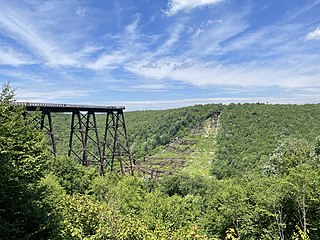
Kinzua Bridge State Park is a 339-acre (137 ha) Pennsylvania state park near Mount Jewett, in Hamlin and Keating Townships, McKean County, Pennsylvania in the United States. The park lies between U.S. Route 6 and Pennsylvania Route 59, along State Route 3011 just east of the Allegheny National Forest.

Arrow Rock State Historic Site is an open-air museum encompassing bluffs along the Missouri River and a portion of the village of Arrow Rock, Missouri. The park is part of the Arrow Rock Historic District, a National Historic Landmark, and commemorates the history of the area as a key stop on the Santa Fe Trail.

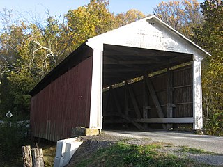
The Bollinger Mill State Historic Site is a state-owned property preserving a mill and covered bridge that pre-date the American Civil War in Burfordville, Cape Girardeau County, Missouri. The park was established in 1967 and offers mill tours and picnicking. It is managed by the Missouri Department of Natural Resources. It includes the Burfordville Covered Bridge, which is listed on the National Register of Historic Places.
Hillman State Park is a 3,654-acre (1,479 ha) Pennsylvania state park in Hanover Township, Washington County in the United States. It is about 25 miles (40 km) west of Pittsburgh. The park opened in the late 1960s and has been managed for hunting by the Pennsylvania Game Commission since the early 1980s. The park also has hiking, cross-country skiing, horseback riding, a radio-controlled aircraft field, and mountain bike trails that are open to the public. The largely undeveloped park is north of U.S. Route 22 and east of Pennsylvania Route 18 in northern Washington County near the village of Bavington and the borough of Burgettstown. Part of the park has been designated as Pennsylvania State Game Lands 117.

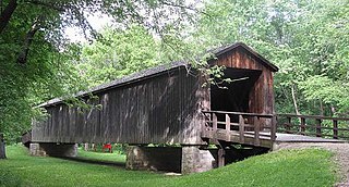
The Big Rocky Fork Covered Bridge is located 1 mile (1.6 km) southeast of Mansfield, Indiana, on County Road 720 and about 2 miles (3.2 km) east of State Road 59, in Parke County.

The Crooks Covered Bridge is a single span Burr Arch Truss structure that crosses Little Raccoon Creek built in 1855-1856 by Henry Wolf just southeast of Rockville, Indiana.
The Billie Creek Covered Bridge is a Burr Arch structure that was built by Joseph J. Daniels in 1895. J.L. Van Fossen supplied the sandstone that makes up the abutments cut from A.E. Fuel's nearby quarry.

The Catlin Covered Bridge is a single span Burr Arch truss covered bridge structure that was built by Clark McDaniel in 1907.

The Rush Creek Covered Bridge is south of Tangier, Indiana. The single span Burr Arch covered bridge structure was built by William Hendricks in 1904.

The Wilkins Mill Covered Bridge is north of Rockville, Indiana, United States. The single span Burr Arch Truss covered bridge structure was built by William Hendricks in 1906. The bridge is 120 feet (37 m) long, 16 feet (4.9 m) wide, and 13 feet (4.0 m) high.
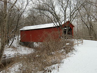
Sandy Creek Covered Bridge State Historic Site is a publicly owned property in Jefferson County, Missouri, administered by the Missouri Department of Natural Resources, preserving the Sandy Creek Covered Bridge. The bridge is one of four remaining covered bridges in Missouri, which once numbered about 30. It is a relatively rare example of a Howe truss bridge, one of three in Missouri. The covered bridge is named for Sandy Creek, which it crosses, and was added to the National Register of Historic Places in 1970.

The Dillard Mill State Historic Site is a privately owned, state-administered property on Huzzah Creek in Crawford County, Missouri, that preserves a water-powered gristmill. The 132-acre (53 ha) site has been operated as a state historic site by the Missouri Department of Natural Resources under a lease agreement with the L-A-D Foundation since 1975. The site was listed on the National Register of Historic Places in 2015.

Gen. John J. Pershing Boyhood Home State Historic Site in Laclede, Missouri, is maintained by the Missouri Department of Natural Resources as a state historic site. General John Joseph "Jack" Pershing led the American Expeditionary Forces in World War I and attained the rank of General of the Armies. Pershing was born on a farm outside Laclede, but lived in the home from age six to adulthood. The historic site preserves and interprets the boyhood home and the one-room Prairie Mound School at which he taught for a year before attending West Point Military Academy. The home has been listed on the National Register of Historic Places since 1969, and was designated a National Historic Landmark in 1976.

Knob Noster State Park is a public recreation area covering 3,934 acres (1,592 ha) in Johnson County, Missouri, in the United States. The state park bears the name of the nearby town of Knob Noster, which itself is named for one of two small hills or "knobs" that rise up in an otherwise flat section of Missouri. Noster is a Latin adjective meaning "our"—therefore, Knob Noster translates as "our hill." A local Indian belief stated that the hills were "raised up as monuments to slain warriors." The park offers year-round camping, hiking, and fishing and is managed by the Missouri Department of Natural Resources.
Locust Creek Covered Bridge State Historic Site is a publicly owned property in Linn County, Missouri, maintained as a state historic site by the Missouri Department of Natural Resources. Also called the Linn County Bridge, the covered bridge is located about 3 miles (4.8 km) east of Meadville, Missouri. At a length of 151 feet (46 m) with a width of 16 ft 8 in (5.08 m) it is the longest of the four remaining covered bridges in the state of Missouri. It was listed on the National Register of Historic Places in 1970.

Pershing State Park is a public recreation area covering more than 5,000 acres (2,000 ha) off U.S. Route 36, three miles west of Laclede in Linn County, Missouri. The state park was named in honor of General of the Armies John J. Pershing, who led the United States forces in Europe in World War I and who grew up in Laclede.

Rock Bridge Memorial State Park is a geological preserve and public recreation area encompassing 2,273 acres (920 ha), five miles (8.0 km) south of Columbia in Boone County, Missouri off of Missouri Route 163. The state park is home to 12 caves and is noted for its excellent examples of karst landforms including the rock bridge, sinkholes, and an underground stream at the cave known as Devil's Icebox. The rock bridge was created by the collapse of a section of a cave which resulted in a small arch of rock being left to form a natural bridge over the creek. The park is the only known home of Kenkia glandulosa, a flatworm commonly known as the pink planarian.

The Union Covered Bridge State Historic Site is a Missouri State Historic Site in Monroe County, Missouri. The covered bridge is a Burr-arch truss structure built in 1871 over the Elk Fork of the Salt River. It was almost lost to neglect in the 1960s, but was added to the state park system in 1967, the same year it was damaged by a flood. Repairs were made the next year, using timbers salvaged from another covered bridge that had been destroyed by the same flood. In 1970, it was closed to vehicular traffic and was added to the National Register of Historic Places. Further repairs were made in 1988, and it survived the Great Flood of 1993, only to be damaged by another flood in 2008 and later re-repaired. It is about 120 feet (37 m) or 125 feet (38 m) long, 12 feet (3.7 m) high, and 17.5 feet (5.3 m) wide.


