List of covered bridges in Illinois

Last updated

List of covered bridges in Illinois

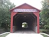
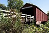
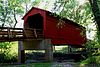
Below is a list of covered bridges in Illinois. There are nine authentic covered bridges in the U.S. state of Illinois. Five of them are historic. [1] A covered bridge is considered authentic not due to its age, but by its construction. An authentic bridge is constructed using trusses rather than other methods such as stringers, a popular choice for non-authentic covered bridges.

Contents

Bridges

NameImageCountyLocationBuiltLengthCrossesOwnershipTrussNotes
Captain Swift Covered Bridge [2] CAPTAIN SWIFT COVERED BRIDGE, BUREAU COUNTY, ILLINOIS.JPG Bureau Princeton
41°22′44″N89°29′52″W / 41.37889°N 89.49778°W / 41.37889; -89.49778 (Captain Swift Covered Bridge)
2007128 feet (39 m) Bureau Creek Pratt variant and arches
Jackson Covered Bridge [2] Cumberland Greenup
39°14′20″N88°11′14″W / 39.23889°N 88.18722°W / 39.23889; -88.18722 (Jackson Covered Bridge)
2000192 feet (59 m) Embarras River Multiple king and arch
Mary's River Covered Bridge [1] [3] Mary's River Covered Bridge.jpg Randolph Chester
37°56′55″N89°45′57″W / 37.94861°N 89.76583°W / 37.94861; -89.76583 (Mary's River Covered Bridge)
1854, restored 1954 and 200598 feet (30 m) Little Marys River Illinois DOT Burr
Oquawka Wagon Bridge [1] [3] Oquawka Wagon Bridge.jpg Henderson Oquawka
40°53′39″N90°56′57″W / 40.89417°N 90.94917°W / 40.89417; -90.94917 (Oquawka Wagon Bridge)
1866, restored 1982106 feet (32 m) Henderson Creek State of Illinois Burr Also called Allaman or Eames Bridge
Red Covered Bridge [1] [3] Red Covered Bridge, Princeton, Illinois (7881773738).jpg Bureau Princeton
41°24′59″N89°28′43″W / 41.41639°N 89.47861°W / 41.41639; -89.47861 (Red Covered Bridge)
186393 feet (28 m) Big Bureau Creek Illinois DOT Howe
Rockford Bolt Co. [2] Boone North Caledonia
42°24′41″N88°56′22″W / 42.41139°N 88.93944°W / 42.41139; -88.93944 (Rockford Bolt Co. Covered Bridge)
189075 feet (23 m)Kinnikinnick CreekPrivate Howe Also called Young Covered Bridge
Stickelback Covered Bridge [2] Kendall Newark
41°35′9″N88°35′20″W / 41.58583°N 88.58889°W / 41.58583; -88.58889 (Stickelback Covered Bridge)
202045 feet (14 m) Stream Town
Sugar Creek Covered Bridge [1] [3] Sugar Creek Covered Bridge.JPG Sangamon Chatham
39°38′25″N89°39′43″W / 39.64028°N 89.66194°W / 39.64028; -89.66194 (Sugar Creek Covered Bridge)
1827 or 1880, restored 196558 feet (18 m) Sugar Creek Illinois DOT Multiple king with arch Also called Glenarm or Hedley Bridge
Thompson Mill Covered Bridge [1] [3] Thompson Mill Covered Bridge from southwest.jpg Shelby Cowden
39°15′30″N88°49′5″W / 39.25833°N 88.81806°W / 39.25833; -88.81806 (Thompson Mill Covered Bridge)
1868105 feet (32 m) Kaskaskia River Illinois DOT Howe Also called Dry Point Bridge
Wolf Covered Bridge [2] Knox Haw Creek
40°51′24″N90°6′36″W / 40.85667°N 90.11000°W / 40.85667; -90.11000 (Wolf Covered Bridge)
1999102 feet (31 m) Spoon River Howe Replaced a covered bridge built in 1865

See also

Related Research Articles

<span class="mw-page-title-main">National Register of Historic Places listings in Colorado</span> List of National Register of Historic Places in the U.S. State of Colorado

There are more than 1,500 properties and historic districts in the U.S. State of Colorado listed on the National Register of Historic Places. They are distributed over 63 of Colorado's 64 counties; only the City and County of Broomfield currently has none.

<span class="mw-page-title-main">National Register of Historic Places listings in El Paso County, Colorado</span> List of National Register of Historic Places in El Paso County, Colorado, United States

This is a list of the National Register of Historic Places listings in El Paso County, Colorado.

References

  1. 1 2 3 4 5 6 Blanchette, David (July 1995). "The Bridges of Sangamon County". Illinois Municipal Review: 11–12. Retrieved 10 May 2020.
  2. 1 2 3 4 5 Caswell, William S. World Guide to Covered Bridges (2021 ed.). Concord, New Hampshire: National Society for the Preservation of Covered Bridges. pp. 11–13. ISBN   978-0-578-30263-8.
  3. 1 2 3 4 5 "National Register Information System". National Register of Historic Places . National Park Service. July 9, 2010.