| Name [1] | Image | Location
[1] [A] | Year built [1] | Length | Crosses | Design | Historical Notes |
|---|
| Barrackville Covered Bridge |  | Barrackville, Marion County | 1853 | 146 feet (45 m) | Buffalo Creek | Multiple king post, Burr arch | Built by Lemuel Chenoweth |
| Carrollton Covered Bridge [2] | 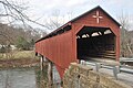 | Carrollton, Barbour County | 1856 | 141 feet (43 m) | Buckhannon River | Multiple king post, Burr arch | Reconstructed 2022 after arson [3] |
| Center Point Covered Bridge |  | Center Point, Doddridge County | 1888 | 42 feet (13 m) | Pike Fork of McElroy Creek | Long truss | |
| Dents Run Covered Bridge |  | Laurel Point, Monongalia County | 1889 | 40 feet (12 m) | Dents Run | King post | |
| Fish Creek Covered Bridge aka "Hundred Covered Bridge" |  | Hundred, Wetzel County | 1881, 2001 [4] | 30 feet (9.1 m) | Fish Creek | King post | |
| Fletcher Covered Bridge aka "Ten Mile Creek Covered Bridge" | | Cutler, Harrison County | 1891 | 58 feet (18 m) | Tenmile Creek | Multiple king post | |
| Herns Mill Covered Bridge aka "Milligan Creek Covered Bridge" | 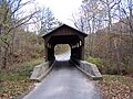 | Asbury, Greenbrier County | 1884 | 54 feet (16 m) | Milligans Creek | Queen post | |
| Hokes Mill Covered Bridge aka "Second Creek Covered Bridge" | 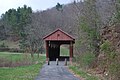 | Hokes Mill, Greenbrier County | 1899 | 82 feet (25 m) | Second Creek | Long truss | |
| Indian Creek Covered Bridge | 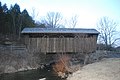 | Union, Monroe County | 1903 | 48 feet (15 m) | Indian Creek | Long truss | |
| Laurel Creek Covered Bridge aka "Lily Dale Covered Bridge" |  | Lillydale, Monroe County | 1911 | 22 feet (6.7 m) | Laurel Creek | Howe truss | |
| Locust Creek Covered Bridge |  | Hillsboro, Pocahontas County | 1870 | 113 feet (34 m) | Monroe Creek | Warren truss | |
| Mud River Covered Bridge |  | Milton, Cabell County | 1875 | 108 feet (33 m) | Mud River | Howe truss | |
| Philippi Covered Bridge |  | Philippi, Barbour County | 1852 | 285 feet (87 m) | Tygart Valley River | Long truss with Burr arch | Built by Chenoweth |
| Sarvis Fork Covered Bridge aka "Sandy Creek Covered Bridge" and "New Era Covered Bridge" |  | Sandyville, Jackson County | 1889, 2000 [4] | 101 feet (31 m) | Left Fork Sandy Creek | Long truss | |
| Simpson Creek Covered Bridge aka "Hollens Mill Covered Bridge" | | Bridgeport, Harrison County | 1881 | 74 feet (23 m) | Simpson Creek | Multiple king post | |
| Staats Mill Covered Bridge |  | Ripley, Jackson County | 1887 | 97 feet (30 m) | Pond [4] | Long truss | Originally over Tug Fork, Big Mill Creek |
| Walkersville Covered Bridge | 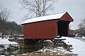 | Walkersville, Lewis County | 1903 | 54 feet (16 m) | Right Fork of West Fork River | Queen post | |


