List of covered bridges in Kentucky

Last updated

List of covered bridges in Kentucky

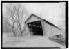
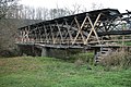
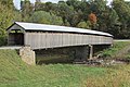
Below is a list of covered bridges in Kentucky. There are eleven surviving authentic covered bridges in the U.S. state of Kentucky, and they are all historic. [1] A covered bridge is considered authentic not due to its age, but by its construction. An authentic bridge is constructed using trusses rather than other methods such as stringers, a popular choice for non-authentic covered bridges. There once were hundreds of these in Kentucky.

Contents

Bridges

Extant

NameImageCountyLocationBuiltLengthCrossesOwnershipTrussNotes
Bennett's Mill Covered Bridge [2] Perspective, due north. - Bennett's Mill Bridge, Spanning Tygart's Creek, East Tygart's Creek Road (CR 1215), Lynn, Greenup County, KY HAER KY-49-1.tif Greenup Greenup
38°37′50″N82°55′37″W / 38.63056°N 82.92694°W / 38.63056; -82.92694 (Bennett's Mill Covered Bridge)
ca. 1855, 2004145 feet (44 m) Tygarts Creek County of Greenup Modified Wheeler or Warren
Cabin Creek Covered Bridge [2] CabinCreekCoveredBridge.jpg Lewis Tollesboro
38°37′13″N83°37′16″W / 38.62028°N 83.62111°W / 38.62028; -83.62111 (Cabin Creek Covered Bridge)
ca. 1867114 feet (35 m)Cabin Creek State of Kentucky Multiple king Also called C.F. Ferguson Farm, Mackey, or Hughes Farm Covered Bridge [3]
Colville Covered Bridge [2] Colville Bridge02.jpg Bourbon Millersburg
38°19′29″N84°12′12″W / 38.32472°N 84.20333°W / 38.32472; -84.20333 (Colville Covered Bridge)
1877, 2002120 feet (37 m)Hinkston Creek County of Bourbon Multiple king
Goddard Bridge [2] GoddardBridge.jpg Fleming Goddard
38°21′44″N83°36′56″W / 38.36222°N 83.61556°W / 38.36222; -83.61556 (Goddard Bridge)
1864, 193360 feet (18 m)Sand Lick Creek County of Fleming Town Also called White Bridge [3]
Hillsboro Covered Bridge [2] HillsboroCoveredBridge.jpg Fleming Hillsboro
38°15′17″N83°39′11″W / 38.25472°N 83.65306°W / 38.25472; -83.65306 (Hillsboro Covered Bridge)
ca. 186580 feet (24 m)Fox Creek County of Fleming Multiple king Also called Grange City Covered Bridge [3]
Johnson Creek Covered Bridge [2] JohnsonCreekCoveredBridge.jpg Robertson Mount Olivet
38°28′52″N83°58′37″W / 38.48111°N 83.97694°W / 38.48111; -83.97694 (Johnson Creek Covered Bridge)
1874110 feet (34 m)Blue Lick Springs County of Robertson Smith
Lee's Creek Covered Bridge [2] DoverBridge.JPG Mason Dover
38°44′59″N83°52′44″W / 38.74972°N 83.87889°W / 38.74972; -83.87889 (Lee's Creek Covered Bridge)
183560 feet (18 m)Lee's Creek County of Mason Queen Also called Dover Covered Bridge [3]
Oldtown Covered Bridge [2] OLDTOWN COVERED BRIDGE.jpg Greenup Oldtown
38°25′53″N82°53′42″W / 38.43139°N 82.89500°W / 38.43139; -82.89500 (Oldtown Covered Bridge)
1850-1874, 1999190 feet (58 m)Frazer Branch, Little Sandy Creek County of Greenup Warren or Multiple king
Ringos Mill Covered Bridge [2] RingosMill.jpg Fleming Flemingsburg
38°16′6″N83°36′38″W / 38.26833°N 83.61056°W / 38.26833; -83.61056 (Ringos Mill Covered Bridge)
186786 feet (26 m)Fox Creek County of Fleming Multiple king
Switzer Covered Bridge [2] Switzer CB P6170422.jpg Franklin Switzer
38°15′14″N84°45′8″W / 38.25389°N 84.75222°W / 38.25389; -84.75222 (Switzer Covered Bridge)
1855, 1998120 feet (37 m)North Fork, Elkhorn Creek County of Franklin Howe
Walcott Covered Bridge [2] WalcottCoveredBridge.jpg Bracken Brooksville
38°44′0″N84°6′2″W / 38.73333°N 84.10056°W / 38.73333; -84.10056 (Walcott Covered Bridge)
ca. 1880, 200176 feet (23 m)Locust CreekPrivate Queen and multiple king

Former

NameImageCountyLocationBuiltLengthCrossesOwnershipTrussNotes
Mount Zion Covered Bridge [2] Mt Zion CB 19-10-19 839.jpg Washington Mooresville
37°49′40″N85°15′23″W / 37.82778°N 85.25639°W / 37.82778; -85.25639 (Mount Zion Covered Bridge)
1871–2021258 feet (79 m) Beech Fork Kentucky Department of Highways Burr Also called Beech Fork Covered Bridge. [3] Lost to arson on March 9, 2021. [4]
Valley Pike Covered Bridge [3] ValleyPikeBridge.jpg Mason Fernleaf
38°40′27″N83°52′20″W / 38.67417°N 83.87222°W / 38.67417; -83.87222 (Valley Pike Covered Bridge)
186435 feet (11 m)Lee's CreekPrivate King Also called Bouldin or Daugherty Covered Bridge. Dismantled on April 27, 2018. [4]

See also

Related Research Articles

<span class="mw-page-title-main">Valley Pike Covered Bridge</span> United States historic place

The Valley Pike Covered Bridge was a historic covered bridge located in Mason County, Kentucky, United States. It crossed the Frasure Branch of Lee Creek. It was added to the National Register of Historic Places in 1976. The bridge was dismantled after flood damage on April 27, 2018.

References

  1. "12 Historic Covered Bridges in Kentucky". Only in Your State. Leaf Group Lifestyle. Retrieved 17 May 2020.
  2. 1 2 3 4 5 6 7 8 9 10 11 12 "National Register Information System". National Register of Historic Places . National Park Service. July 9, 2010.
  3. 1 2 3 4 5 6 Wright, David W. (2009). World Guide to Covered Bridges (2009 ed.). Concord, New Hampshire: National Society for Preservation of Covered Bridges. pp. 33–36. ISBN   978-0-692-00617-7.
  4. 1 2 Caswell, William S. World Guide to Covered Bridges (2021 ed.). Concord, New Hampshire: National Society for the Preservation of Covered Bridges. p. xxxii. ISBN   978-0-578-30263-8.

Further reading

Robert W. M. Laughlin; Melissa C. Jurgensen (2007). Kentucky's Covered Bridges. Charleston, South Carolina: Arcadia Publishing. ISBN   978-0-738-54404-5.